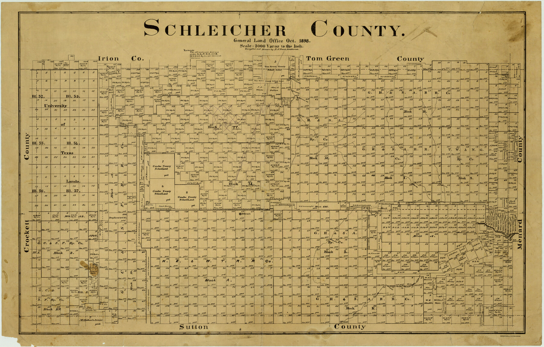
Schleicher County
-
Map/Doc
615
-
Collection
Maddox Collection
-
Object Dates
1898 (Creation Date)
-
People and Organizations
General Land Office (Publisher)
Maverick-Clarke (Printer)
Sid J. Rowe (Draftsman)
Sid J. Rowe (Compiler)
-
Counties
Schleicher
-
Subjects
County
-
Height x Width
23.1 x 36.3 inches
58.7 x 92.2 cm
Part of: Maddox Collection
Survey of a Portion of Lot. No. 1 of Spear League

Print $20.00
- Digital $50.00
Survey of a Portion of Lot. No. 1 of Spear League
1911
Size 12.2 x 24.2 inches
Map/Doc 477
Map of South Brady Ranch, Concho County, Texas

Print $3.00
- Digital $50.00
Map of South Brady Ranch, Concho County, Texas
1880
Size 12.9 x 10.5 inches
Map/Doc 424
[Surveying Sketch of Houston and Texas Central R. R. Co., Gunter & Munson, Houston & Great Northern R. R. Co., International & Great Northern R. R. Company, et al]
![75763, [Surveying Sketch of Houston and Texas Central R. R. Co., Gunter & Munson, Houston & Great Northern R. R. Co., International & Great Northern R. R. Company, et al], Maddox Collection](https://historictexasmaps.com/wmedia_w700/maps/75763.tif.jpg)
Print $20.00
- Digital $50.00
[Surveying Sketch of Houston and Texas Central R. R. Co., Gunter & Munson, Houston & Great Northern R. R. Co., International & Great Northern R. R. Company, et al]
Size 23.1 x 28.3 inches
Map/Doc 75763
Callahan County, Texas

Print $20.00
- Digital $50.00
Callahan County, Texas
1880
Size 24.1 x 18.5 inches
Map/Doc 89276
Wise County, Texas

Print $20.00
- Digital $50.00
Wise County, Texas
1871
Size 21.9 x 18.7 inches
Map/Doc 766
[Working Sketch of a portion of Hidalgo & Starr Co's.]
![4447, [Working Sketch of a portion of Hidalgo & Starr Co's.], Maddox Collection](https://historictexasmaps.com/wmedia_w700/maps/4447.tif.jpg)
Print $20.00
- Digital $50.00
[Working Sketch of a portion of Hidalgo & Starr Co's.]
1906
Size 27.8 x 13.8 inches
Map/Doc 4447
Map of Lockhart, Caldwell Co., Texas

Print $20.00
- Digital $50.00
Map of Lockhart, Caldwell Co., Texas
1907
Size 30.5 x 38.9 inches
Map/Doc 4461
Map of Llano County, Texas

Print $20.00
- Digital $50.00
Map of Llano County, Texas
1879
Size 24.6 x 22.9 inches
Map/Doc 568
[Highway Map of the State of Texas]
![5039, [Highway Map of the State of Texas], Maddox Collection](https://historictexasmaps.com/wmedia_w700/maps/5039-1.tif.jpg)
Print $20.00
- Digital $50.00
[Highway Map of the State of Texas]
1923
Size 44.7 x 46.7 inches
Map/Doc 5039
Map of Briscoe County, Texas

Print $20.00
- Digital $50.00
Map of Briscoe County, Texas
1879
Size 22.6 x 18.0 inches
Map/Doc 614
Map Showing the position of surveys 1 & 2, B.S. & F. Cert 1/356

Print $20.00
- Digital $50.00
Map Showing the position of surveys 1 & 2, B.S. & F. Cert 1/356
1915
Size 22.0 x 11.1 inches
Map/Doc 10768
Block No. 45 of the H. & T. C. R.R. Co. and Block No. 4T of the T. & N. O. R.R. Co. in Hansford and Ochiltree Cos. as resurveyed by J.L. Long, State Surveyor

Print $20.00
- Digital $50.00
Block No. 45 of the H. & T. C. R.R. Co. and Block No. 4T of the T. & N. O. R.R. Co. in Hansford and Ochiltree Cos. as resurveyed by J.L. Long, State Surveyor
1888
Size 34.1 x 28.1 inches
Map/Doc 75820
You may also like
Midland County Sketch File 7

Print $20.00
- Digital $50.00
Midland County Sketch File 7
1930
Size 33.1 x 23.7 inches
Map/Doc 12083

Flight Mission No. DCL-6C, Frame 96, Kenedy County

Print $20.00
- Digital $50.00
Flight Mission No. DCL-6C, Frame 96, Kenedy County
1943
Size 18.6 x 22.4 inches
Map/Doc 85926
Mitchell County Sketch File 6

Print $40.00
- Digital $50.00
Mitchell County Sketch File 6
Size 12.4 x 13.5 inches
Map/Doc 31692
Reagan County Boundary File 1

Print $8.00
- Digital $50.00
Reagan County Boundary File 1
Size 8.8 x 8.9 inches
Map/Doc 58151
Palo Pinto County Sketch File 2

Print $4.00
- Digital $50.00
Palo Pinto County Sketch File 2
1857
Size 8.2 x 10.3 inches
Map/Doc 33392
Harris County Rolled Sketch 28

Print $20.00
- Digital $50.00
Harris County Rolled Sketch 28
Size 29.8 x 47.3 inches
Map/Doc 6095
General Highway Map, Karnes County, Texas

Print $20.00
General Highway Map, Karnes County, Texas
1961
Size 18.1 x 24.6 inches
Map/Doc 79547
Montgomery County Rolled Sketch 15

Print $40.00
- Digital $50.00
Montgomery County Rolled Sketch 15
1932
Size 23.7 x 49.0 inches
Map/Doc 9527
Myrick Farms Lubbock & Hockley Counties

Print $20.00
- Digital $50.00
Myrick Farms Lubbock & Hockley Counties
Size 21.3 x 21.5 inches
Map/Doc 92830
Freestone County Sketch File 14

Print $4.00
- Digital $50.00
Freestone County Sketch File 14
1861
Size 13.0 x 8.2 inches
Map/Doc 23065
Houston County Rolled Sketch 4

Print $40.00
- Digital $50.00
Houston County Rolled Sketch 4
Size 42.2 x 52.1 inches
Map/Doc 9181