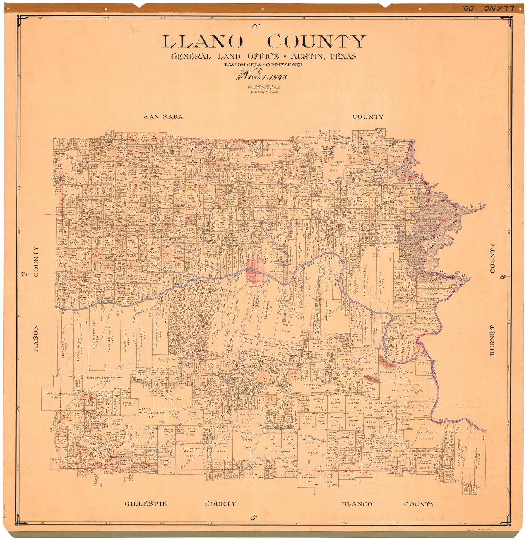
Llano County
-
Map/Doc
73224
-
Collection
General Map Collection
-
Object Dates
1943/11/1 (Creation Date)
-
People and Organizations
Texas General Land Office (Publisher)
Bascom Giles (GLO Commissioner)
Tommye Buie (Draftsman)
R.C. Wisdom (Compiler)
-
Counties
Llano
-
Subjects
County
-
Height x Width
44.1 x 42.6 inches
112.0 x 108.2 cm
-
Comments
Hand lettered.
Note on reverse side: "Compilation completed November 1, 1943. Inking completed February 7, 1944. Tracing completed March 20, 1944. Placed in official use March 21, 1944, Replaced [on sticks] by copy June 7, 1946." -
Features
Mica Creek
Kingsland
Pack Saddle Mountain
Honey Creek
Buck Spring Creek
House Mountain
Gold Mine Creek
Grape Creek
Wall Mountain
Colorado River
Hondo Creek
Lost Hollow Creek
Six Mile Creek
Sandy Creek
Legion Creek
Coal Creek
Comanche Creek
Pot Creek
Pecan Creek
Slick Rock Creek
Crab Apple Creek
Walnut Springs
Enchanted Rock
Inks Lake
Babyhead Mountain
Fall Creek
Spring Creek
Flat Fork of Llano River
Wolf Creek
Cold Creek
Buchanan Lake
Little Llano River
King Mountain
Mitchels Creek
Millers Creek
Magill Creek
H&TC
Llano River
Llano
San Fernando Creek
Flag Creek
Oatman Creek
Cat Mountain
Sharp Mountain
Hickory Creek
Elm Creek
Part of: General Map Collection
Hunt County Sketch File 37

Print $4.00
- Digital $50.00
Hunt County Sketch File 37
Size 11.4 x 8.1 inches
Map/Doc 27155
Duval County Sketch File 18

Print $40.00
- Digital $50.00
Duval County Sketch File 18
Size 12.7 x 15.8 inches
Map/Doc 21314
Brewster County Rolled Sketch 102

Print $20.00
- Digital $50.00
Brewster County Rolled Sketch 102
Size 37.0 x 43.4 inches
Map/Doc 8513
Trace of a copy of the map captured at the battle of Resaca de la Palma

Print $20.00
- Digital $50.00
Trace of a copy of the map captured at the battle of Resaca de la Palma
Size 18.3 x 27.6 inches
Map/Doc 73053
Liberty County Sketch File 26

Print $10.00
- Digital $50.00
Liberty County Sketch File 26
1859
Size 8.3 x 9.2 inches
Map/Doc 29943
Navarro County Working Sketch 2

Print $20.00
- Digital $50.00
Navarro County Working Sketch 2
1922
Size 21.9 x 22.2 inches
Map/Doc 71232
Howard County Rolled Sketch 2

Print $20.00
- Digital $50.00
Howard County Rolled Sketch 2
1905
Size 27.6 x 23.0 inches
Map/Doc 6232
Mills County Rolled Sketch 2

Print $20.00
- Digital $50.00
Mills County Rolled Sketch 2
1974
Size 24.1 x 22.8 inches
Map/Doc 6780
Haskell County Sketch File 12

Print $20.00
- Digital $50.00
Haskell County Sketch File 12
1881
Size 18.8 x 23.6 inches
Map/Doc 11741
Nolan County Working Sketch 4

Print $20.00
- Digital $50.00
Nolan County Working Sketch 4
1948
Size 21.6 x 28.9 inches
Map/Doc 71295
Map of Tom Green County

Print $40.00
- Digital $50.00
Map of Tom Green County
1892
Size 43.2 x 48.3 inches
Map/Doc 63070
Limestone County Sketch File 20

Print $44.00
- Digital $50.00
Limestone County Sketch File 20
1922
Size 11.2 x 8.5 inches
Map/Doc 30195
You may also like
Leon County Working Sketch 20

Print $20.00
- Digital $50.00
Leon County Working Sketch 20
1963
Size 37.8 x 38.2 inches
Map/Doc 70419
Potter County Working Sketch 4

Print $20.00
- Digital $50.00
Potter County Working Sketch 4
1920
Size 41.9 x 34.1 inches
Map/Doc 71664
Roberts County Working Sketch 27

Print $20.00
- Digital $50.00
Roberts County Working Sketch 27
1982
Size 26.6 x 29.4 inches
Map/Doc 63553
San Jacinto County Working Sketch 45

Print $20.00
- Digital $50.00
San Jacinto County Working Sketch 45
1986
Size 41.0 x 46.7 inches
Map/Doc 63759
Reagan County Sketch File 15

Print $4.00
- Digital $50.00
Reagan County Sketch File 15
1931
Size 8.0 x 13.3 inches
Map/Doc 35000
Andrews County Rolled Sketch 40

Print $20.00
- Digital $50.00
Andrews County Rolled Sketch 40
Size 37.2 x 23.0 inches
Map/Doc 77180
Jefferson County Sketch File 15

Print $10.00
- Digital $50.00
Jefferson County Sketch File 15
1870
Size 8.6 x 7.6 inches
Map/Doc 28151
Flight Mission No. DCL-5C, Frame 27, Kenedy County

Print $20.00
- Digital $50.00
Flight Mission No. DCL-5C, Frame 27, Kenedy County
1943
Size 18.5 x 22.4 inches
Map/Doc 85839
Chambers County Sketch File 10

Print $4.00
- Digital $50.00
Chambers County Sketch File 10
1869
Size 6.8 x 11.1 inches
Map/Doc 17550
Shackelford County Working Sketch 12

Print $20.00
- Digital $50.00
Shackelford County Working Sketch 12
1998
Size 27.0 x 22.3 inches
Map/Doc 63852
San Augustine County Working Sketch 8

Print $20.00
- Digital $50.00
San Augustine County Working Sketch 8
1935
Size 24.8 x 35.0 inches
Map/Doc 63695
Double Lakes No. 1, T-Ranch

Print $20.00
- Digital $50.00
Double Lakes No. 1, T-Ranch
Size 37.1 x 34.0 inches
Map/Doc 92944