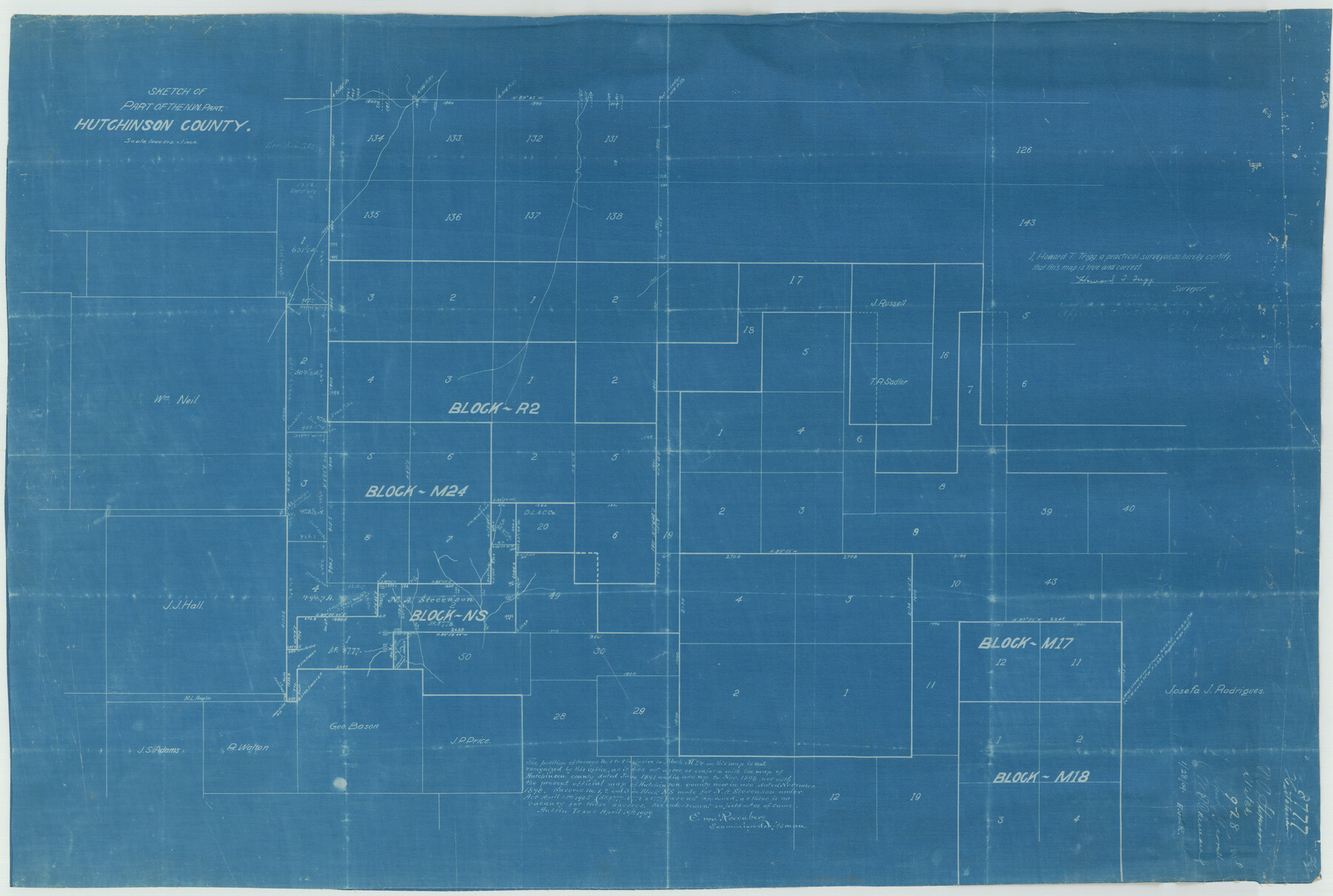
Sketch of part of the NW part, Hutchinson County
-
Map/Doc
75816
-
Collection
Maddox Collection
-
Object Dates
1909/4/19 (Creation Date)
-
People and Organizations
E. von Rosenberg (Draftsman)
Howard T. Trigg (Surveyor/Engineer)
-
Counties
Hutchinson
-
Height x Width
20.9 x 31.2 inches
53.1 x 79.2 cm
-
Medium
blueprint/diazo
-
Scale
1000 varas = 1 inch
Part of: Maddox Collection

Survey of Lots 1, 2, 3, 4 and 5, Block 12G Fair View Park, Austin Texas

Print $20.00
- Digital $50.00
Survey of Lots 1, 2, 3, 4 and 5, Block 12G Fair View Park, Austin Texas
1914
Size 23.1 x 11.0 inches
Map/Doc 83431
[Sketch in Reagan, Irion and Tom Green Counties]
![75551, [Sketch in Reagan, Irion and Tom Green Counties], Maddox Collection](https://historictexasmaps.com/wmedia_w700/maps/75551.tif.jpg)
Print $20.00
- Digital $50.00
[Sketch in Reagan, Irion and Tom Green Counties]
Size 12.5 x 30.1 inches
Map/Doc 75551
Fisher County

Print $20.00
- Digital $50.00
Fisher County
1880
Size 29.4 x 25.3 inches
Map/Doc 75772
Working Sketch in SW cor. of Coleman Co. showing the excess in the surveys fronting on the river and the relative position of surveys north of them according to latest data on file in the Genl. Land Office

Print $20.00
- Digital $50.00
Working Sketch in SW cor. of Coleman Co. showing the excess in the surveys fronting on the river and the relative position of surveys north of them according to latest data on file in the Genl. Land Office
1892
Size 18.8 x 14.1 inches
Map/Doc 441
Survey of a Portion of Lot. No. 1 of Spear League

Print $20.00
- Digital $50.00
Survey of a Portion of Lot. No. 1 of Spear League
1911
Size 12.2 x 24.2 inches
Map/Doc 477
Capitol Land Reservation

Print $40.00
- Digital $50.00
Capitol Land Reservation
1882
Size 51.4 x 18.0 inches
Map/Doc 76175
Lynn County, Texas

Print $20.00
- Digital $50.00
Lynn County, Texas
1883
Size 19.0 x 18.3 inches
Map/Doc 739
Map Representing the Original Locations of Various Surveys Deliniated Thereon

Print $40.00
- Digital $50.00
Map Representing the Original Locations of Various Surveys Deliniated Thereon
1890
Size 40.8 x 62.0 inches
Map/Doc 469
Map of Lands in King County, Texas owned and leased by the Louisville Land and Cattle Company

Print $20.00
- Digital $50.00
Map of Lands in King County, Texas owned and leased by the Louisville Land and Cattle Company
Size 32.1 x 25.9 inches
Map/Doc 5070
Sketch from the map of Bailey Co.

Print $2.00
- Digital $50.00
Sketch from the map of Bailey Co.
Size 8.4 x 7.6 inches
Map/Doc 464
Gillespie County, Texas

Print $20.00
- Digital $50.00
Gillespie County, Texas
1879
Size 21.2 x 26.9 inches
Map/Doc 547
You may also like
Washington County Sketch File 5

Print $4.00
- Digital $50.00
Washington County Sketch File 5
Size 8.0 x 7.0 inches
Map/Doc 39652
Tyler County Sketch File 27

Print $6.00
- Digital $50.00
Tyler County Sketch File 27
1956
Size 14.5 x 8.8 inches
Map/Doc 38696
Schleicher County Working Sketch 26

Print $20.00
- Digital $50.00
Schleicher County Working Sketch 26
1962
Size 27.3 x 30.0 inches
Map/Doc 63828
Topographic Map, Reynard Sheet, Trinity River; Houston and Leon Counties

Print $20.00
- Digital $50.00
Topographic Map, Reynard Sheet, Trinity River; Houston and Leon Counties
1925
Size 45.6 x 41.4 inches
Map/Doc 2469
Flight Mission No. CRC-3R, Frame 39, Chambers County

Print $20.00
- Digital $50.00
Flight Mission No. CRC-3R, Frame 39, Chambers County
1956
Size 18.6 x 22.4 inches
Map/Doc 84812
Young County Sketch File 16

Print $4.00
- Digital $50.00
Young County Sketch File 16
1896
Size 10.3 x 8.5 inches
Map/Doc 40880
Pecos County Sketch File 32

Print $20.00
- Digital $50.00
Pecos County Sketch File 32
1934
Size 23.2 x 24.3 inches
Map/Doc 12175
Port Facilities at Galveston, Tex.

Print $20.00
- Digital $50.00
Port Facilities at Galveston, Tex.
Size 14.1 x 37.5 inches
Map/Doc 97173
Dickens County Sketch File 2a

Print $4.00
- Digital $50.00
Dickens County Sketch File 2a
1884
Size 14.2 x 8.9 inches
Map/Doc 20950
Montgomery County Sketch File 37

Print $6.00
- Digital $50.00
Montgomery County Sketch File 37
Size 12.6 x 8.2 inches
Map/Doc 31916
Webb County Rolled Sketch 78

Print $20.00
- Digital $50.00
Webb County Rolled Sketch 78
2011
Size 33.1 x 24.6 inches
Map/Doc 90052
Map of Red River County

Print $20.00
- Digital $50.00
Map of Red River County
1842
Size 25.2 x 23.1 inches
Map/Doc 78369