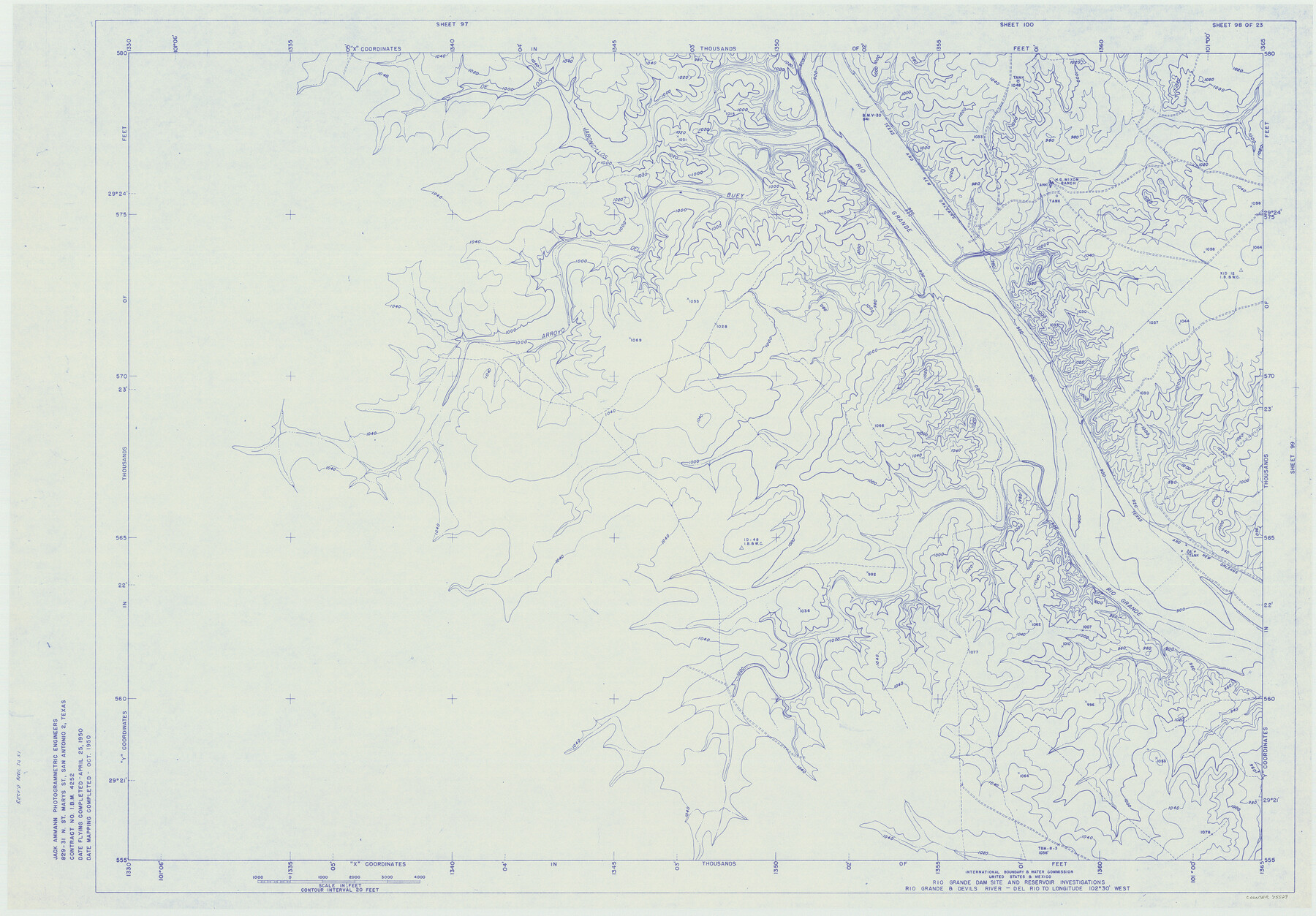
Amistad International Reservoir on Rio Grande 98
Rio Grande Dam Site and Reservoir Investigations
-
Map/Doc
75529
-
Collection
General Map Collection
-
Object Dates
1950 (Creation Date)
-
People and Organizations
International Boundary and Water Commission (Publisher)
Jack Ammann Photogrammetric Engineers (Surveyor/Engineer)
-
Counties
Val Verde
-
Subjects
Texas Boundaries Topographic
-
Height x Width
28.5 x 40.9 inches
72.4 x 103.9 cm
-
Medium
blueline
-
Comments
Rio Grande and Devil's River - Del Rio to Longitude 102 degrees 30 minutes West.
Part of: General Map Collection
Map of the Rio Grande & Eagle Pass Ry. from Sections 21-25 9/10 Inclusive, Webb County

Print $40.00
- Digital $50.00
Map of the Rio Grande & Eagle Pass Ry. from Sections 21-25 9/10 Inclusive, Webb County
1909
Size 25.8 x 55.4 inches
Map/Doc 64658
Tarrant County Boundary File 82

Print $22.00
- Digital $50.00
Tarrant County Boundary File 82
Size 8.9 x 7.0 inches
Map/Doc 59173
Real County Working Sketch 46

Print $20.00
- Digital $50.00
Real County Working Sketch 46
1956
Size 21.2 x 18.9 inches
Map/Doc 71938
Bell County Working Sketch 12

Print $20.00
- Digital $50.00
Bell County Working Sketch 12
1956
Size 17.2 x 22.0 inches
Map/Doc 67352
Carta Orografica

Print $20.00
- Digital $50.00
Carta Orografica
Size 26.0 x 34.4 inches
Map/Doc 96802
Navigation Maps of Gulf Intracoastal Waterway, Port Arthur to Brownsville, Texas

Print $4.00
- Digital $50.00
Navigation Maps of Gulf Intracoastal Waterway, Port Arthur to Brownsville, Texas
1951
Size 16.6 x 21.5 inches
Map/Doc 65427
Old Miscellaneous File 16

Print $28.00
- Digital $50.00
Old Miscellaneous File 16
1908
Size 9.8 x 2.6 inches
Map/Doc 75457
Harris County Sketch File 18

Print $6.00
- Digital $50.00
Harris County Sketch File 18
1860
Size 8.0 x 3.4 inches
Map/Doc 25363
Briscoe County Sketch File F

Print $40.00
- Digital $50.00
Briscoe County Sketch File F
1917
Size 20.9 x 19.3 inches
Map/Doc 76756
Webb County Working Sketch 41

Print $20.00
- Digital $50.00
Webb County Working Sketch 41
1941
Size 15.7 x 18.8 inches
Map/Doc 72406
Bee County Working Sketch 6

Print $20.00
- Digital $50.00
Bee County Working Sketch 6
1934
Size 33.8 x 24.1 inches
Map/Doc 67256
Oldham County Sketch File 18

Print $6.00
- Digital $50.00
Oldham County Sketch File 18
1910
Size 8.9 x 8.5 inches
Map/Doc 33272
You may also like
[Val Verde County]
![63096, [Val Verde County], General Map Collection](https://historictexasmaps.com/wmedia_w700/maps/63096.tif.jpg)
Print $20.00
- Digital $50.00
[Val Verde County]
1898
Size 42.6 x 34.9 inches
Map/Doc 63096
English Field Notes of the Spanish Archives - Book S

English Field Notes of the Spanish Archives - Book S
1835
Map/Doc 96543
Medina County Working Sketch 23

Print $20.00
- Digital $50.00
Medina County Working Sketch 23
Size 43.8 x 43.1 inches
Map/Doc 70938
[T. & N. O. Railroad Company Blocks 2T and 3T]
![91489, [T. & N. O. Railroad Company Blocks 2T and 3T], Twichell Survey Records](https://historictexasmaps.com/wmedia_w700/maps/91489-1.tif.jpg)
Print $20.00
- Digital $50.00
[T. & N. O. Railroad Company Blocks 2T and 3T]
Size 24.4 x 8.8 inches
Map/Doc 91489
Map Representing the Original Locations of Various Surveys Deliniated Thereon

Print $40.00
- Digital $50.00
Map Representing the Original Locations of Various Surveys Deliniated Thereon
1890
Size 40.8 x 62.0 inches
Map/Doc 469
Dimmit County

Print $40.00
- Digital $50.00
Dimmit County
1976
Size 42.2 x 48.9 inches
Map/Doc 77265
[Surveys around the Martha Barker survey]
![90235, [Surveys around the Martha Barker survey], Twichell Survey Records](https://historictexasmaps.com/wmedia_w700/maps/90235-1.tif.jpg)
Print $20.00
- Digital $50.00
[Surveys around the Martha Barker survey]
Size 26.8 x 20.2 inches
Map/Doc 90235

[Office Sketch of County School Land surveys in Schleicher County, Texas]
![75770, [Office Sketch of County School Land surveys in Schleicher County, Texas], Maddox Collection](https://historictexasmaps.com/wmedia_w700/maps/75770.tif.jpg)
Print $20.00
- Digital $50.00
[Office Sketch of County School Land surveys in Schleicher County, Texas]
Size 13.1 x 21.0 inches
Map/Doc 75770
Flight Mission No. DQN-4K, Frame 3, Calhoun County

Print $20.00
- Digital $50.00
Flight Mission No. DQN-4K, Frame 3, Calhoun County
1953
Size 18.9 x 22.4 inches
Map/Doc 84368
Midland County

Print $20.00
- Digital $50.00
Midland County
1930
Size 45.7 x 39.6 inches
Map/Doc 66930
Real County Rolled Sketch 18

Print $20.00
- Digital $50.00
Real County Rolled Sketch 18
Size 22.0 x 28.0 inches
Map/Doc 7466