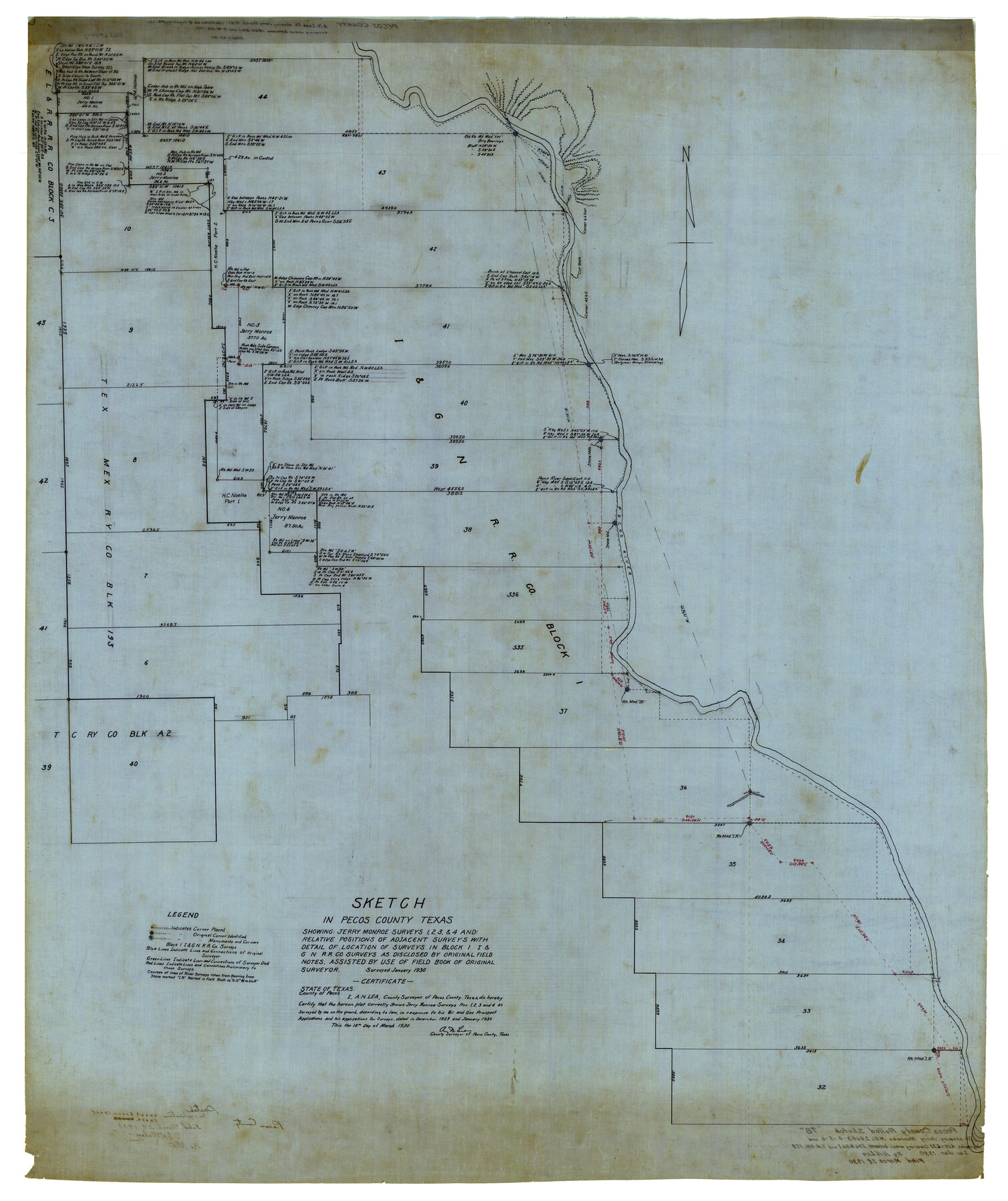
Pecos County Rolled Sketch 78
Sketch in Pecos County Texas showing: Jerry Monroe Surveys 1, 2, 3, & 4 and Relative positions of adjacent surveys with detail of location of Surveys in Block 1 I&GN R.R. Co. Surveys as disclosed by original field notes, assisted by use of field book of
- 
                          Map/Doc
9705
 - 
                            Collection
General Map Collection
 - 
                            Object Dates
1930 (Creation Date)
1930 (File Date)
 - 
                            People and Organizations
A.N. Lea (Surveyor/Engineer)
 - 
                            Counties
Pecos
 - 
                            Subjects
Surveying Rolled Sketch
 - 
                            Height x Width
52.6 x 44.1 inches
133.6 x 112.0 cm
 
Part of: General Map Collection
            Throckmorton County Sketch File 5a


                                            Print $22.00                    
                                             -                         Digital $50.00                                    
                Throckmorton County Sketch File 5a
Size 8.0 x 7.8 inches
                                Map/Doc 38075
            
            Crane County Working Sketch 22


                                            Print $20.00                    
                                             -                         Digital $50.00                                    
                Crane County Working Sketch 22
1961
Size 44.7 x 43.9 inches
                                Map/Doc 68299
            
            Flight Mission No. DQO-11K, Frame 21, Galveston County


                                            Print $20.00                    
                                             -                         Digital $50.00                                    
                Flight Mission No. DQO-11K, Frame 21, Galveston County
1952
Size 18.6 x 19.7 inches
                                Map/Doc 85218
            
            Cooke County Working Sketch 9


                                            Print $20.00                    
                                             -                         Digital $50.00                                    
                Cooke County Working Sketch 9
1940
Size 40.6 x 27.9 inches
                                Map/Doc 68246
            
            Palo Pinto County Boundary File 3


                                            Print $58.00                    
                                             -                         Digital $50.00                                    
                Palo Pinto County Boundary File 3
Size 14.3 x 8.7 inches
                                Map/Doc 57800
            
            Andrews County Working Sketch 8


                                            Print $20.00                    
                                             -                         Digital $50.00                                    
                Andrews County Working Sketch 8
1954
Size 18.2 x 14.9 inches
                                Map/Doc 67054
            
            Bandera County Working Sketch 29


                                            Print $20.00                    
                                             -                         Digital $50.00                                    
                Bandera County Working Sketch 29
1954
Size 19.6 x 19.3 inches
                                Map/Doc 67625
            
            Southern Part of Laguna Madre


                                            Print $20.00                    
                                             -                         Digital $50.00                                    
                Southern Part of Laguna Madre
1985
Size 45.3 x 36.6 inches
                                Map/Doc 73547
            
            Navigation Maps of Gulf Intracoastal Waterway, Port Arthur to Brownsville, Texas


                                            Print $4.00                    
                                             -                         Digital $50.00                                    
                Navigation Maps of Gulf Intracoastal Waterway, Port Arthur to Brownsville, Texas
1951
Size 16.6 x 21.5 inches
                                Map/Doc 65436
            
            McMullen County Sketch File 9


                                            Print $4.00                    
                                             -                         Digital $50.00                                    
                McMullen County Sketch File 9
1876
Size 14.4 x 8.4 inches
                                Map/Doc 31351
            
            Bowie County Sketch File 3


                                            Print $40.00                    
                                             -                         Digital $50.00                                    
                Bowie County Sketch File 3
Size 25.7 x 38.1 inches
                                Map/Doc 10941
            You may also like
            Guadalupe County Sketch File 15e


                                            Print $6.00                    
                                             -                         Digital $50.00                                    
                Guadalupe County Sketch File 15e
Size 9.9 x 8.1 inches
                                Map/Doc 24707
            
            Anderson County Sketch File 29


                                            Print $4.00                    
                                             -                         Digital $50.00                                    
                Anderson County Sketch File 29
1873
Size 10.4 x 8.2 inches
                                Map/Doc 12814
            
            Johnson County Boundary File 2


                                            Print $56.00                    
                                             -                         Digital $50.00                                    
                Johnson County Boundary File 2
Size 9.5 x 34.9 inches
                                Map/Doc 55556
            
            Sketch from Oldham County


                                            Print $20.00                    
                                             -                         Digital $50.00                                    
                Sketch from Oldham County
1901
Size 23.5 x 20.9 inches
                                Map/Doc 91404
            
            Geological Map of the Great East Texas Oil Fields


                                            Print $20.00                    
                                             -                         Digital $50.00                                    
                Geological Map of the Great East Texas Oil Fields
Size 22.6 x 11.7 inches
                                Map/Doc 94271
            
            La Salle County Boundary File 57a


                                            Print $6.00                    
                                             -                         Digital $50.00                                    
                La Salle County Boundary File 57a
Size 14.3 x 8.8 inches
                                Map/Doc 56255
            
            Stanton Acres, a Subdivision of Tracts 2 and 3, Block 1; and Tract 1, Block 2]


                                            Print $3.00                    
                                             -                         Digital $50.00                                    
                Stanton Acres, a Subdivision of Tracts 2 and 3, Block 1; and Tract 1, Block 2]
Size 9.4 x 11.8 inches
                                Map/Doc 91336
            
            Map Showing Colonel A.W. Doniphan's Route through the States of New Mexico, Chihuahua and Coahuila


                                            Print $20.00                    
                                    
                Map Showing Colonel A.W. Doniphan's Route through the States of New Mexico, Chihuahua and Coahuila
1847
Size 16.9 x 14.0 inches
                                Map/Doc 79729
            
            [Blocks G and H, and vicinity]


                                            Print $20.00                    
                                             -                         Digital $50.00                                    
                [Blocks G and H, and vicinity]
1915
Size 18.4 x 12.4 inches
                                Map/Doc 92671
            
            Clay County Sketch File 28


                                            Print $20.00                    
                                             -                         Digital $50.00                                    
                Clay County Sketch File 28
Size 25.3 x 31.2 inches
                                Map/Doc 11090
            
            Cooke County Working Sketch 5


                                            Print $20.00                    
                                             -                         Digital $50.00                                    
                Cooke County Working Sketch 5
1928
Size 16.1 x 17.2 inches
                                Map/Doc 68242