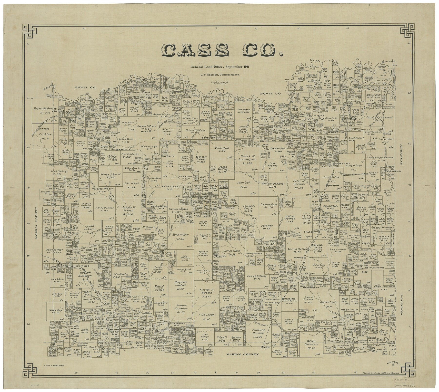
Cass Co.
-
Map/Doc
66749
-
Collection
General Map Collection
-
Object Dates
9/1911 (Creation Date)
-
People and Organizations
Texas General Land Office (Publisher)
James K. Duke (Draftsman)
J.T. Robison (GLO Commissioner)
James K. Duke (Compiler)
-
Counties
Cass
-
Subjects
County
-
Height x Width
38.7 x 43.2 inches
98.3 x 109.7 cm
-
Comments
Traced in September 1935 by J. Woodland.
Part of: General Map Collection
Guadalupe County Sketch File 15f

Print $10.00
- Digital $50.00
Guadalupe County Sketch File 15f
Size 12.7 x 8.2 inches
Map/Doc 24710
Proceedings of The International (Water) Boundary Commission United States and Mexico Treaties of 1884 and 1889, Volume 1

Proceedings of The International (Water) Boundary Commission United States and Mexico Treaties of 1884 and 1889, Volume 1
Map/Doc 83144
Washington County Sketch File 6

Print $20.00
- Digital $50.00
Washington County Sketch File 6
1901
Size 24.7 x 26.0 inches
Map/Doc 12602
Childress County Rolled Sketch 5A

Print $20.00
- Digital $50.00
Childress County Rolled Sketch 5A
Size 32.9 x 21.9 inches
Map/Doc 5440
Kaufman County Working Sketch 9

Print $20.00
- Digital $50.00
Kaufman County Working Sketch 9
1988
Size 35.9 x 29.8 inches
Map/Doc 66672
Flight Mission No. DCL-7C, Frame 107, Kenedy County

Print $20.00
- Digital $50.00
Flight Mission No. DCL-7C, Frame 107, Kenedy County
1943
Size 18.4 x 22.2 inches
Map/Doc 86072
Flight Mission No. DCL-7C, Frame 117, Kenedy County

Print $20.00
- Digital $50.00
Flight Mission No. DCL-7C, Frame 117, Kenedy County
1943
Size 18.4 x 22.3 inches
Map/Doc 86082
Austin County Boundary File 4

Print $10.00
- Digital $50.00
Austin County Boundary File 4
Size 14.1 x 8.6 inches
Map/Doc 50244
Edwards County Rolled Sketch 33

Print $20.00
- Digital $50.00
Edwards County Rolled Sketch 33
1890
Size 25.0 x 25.8 inches
Map/Doc 5815
Victoria County Working Sketch Graphic Index

Print $20.00
- Digital $50.00
Victoria County Working Sketch Graphic Index
1921
Size 47.0 x 39.0 inches
Map/Doc 76728
Val Verde County Sketch File 15 and 16

Print $60.00
- Digital $50.00
Val Verde County Sketch File 15 and 16
1883
Size 8.9 x 4.1 inches
Map/Doc 39207
Nolan County Working Sketch 7

Print $20.00
- Digital $50.00
Nolan County Working Sketch 7
1954
Size 33.9 x 24.3 inches
Map/Doc 71298
You may also like
Flight Mission No. BRE-4P, Frame 166, Nueces County

Print $20.00
- Digital $50.00
Flight Mission No. BRE-4P, Frame 166, Nueces County
1956
Size 18.5 x 22.4 inches
Map/Doc 86829
Bastrop County Sketch File 5

Print $4.00
- Digital $50.00
Bastrop County Sketch File 5
Size 8.1 x 10.2 inches
Map/Doc 14048
Sketch of surveys on Deer Creek, Milam District

Print $2.00
- Digital $50.00
Sketch of surveys on Deer Creek, Milam District
1846
Size 7.8 x 10.9 inches
Map/Doc 76046
Bell County Sketch File 15

Print $4.00
- Digital $50.00
Bell County Sketch File 15
1861
Size 6.4 x 8.0 inches
Map/Doc 14394
Kinney County Sketch File E

Print $10.00
- Digital $50.00
Kinney County Sketch File E
1885
Size 10.7 x 8.1 inches
Map/Doc 29124
Midland County Working Sketch 25

Print $40.00
- Digital $50.00
Midland County Working Sketch 25
1957
Size 58.3 x 49.1 inches
Map/Doc 71006
Map of Hill County

Print $40.00
- Digital $50.00
Map of Hill County
1884
Size 80.0 x 35.2 inches
Map/Doc 93379
Liberty County Rolled Sketch J

Print $20.00
- Digital $50.00
Liberty County Rolled Sketch J
1943
Size 29.1 x 38.0 inches
Map/Doc 10646
Crane County Working Sketch Graphic Index, Sheet B

Print $20.00
- Digital $50.00
Crane County Working Sketch Graphic Index, Sheet B
1945
Size 44.8 x 33.6 inches
Map/Doc 76508
Brewster County Sketch File NS-4d

Print $8.00
- Digital $50.00
Brewster County Sketch File NS-4d
Size 14.0 x 8.7 inches
Map/Doc 15961
Block 10, Deshazo, Borden County

Print $20.00
- Digital $50.00
Block 10, Deshazo, Borden County
Size 18.3 x 25.5 inches
Map/Doc 92127
[F. W. & D. C. Ry. Co. Alignment and Right of Way Map, Clay County]
![64737, [F. W. & D. C. Ry. Co. Alignment and Right of Way Map, Clay County], General Map Collection](https://historictexasmaps.com/wmedia_w700/maps/64737-GC.tif.jpg)
Print $20.00
- Digital $50.00
[F. W. & D. C. Ry. Co. Alignment and Right of Way Map, Clay County]
1927
Size 18.6 x 11.8 inches
Map/Doc 64737