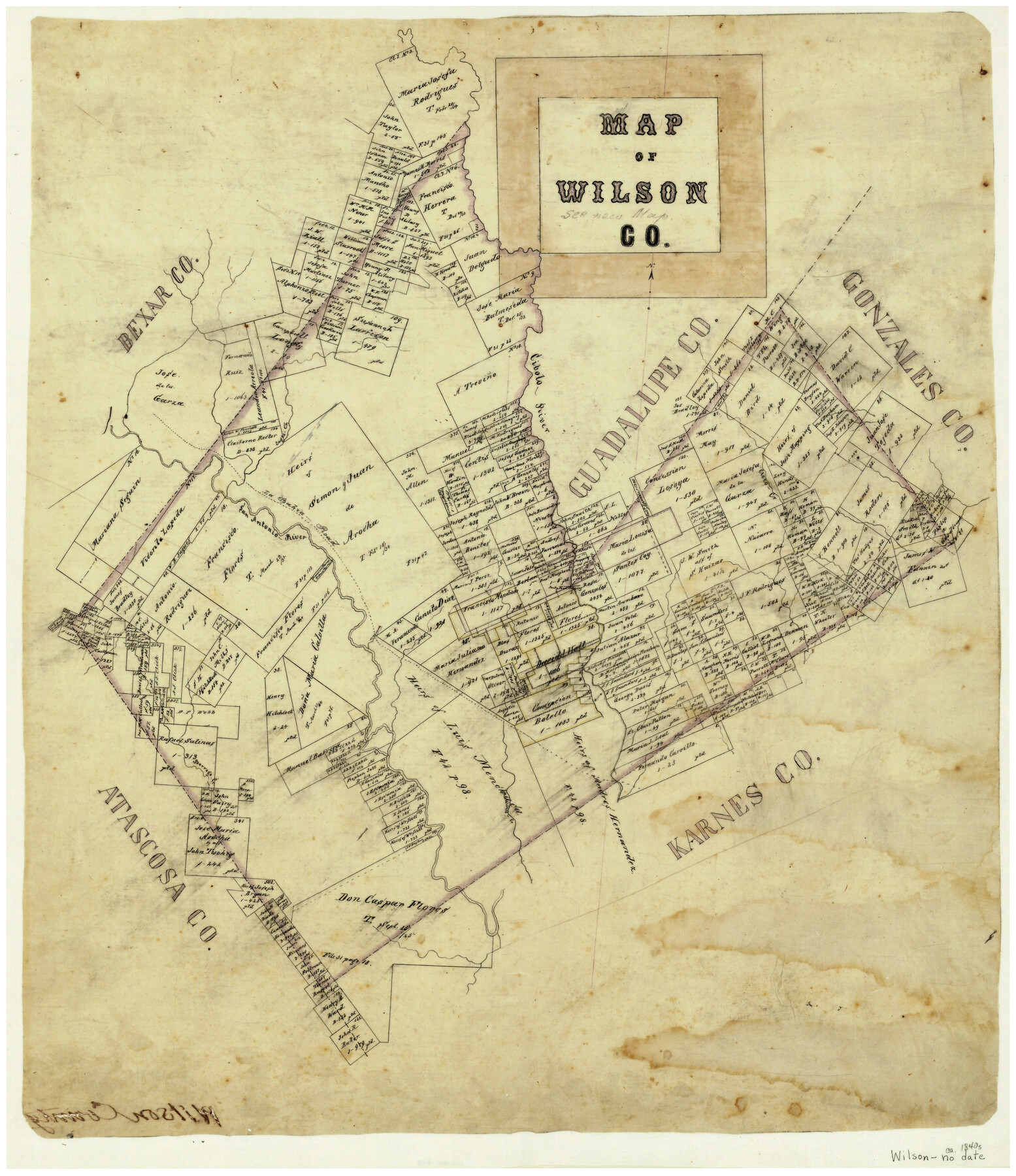
Map of Wilson County
-
Map/Doc
4154
-
Collection
General Map Collection
-
Object Dates
1840 (Creation Date)
-
Counties
Wilson
-
Subjects
County
-
Height x Width
24.4 x 21.0 inches
62.0 x 53.3 cm
-
Features
Eagle Creek
Cibolo River
Cleto Creek
La Bahia Road
San Antonio River
Borrego Creek
Marvelinos Creek
Rocky Ford Crossing
Bazarlia Creek
Part of: General Map Collection
Travis County Working Sketch 10

Print $20.00
- Digital $50.00
Travis County Working Sketch 10
1918
Size 24.7 x 16.3 inches
Map/Doc 69394
Hidalgo County Sketch File 1

Print $40.00
- Digital $50.00
Hidalgo County Sketch File 1
Size 20.2 x 12.0 inches
Map/Doc 26392
Tarrant County Sketch File 1a

Print $4.00
- Digital $50.00
Tarrant County Sketch File 1a
1851
Size 10.2 x 7.8 inches
Map/Doc 37670
Galveston County NRC Article 33.136 Location Key Sheet

Print $20.00
- Digital $50.00
Galveston County NRC Article 33.136 Location Key Sheet
1994
Size 27.0 x 21.8 inches
Map/Doc 77019
Ashburn's San Antonio City Map

Ashburn's San Antonio City Map
1951
Size 24.5 x 19.5 inches
Map/Doc 97144
El Paso County Sketch File 3

Print $98.00
- Digital $50.00
El Paso County Sketch File 3
1879
Size 13.0 x 8.3 inches
Map/Doc 21909
Harris County Rolled Sketch 93

Print $20.00
- Digital $50.00
Harris County Rolled Sketch 93
1983
Size 45.0 x 40.2 inches
Map/Doc 9142
Loving County Sketch File 8

Print $44.00
- Digital $50.00
Loving County Sketch File 8
2002
Size 11.2 x 8.7 inches
Map/Doc 76377
Callahan County Rolled Sketch 26

Print $20.00
- Digital $50.00
Callahan County Rolled Sketch 26
2010
Size 30.6 x 24.6 inches
Map/Doc 93453
Right of Way and Track Map, International & Gt. Northern Ry. Operated by the International & Gt. Northern Ry. Co. Gulf Division, Mineola Branch

Print $40.00
- Digital $50.00
Right of Way and Track Map, International & Gt. Northern Ry. Operated by the International & Gt. Northern Ry. Co. Gulf Division, Mineola Branch
1917
Size 25.5 x 116.7 inches
Map/Doc 64701
Blanco County Working Sketch 10

Print $20.00
- Digital $50.00
Blanco County Working Sketch 10
1938
Size 28.3 x 25.8 inches
Map/Doc 67370
International boundary between the United States and Mexico in the Rio Grande and Colorado River delineated in accordance with the Treaty of November 23, 1970 - Volume 1

International boundary between the United States and Mexico in the Rio Grande and Colorado River delineated in accordance with the Treaty of November 23, 1970 - Volume 1
1972
Map/Doc 1747
You may also like
Reeves County Working Sketch 52

Print $40.00
- Digital $50.00
Reeves County Working Sketch 52
1977
Size 60.3 x 41.9 inches
Map/Doc 63495
Northeast Part Presidio County

Print $20.00
- Digital $50.00
Northeast Part Presidio County
1973
Size 42.3 x 33.4 inches
Map/Doc 95616
Brewster County Working Sketch 30

Print $40.00
- Digital $50.00
Brewster County Working Sketch 30
1942
Size 44.6 x 59.6 inches
Map/Doc 67564
Outer Continental Shelf Leasing Maps (Louisiana Offshore Operations)

Print $20.00
- Digital $50.00
Outer Continental Shelf Leasing Maps (Louisiana Offshore Operations)
1971
Size 18.7 x 13.9 inches
Map/Doc 76102
Maps of Gulf Intracoastal Waterway, Texas - Sabine River to the Rio Grande and connecting waterways including ship channels

Print $20.00
- Digital $50.00
Maps of Gulf Intracoastal Waterway, Texas - Sabine River to the Rio Grande and connecting waterways including ship channels
1966
Size 14.5 x 22.2 inches
Map/Doc 61974
[Mrs. May Vinson Survey]
![91942, [Mrs. May Vinson Survey], Twichell Survey Records](https://historictexasmaps.com/wmedia_w700/maps/91942-1.tif.jpg)
Print $20.00
- Digital $50.00
[Mrs. May Vinson Survey]
Size 34.0 x 22.8 inches
Map/Doc 91942
Lloyd's Map of the Southern States showing all the Railroads, their Stations & Distances, also the Counties, Towns, Villages, Harbors, Rivers, and Forts

Print $40.00
- Digital $50.00
Lloyd's Map of the Southern States showing all the Railroads, their Stations & Distances, also the Counties, Towns, Villages, Harbors, Rivers, and Forts
1861
Size 39.3 x 54.4 inches
Map/Doc 96556
Fort Bend County Rolled Sketch P

Print $20.00
- Digital $50.00
Fort Bend County Rolled Sketch P
Size 32.2 x 15.5 inches
Map/Doc 5906
Topographical Map of the Rio Grande, Sheet No. 19

Print $20.00
- Digital $50.00
Topographical Map of the Rio Grande, Sheet No. 19
1912
Map/Doc 89543
General Highway Map, Blanco County, Texas

Print $20.00
General Highway Map, Blanco County, Texas
1940
Size 25.0 x 18.5 inches
Map/Doc 79020
Brewster County Sketch File N-24

Print $40.00
- Digital $50.00
Brewster County Sketch File N-24
Size 23.9 x 16.4 inches
Map/Doc 10970
McMullen County Sketch File 44

Print $6.00
- Digital $50.00
McMullen County Sketch File 44
1942
Size 14.2 x 8.8 inches
Map/Doc 31426