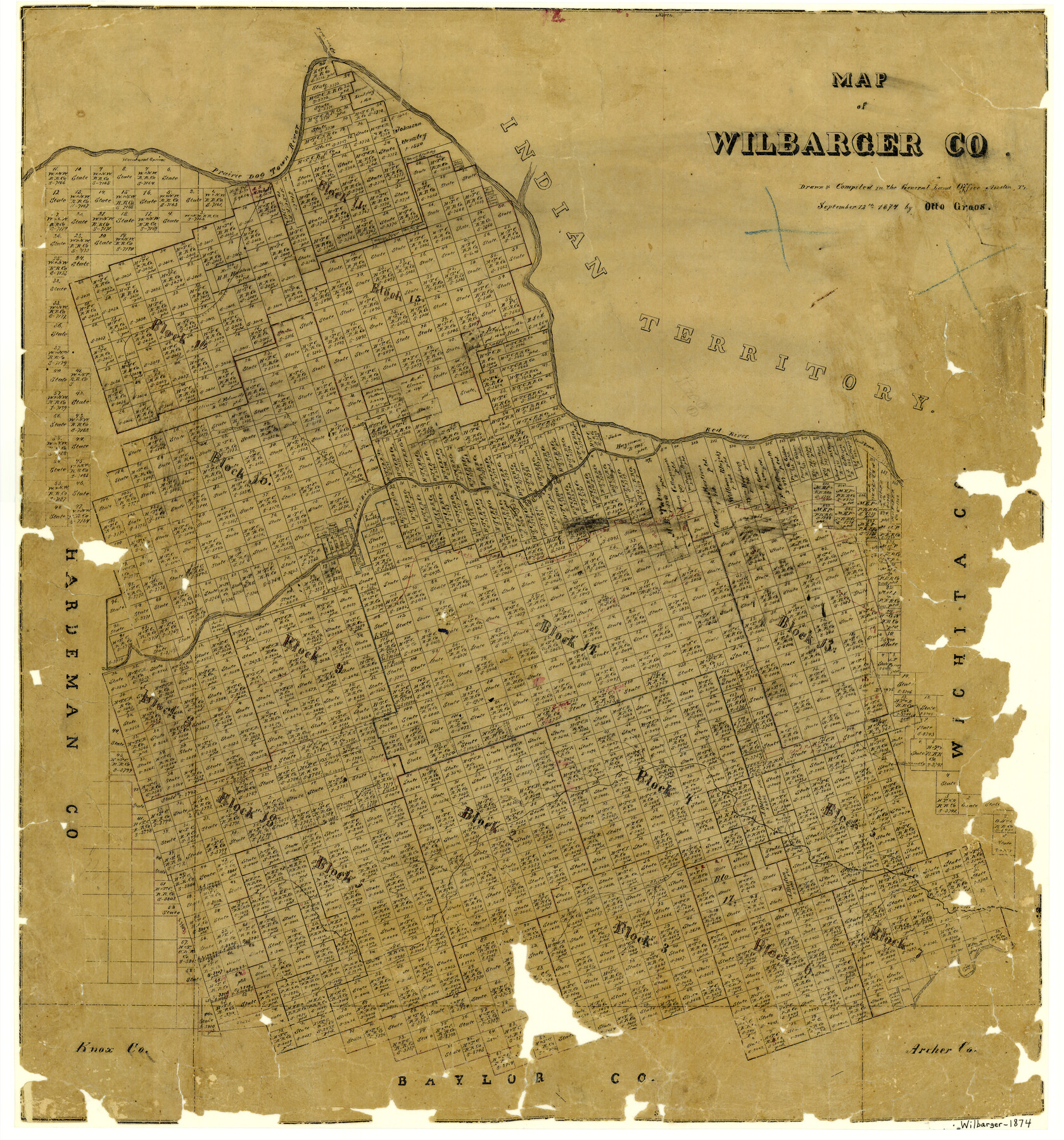
Map of Wilbarger County
-
Map/Doc
4147
-
Collection
General Map Collection
-
Object Dates
1874/9/12 (Creation Date)
-
People and Organizations
Texas General Land Office (Publisher)
Otto Groos (Draftsman)
Otto Groos (Compiler)
-
Counties
Wilbarger
-
Subjects
County
-
Height x Width
23.8 x 22.2 inches
60.5 x 56.4 cm
-
Features
Wormwood Springs
Prairie Dog Town River
Pracers Creek
Wanderer's Creek
Pease River
Red River
Buffalohead Creek
Emma's Creek
Lilley's Creek
Minna's Creek
Frazer's Creek
Buffalo Creek
FW&DC
Part of: General Map Collection
Galveston County Rolled Sketch S

Print $20.00
- Digital $50.00
Galveston County Rolled Sketch S
1935
Size 36.0 x 46.8 inches
Map/Doc 9088
Marion County Sketch File 8

Print $4.00
- Digital $50.00
Marion County Sketch File 8
1852
Size 10.0 x 8.1 inches
Map/Doc 30575
Cochran County Sketch File 3

Print $4.00
- Digital $50.00
Cochran County Sketch File 3
Size 8.8 x 11.3 inches
Map/Doc 18540
Flight Mission No. CLL-3N, Frame 36, Willacy County

Print $20.00
- Digital $50.00
Flight Mission No. CLL-3N, Frame 36, Willacy County
1954
Size 18.4 x 22.2 inches
Map/Doc 87094
[Map of Val Verde County]
![4110, [Map of Val Verde County], General Map Collection](https://historictexasmaps.com/wmedia_w700/maps/4110-1.tif.jpg)
Print $20.00
- Digital $50.00
[Map of Val Verde County]
1931
Size 36.4 x 24.1 inches
Map/Doc 4110
Galveston County Rolled Sketch 27A

Print $20.00
- Digital $50.00
Galveston County Rolled Sketch 27A
1978
Size 32.2 x 35.5 inches
Map/Doc 5962
Galveston County Sketch File 2

Print $2.00
- Digital $50.00
Galveston County Sketch File 2
1845
Size 8.3 x 11.1 inches
Map/Doc 23349
Culberson County Sketch File 26

Print $8.00
- Digital $50.00
Culberson County Sketch File 26
1949
Size 11.2 x 8.8 inches
Map/Doc 20262
Sabine County Sketch File 6

Print $6.00
Sabine County Sketch File 6
Size 3.4 x 5.8 inches
Map/Doc 35612
Flight Mission No. BRE-2P, Frame 38, Nueces County

Print $20.00
- Digital $50.00
Flight Mission No. BRE-2P, Frame 38, Nueces County
1956
Size 18.7 x 22.7 inches
Map/Doc 86740
Ward County Working Sketch 29

Print $40.00
- Digital $50.00
Ward County Working Sketch 29
1964
Size 49.3 x 26.9 inches
Map/Doc 72335
Guadalupe County Working Sketch 12

Print $20.00
- Digital $50.00
Guadalupe County Working Sketch 12
2005
Size 29.1 x 23.5 inches
Map/Doc 83571
You may also like
[Sketch showing Block M-3]
![91708, [Sketch showing Block M-3], Twichell Survey Records](https://historictexasmaps.com/wmedia_w700/maps/91708-1.tif.jpg)
Print $20.00
- Digital $50.00
[Sketch showing Block M-3]
Size 7.0 x 21.2 inches
Map/Doc 91708
Motley County Sketch File 3 (N)

Print $22.00
- Digital $50.00
Motley County Sketch File 3 (N)
Size 9.1 x 13.0 inches
Map/Doc 31998
Sketch No. 1, Dickens & Motley Cos.

Print $20.00
- Digital $50.00
Sketch No. 1, Dickens & Motley Cos.
1879
Size 17.9 x 15.5 inches
Map/Doc 10761
La Salle County Rolled Sketch 6A

Print $40.00
- Digital $50.00
La Salle County Rolled Sketch 6A
1941
Size 43.5 x 68.2 inches
Map/Doc 10729
Smith County Rolled Sketch 6E1

Print $20.00
- Digital $50.00
Smith County Rolled Sketch 6E1
1966
Size 27.4 x 22.7 inches
Map/Doc 10612
[Drawings of individual counties for Pressler and Langermann's 1879 Map of Texas]
![[Drawings of individual counties for Pressler and Langermann's 1879 Map of Texas]](https://historictexasmaps.com/wmedia_w700/maps/4863.tif.jpg)
Print $20.00
- Digital $50.00
[Drawings of individual counties for Pressler and Langermann's 1879 Map of Texas]
1878
Size 38.8 x 26.8 inches
Map/Doc 4863
Map of Granbury

Print $20.00
- Digital $50.00
Map of Granbury
1960
Size 23.5 x 26.7 inches
Map/Doc 3041
Kimble County Working Sketch 35

Print $20.00
- Digital $50.00
Kimble County Working Sketch 35
1946
Size 24.7 x 32.0 inches
Map/Doc 70103
Marion County Working Sketch 41

Print $40.00
- Digital $50.00
Marion County Working Sketch 41
1996
Size 34.0 x 48.5 inches
Map/Doc 70817
Crane County Sketch File 30

Print $40.00
- Digital $50.00
Crane County Sketch File 30
1933
Size 14.0 x 8.4 inches
Map/Doc 19610
General Highway Map, Wise County, Texas

Print $20.00
General Highway Map, Wise County, Texas
1940
Size 18.2 x 24.8 inches
Map/Doc 79284
Hemphill County Sketch File 3

Print $8.00
- Digital $50.00
Hemphill County Sketch File 3
Size 11.4 x 6.5 inches
Map/Doc 26285