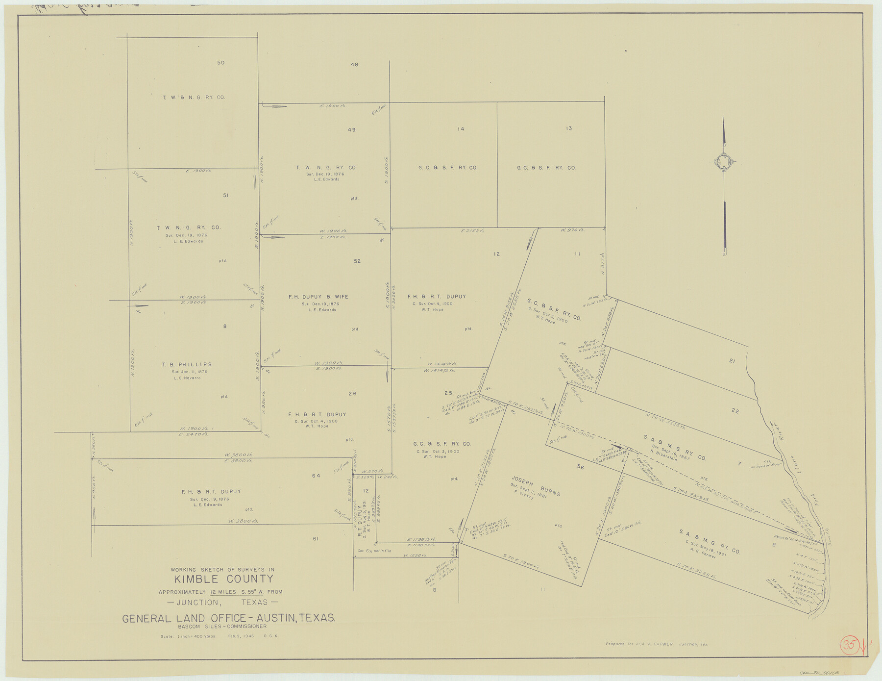
Kimble County Working Sketch 35
-
Map/Doc
70103
-
Collection
General Map Collection
-
Object Dates
2/9/1946 (Creation Date)
-
People and Organizations
Otto G. Kurio (Draftsman)
-
Counties
Kimble
-
Subjects
Surveying Working Sketch
-
Height x Width
24.7 x 32.0 inches
62.7 x 81.3 cm
-
Scale
1" = 400 varas
Part of: General Map Collection
Eastland County Working Sketch 17

Print $20.00
- Digital $50.00
Eastland County Working Sketch 17
1919
Size 18.3 x 16.2 inches
Map/Doc 68798
[Surveys in Austin's Colony near La Bahia Road]
![200, [Surveys in Austin's Colony near La Bahia Road], General Map Collection](https://historictexasmaps.com/wmedia_w700/maps/200.tif.jpg)
Print $20.00
- Digital $50.00
[Surveys in Austin's Colony near La Bahia Road]
1821
Size 10.4 x 20.2 inches
Map/Doc 200
Stonewall County

Print $20.00
- Digital $50.00
Stonewall County
1879
Size 22.7 x 19.1 inches
Map/Doc 4058
Sherman County Rolled Sketch 11

Print $20.00
- Digital $50.00
Sherman County Rolled Sketch 11
Size 34.0 x 35.0 inches
Map/Doc 9930
Galveston County Rolled Sketch 31

Print $20.00
- Digital $50.00
Galveston County Rolled Sketch 31
1979
Size 28.4 x 39.8 inches
Map/Doc 5965
Grimes County Working Sketch 5

Print $40.00
- Digital $50.00
Grimes County Working Sketch 5
1949
Size 43.6 x 83.2 inches
Map/Doc 63296
Palo Pinto County Working Sketch 14

Print $20.00
- Digital $50.00
Palo Pinto County Working Sketch 14
1960
Size 27.2 x 27.4 inches
Map/Doc 71397

Terrell County Working Sketch 51

Print $40.00
- Digital $50.00
Terrell County Working Sketch 51
1958
Size 63.7 x 43.6 inches
Map/Doc 62144
Stonewall County Working Sketch 9

Print $20.00
- Digital $50.00
Stonewall County Working Sketch 9
1950
Size 27.9 x 34.1 inches
Map/Doc 62316
Garza County Sketch File 11

Print $4.00
- Digital $50.00
Garza County Sketch File 11
1901
Size 11.3 x 8.8 inches
Map/Doc 24066

You may also like
St. Louis, Brownsville & Mexico Railway Location Map from Mile 120 to Rio Grande

Print $40.00
- Digital $50.00
St. Louis, Brownsville & Mexico Railway Location Map from Mile 120 to Rio Grande
1905
Size 20.2 x 61.4 inches
Map/Doc 64169
Montgomery County Rolled Sketch 27

Print $20.00
- Digital $50.00
Montgomery County Rolled Sketch 27
Size 34.5 x 34.4 inches
Map/Doc 9536
Shelby County Sketch File 1

Print $4.00
- Digital $50.00
Shelby County Sketch File 1
1848
Size 12.6 x 8.0 inches
Map/Doc 36591
Harris County Boundary File 39 (14)

Print $30.00
- Digital $50.00
Harris County Boundary File 39 (14)
Size 13.2 x 8.1 inches
Map/Doc 54344
Hall County Sketch File 10

Print $20.00
- Digital $50.00
Hall County Sketch File 10
1884
Size 19.6 x 22.1 inches
Map/Doc 11605
Wise County Sketch File 21

Print $4.00
- Digital $50.00
Wise County Sketch File 21
1860
Size 5.6 x 7.9 inches
Map/Doc 40564
Flight Mission No. DIX-8P, Frame 65, Aransas County

Print $20.00
- Digital $50.00
Flight Mission No. DIX-8P, Frame 65, Aransas County
1956
Size 18.7 x 22.4 inches
Map/Doc 83896
Duval County Working Sketch 53

Print $20.00
- Digital $50.00
Duval County Working Sketch 53
1948
Size 34.7 x 37.5 inches
Map/Doc 68777
Brown County Sketch File 12a

Print $8.00
- Digital $50.00
Brown County Sketch File 12a
1870
Size 12.4 x 8.1 inches
Map/Doc 16604
Upton County Sketch File 9

Print $30.00
- Digital $50.00
Upton County Sketch File 9
1913
Size 9.3 x 5.9 inches
Map/Doc 38824
Map of Hays County, Texas

Print $20.00
- Digital $50.00
Map of Hays County, Texas
1880
Size 28.9 x 23.6 inches
Map/Doc 401
Carta General de la República Mexicana Formada para el estudio de la configuracion y division interior de su territorio

Print $20.00
- Digital $50.00
Carta General de la República Mexicana Formada para el estudio de la configuracion y division interior de su territorio
Size 23.2 x 29.4 inches
Map/Doc 95823