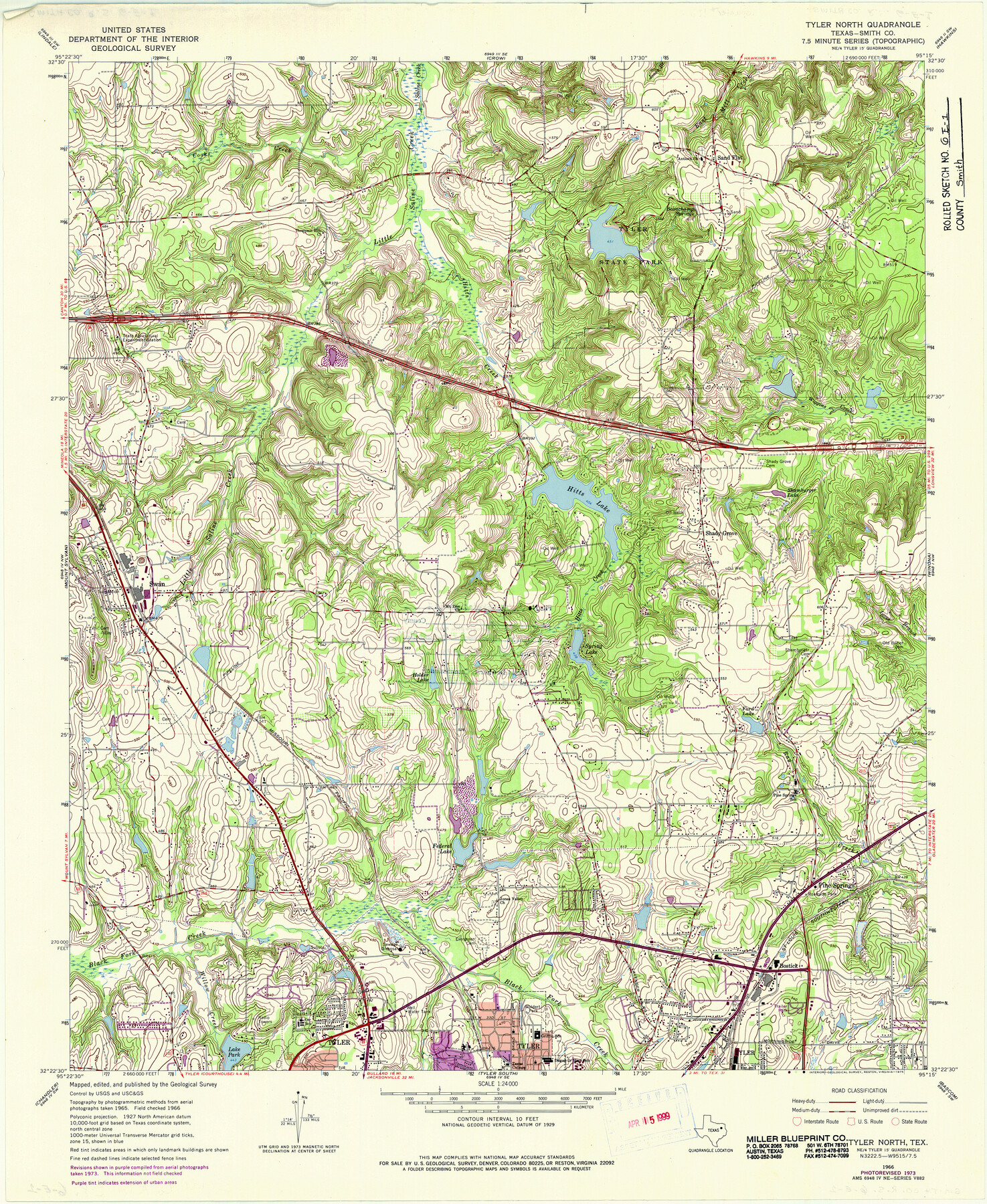
Smith County Rolled Sketch 6E1
Tyler North Quadrangle
-
Map/Doc
10612
-
Collection
General Map Collection
-
Object Dates
1966 (Creation Date)
1973 (Revision Date)
4/15/1999 (File Date)
-
People and Organizations
U.S. Geological Survey (Publisher)
-
Counties
Smith
-
Subjects
Surveying Rolled Sketch
-
Height x Width
27.4 x 22.7 inches
69.6 x 57.7 cm
-
Medium
paper, print
Part of: General Map Collection
Limestone County Sketch File 10

Print $4.00
- Digital $50.00
Limestone County Sketch File 10
Size 8.4 x 9.4 inches
Map/Doc 30171
Flight Mission No. CGI-3N, Frame 129, Cameron County

Print $20.00
- Digital $50.00
Flight Mission No. CGI-3N, Frame 129, Cameron County
1954
Size 18.5 x 22.2 inches
Map/Doc 84602
Terry County Sketch File 1

Print $20.00
- Digital $50.00
Terry County Sketch File 1
1903
Size 25.7 x 23.4 inches
Map/Doc 12428
Midland County Working Sketch 6

Print $20.00
- Digital $50.00
Midland County Working Sketch 6
1950
Size 41.2 x 30.9 inches
Map/Doc 70986
[Sketch for Mineral Application 15559 - Hutchinson County, Canadian River]
![65680, [Sketch for Mineral Application 15559 - Hutchinson County, Canadian River], General Map Collection](https://historictexasmaps.com/wmedia_w700/maps/65680.tif.jpg)
Print $20.00
- Digital $50.00
[Sketch for Mineral Application 15559 - Hutchinson County, Canadian River]
1926
Size 12.0 x 13.2 inches
Map/Doc 65680
Mississippi River to Galveston

Print $40.00
- Digital $50.00
Mississippi River to Galveston
1966
Size 37.0 x 49.8 inches
Map/Doc 69945
McCulloch County Boundary File 1

Print $40.00
- Digital $50.00
McCulloch County Boundary File 1
Size 9.2 x 33.6 inches
Map/Doc 56906
King County Boundary File 5b

Print $25.00
- Digital $50.00
King County Boundary File 5b
Size 8.7 x 6.9 inches
Map/Doc 64924
Flight Mission No. BRE-2P, Frame 36, Nueces County

Print $20.00
- Digital $50.00
Flight Mission No. BRE-2P, Frame 36, Nueces County
1956
Size 18.5 x 22.7 inches
Map/Doc 86738
Map of Bastrop District

Print $20.00
- Digital $50.00
Map of Bastrop District
1847
Size 22.9 x 28.3 inches
Map/Doc 3275
Erath County Working Sketch 11

Print $20.00
- Digital $50.00
Erath County Working Sketch 11
1951
Size 45.1 x 36.2 inches
Map/Doc 69092
Cochran County Sketch File 4

Print $20.00
- Digital $50.00
Cochran County Sketch File 4
1931
Size 24.9 x 22.1 inches
Map/Doc 11100
You may also like
Shelby County Working Sketch 29

Print $20.00
- Digital $50.00
Shelby County Working Sketch 29
2000
Size 19.6 x 29.9 inches
Map/Doc 63883
McMullen County Working Sketch 61

Print $20.00
- Digital $50.00
McMullen County Working Sketch 61
1990
Size 25.2 x 19.8 inches
Map/Doc 70762
Val Verde County Rolled Sketch ECS

Print $20.00
- Digital $50.00
Val Verde County Rolled Sketch ECS
1935
Size 45.6 x 35.6 inches
Map/Doc 10079
Colonial Texas. 1822 to 1834.

Print $20.00
- Digital $50.00
Colonial Texas. 1822 to 1834.
1897
Size 12.8 x 16.3 inches
Map/Doc 93410
Flight Mission No. BRA-16M, Frame 137, Jefferson County

Print $20.00
- Digital $50.00
Flight Mission No. BRA-16M, Frame 137, Jefferson County
1953
Size 18.7 x 22.3 inches
Map/Doc 85743
Limestone County Working Sketch 16

Print $40.00
- Digital $50.00
Limestone County Working Sketch 16
1951
Size 55.7 x 27.8 inches
Map/Doc 70566
Culberson County Sketch File 13

Print $16.00
- Digital $50.00
Culberson County Sketch File 13
1912
Size 11.2 x 8.7 inches
Map/Doc 20146
Lynn County Working Sketch 2

Print $20.00
- Digital $50.00
Lynn County Working Sketch 2
1951
Size 19.8 x 42.5 inches
Map/Doc 70672
Sutton County Rolled Sketch 59

Print $40.00
- Digital $50.00
Sutton County Rolled Sketch 59
1960
Size 86.1 x 42.5 inches
Map/Doc 9977
Crosby County Working Sketch 12

Print $20.00
- Digital $50.00
Crosby County Working Sketch 12
1953
Size 26.0 x 29.8 inches
Map/Doc 68446
Soash-White Industrial Properties

Print $20.00
- Digital $50.00
Soash-White Industrial Properties
Size 37.4 x 24.9 inches
Map/Doc 92776
English Field Notes of the Spanish Archives - Books SAS, DB4, GWS, JWB, and JWB3

English Field Notes of the Spanish Archives - Books SAS, DB4, GWS, JWB, and JWB3
1835
Map/Doc 96551