Yoakum County Sketch File 18
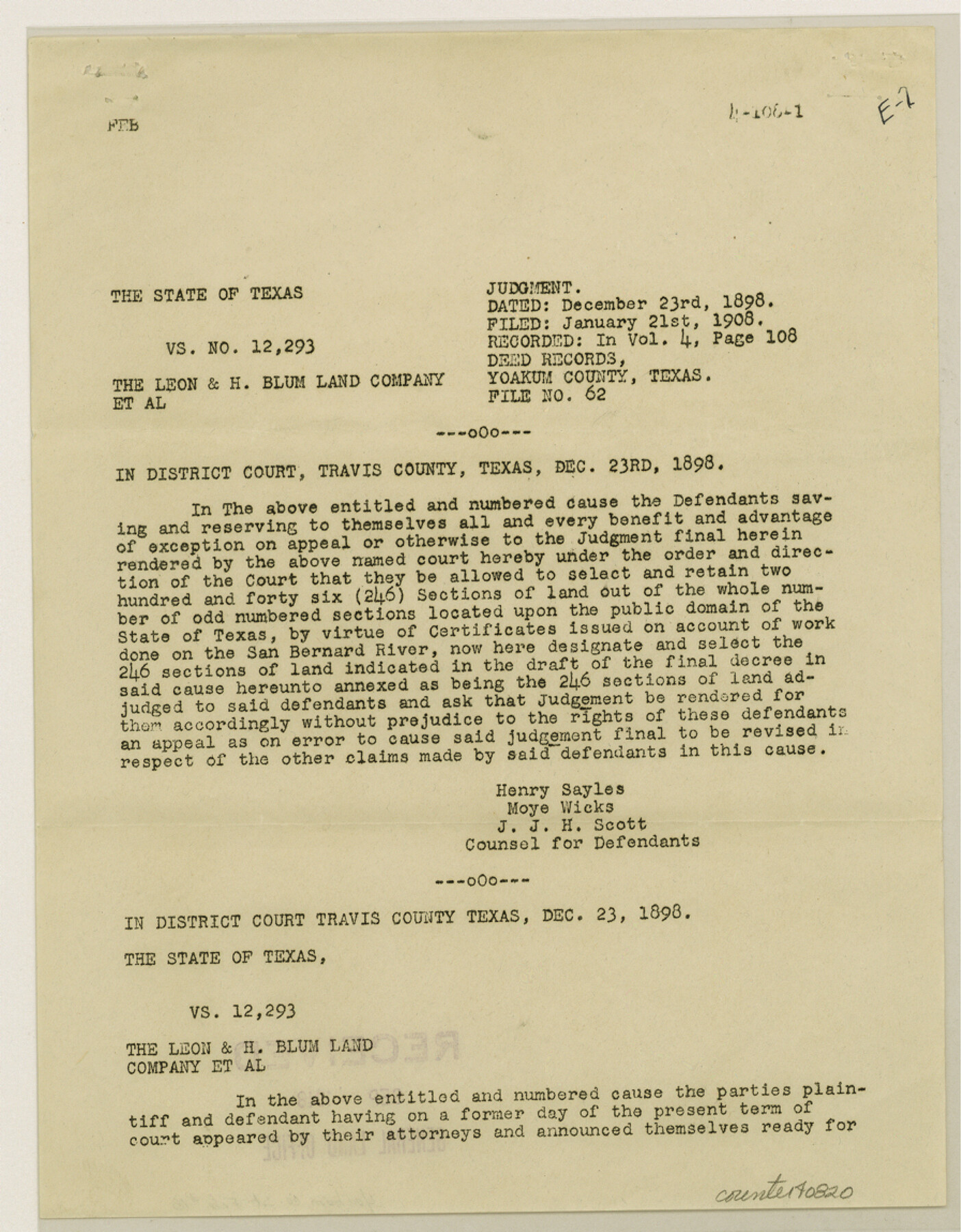
[Judgement no. 12293: The State of Texas vs. The Leon and H. Blum Land Co.]
-
Map/Doc
40820
-
Collection
General Map Collection
-
Object Dates
1898/12/23 (Creation Date)
1948/9/28 (File Date)
1898/12/23 (Creation Date)
1908/1/21 (File Date)
1948/9/28 (File Date)
-
Counties
Yoakum
-
Subjects
Surveying Sketch File
-
Height x Width
11.5 x 9.0 inches
29.2 x 22.9 cm
-
Medium
paper, print
-
Features
San Bernard River
Part of: General Map Collection
Harris County Sketch File 85

Print $20.00
- Digital $50.00
Harris County Sketch File 85
1894
Size 35.7 x 26.0 inches
Map/Doc 11673
Menard County

Print $20.00
- Digital $50.00
Menard County
1942
Size 40.1 x 43.7 inches
Map/Doc 66928
Township No. 4 South Range No. 17 West of the Indian Meridian

Print $20.00
- Digital $50.00
Township No. 4 South Range No. 17 West of the Indian Meridian
1875
Size 19.2 x 24.4 inches
Map/Doc 75164
Glasscock County Sketch File 25

Print $20.00
- Digital $50.00
Glasscock County Sketch File 25
1951
Size 28.8 x 20.6 inches
Map/Doc 11566
Harris County Rolled Sketch 77

Print $20.00
- Digital $50.00
Harris County Rolled Sketch 77
1914
Size 30.0 x 35.6 inches
Map/Doc 6114
Comanche County Working Sketch 14

Print $20.00
- Digital $50.00
Comanche County Working Sketch 14
1960
Size 17.9 x 23.9 inches
Map/Doc 68148
Tanglewood, Station Map-Tracks & Structures-Lands, San Antonio & Aransas Pass Railway Co., Station 4804+179 to Station 4856+179

Print $4.00
- Digital $50.00
Tanglewood, Station Map-Tracks & Structures-Lands, San Antonio & Aransas Pass Railway Co., Station 4804+179 to Station 4856+179
1919
Size 11.7 x 18.6 inches
Map/Doc 62569
Map of Wood County Showing Location of the Texas and Pacific Railway

Print $20.00
- Digital $50.00
Map of Wood County Showing Location of the Texas and Pacific Railway
1872
Size 19.1 x 23.8 inches
Map/Doc 64135
Bailey County Sketch File 5

Print $40.00
- Digital $50.00
Bailey County Sketch File 5
1907
Size 31.9 x 22.8 inches
Map/Doc 10883
McMullen County Working Sketch 44

Print $20.00
- Digital $50.00
McMullen County Working Sketch 44
1981
Size 35.1 x 41.2 inches
Map/Doc 70745
Flight Mission No. DQN-6K, Frame 69, Calhoun County

Print $20.00
- Digital $50.00
Flight Mission No. DQN-6K, Frame 69, Calhoun County
1953
Size 18.6 x 22.1 inches
Map/Doc 84441
Liberty County Sketch File 51

Print $4.00
- Digital $50.00
Liberty County Sketch File 51
Size 7.9 x 13.8 inches
Map/Doc 30017
You may also like
Maps of Gulf Intracoastal Waterway, Texas - Sabine River to the Rio Grande and connecting waterways including ship channels

Print $20.00
- Digital $50.00
Maps of Gulf Intracoastal Waterway, Texas - Sabine River to the Rio Grande and connecting waterways including ship channels
1966
Size 14.5 x 20.8 inches
Map/Doc 61968
Duval County Rolled Sketch 37

Print $20.00
- Digital $50.00
Duval County Rolled Sketch 37
Size 19.8 x 16.5 inches
Map/Doc 5754
Houston County Sketch File 1b

Print $4.00
- Digital $50.00
Houston County Sketch File 1b
1857
Size 8.5 x 7.9 inches
Map/Doc 26744
Cooke County Sketch File 30

Print $4.00
- Digital $50.00
Cooke County Sketch File 30
Size 8.8 x 5.5 inches
Map/Doc 19291
[Capitol Leagues Eastward from Bl, LC2 to H. & T.C. Blk. 44]
![89921, [Capitol Leagues Eastward from Bl, LC2 to H. & T.C. Blk. 44], Twichell Survey Records](https://historictexasmaps.com/wmedia_w700/maps/89921-1.tif.jpg)
Print $40.00
- Digital $50.00
[Capitol Leagues Eastward from Bl, LC2 to H. & T.C. Blk. 44]
Size 64.0 x 41.9 inches
Map/Doc 89921
Upshur County Sketch File 14

Print $10.00
- Digital $50.00
Upshur County Sketch File 14
1936
Size 11.4 x 8.8 inches
Map/Doc 38757
Hudspeth County Rolled Sketch 20

Print $20.00
- Digital $50.00
Hudspeth County Rolled Sketch 20
Size 39.5 x 44.3 inches
Map/Doc 76028
G.C. & S.F. R.R.Co.

Print $20.00
- Digital $50.00
G.C. & S.F. R.R.Co.
1951
Size 18.4 x 13.6 inches
Map/Doc 92837
[Block Y and vicinity]
![91177, [Block Y and vicinity], Twichell Survey Records](https://historictexasmaps.com/wmedia_w700/maps/91177-1.tif.jpg)
Print $20.00
- Digital $50.00
[Block Y and vicinity]
Size 17.7 x 14.6 inches
Map/Doc 91177
[Sketch of Col. Cooke's Military Road expedition from Red River to Austin]
![166, [Sketch of Col. Cooke's Military Road expedition from Red River to Austin], General Map Collection](https://historictexasmaps.com/wmedia_w700/maps/166.tif.jpg)
Print $20.00
- Digital $50.00
[Sketch of Col. Cooke's Military Road expedition from Red River to Austin]
Size 29.4 x 22.9 inches
Map/Doc 166
Guadalupe County Sketch File 7a

Print $4.00
- Digital $50.00
Guadalupe County Sketch File 7a
1873
Size 10.2 x 8.2 inches
Map/Doc 24668
A Map of the Cotton Kingdom and its Dependencies in America

Print $20.00
- Digital $50.00
A Map of the Cotton Kingdom and its Dependencies in America
Size 12.2 x 18.6 inches
Map/Doc 96573