Harris County Sketch File 85
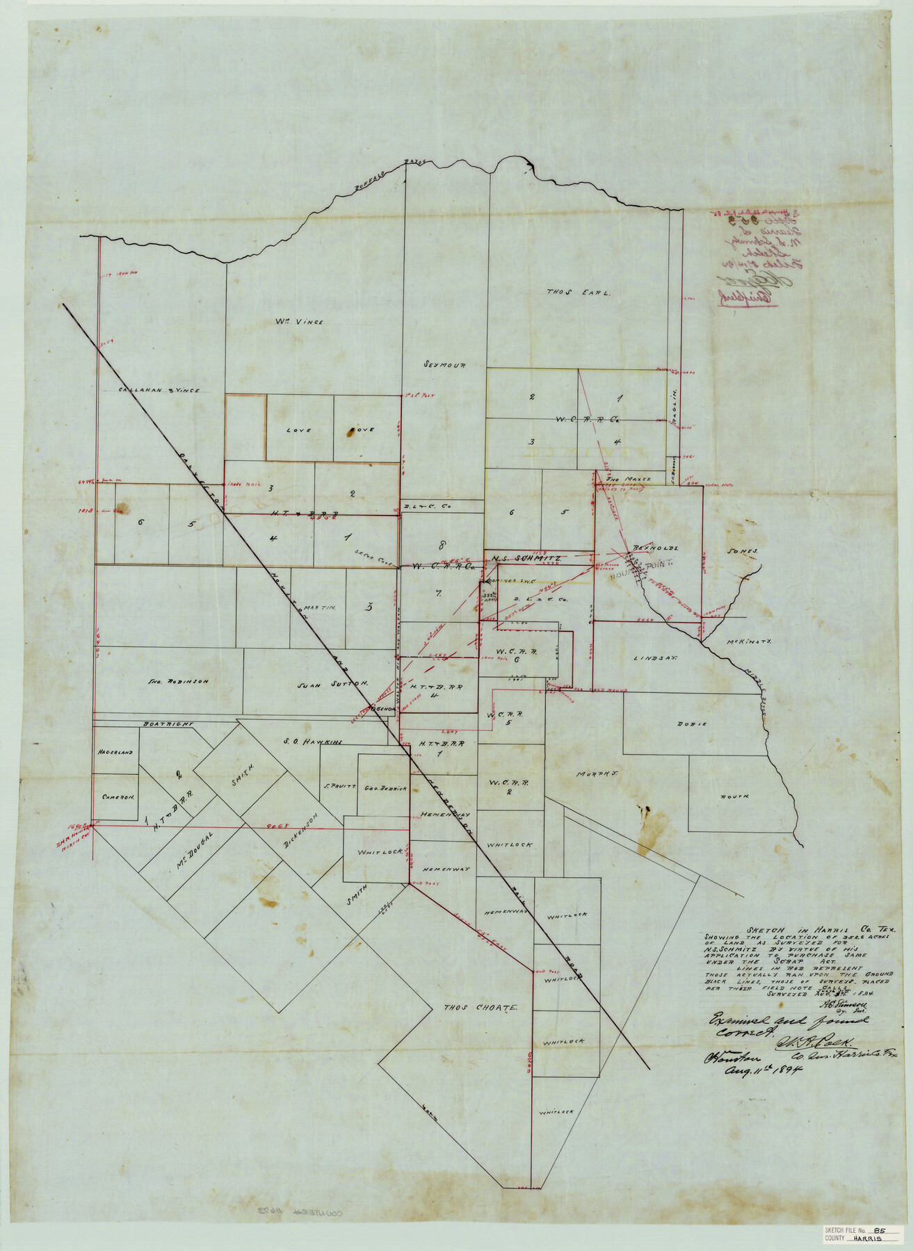
Sketch in Harris Co. Tex. Showing the location of 352.6 acres of land as surveyed for N. S. Schmitz by virtue of his application to purchase same under the Scrap Act
-
Map/Doc
11673
-
Collection
General Map Collection
-
Object Dates
1894/7/31 (Creation Date)
1894/7/31 (Survey Date)
1894/8/11 (Survey Date)
-
People and Organizations
A.E. Stinson (Surveyor/Engineer)
-
Counties
Harris
-
Subjects
Surveying Sketch File
-
Height x Width
35.7 x 26.0 inches
90.7 x 66.0 cm
-
Medium
paper, manuscript
-
Features
Buffalo Bayou
Middle Bayou
GH&H
Genoa
Part of: General Map Collection
Ellis County Working Sketch 4

Print $40.00
- Digital $50.00
Ellis County Working Sketch 4
1997
Size 48.0 x 30.3 inches
Map/Doc 69020
Garza County Sketch File D1

Print $20.00
- Digital $50.00
Garza County Sketch File D1
1901
Size 14.9 x 27.3 inches
Map/Doc 11551
Bexar County Sketch File 43

Print $4.00
- Digital $50.00
Bexar County Sketch File 43
1882
Size 8.7 x 10.2 inches
Map/Doc 14522
Stephens County Sketch File 11

Print $4.00
- Digital $50.00
Stephens County Sketch File 11
1882
Size 8.8 x 9.1 inches
Map/Doc 37055
Rusk County Working Sketch 29b

Print $20.00
- Digital $50.00
Rusk County Working Sketch 29b
Size 25.8 x 18.1 inches
Map/Doc 63666
Presidio County Working Sketch 54

Print $20.00
- Digital $50.00
Presidio County Working Sketch 54
1955
Size 26.0 x 20.8 inches
Map/Doc 71731
Trinity County Working Sketch 6

Print $20.00
- Digital $50.00
Trinity County Working Sketch 6
1920
Size 19.6 x 14.6 inches
Map/Doc 69454
Flight Mission No. DQN-7K, Frame 6, Calhoun County

Print $20.00
- Digital $50.00
Flight Mission No. DQN-7K, Frame 6, Calhoun County
1953
Size 18.8 x 22.4 inches
Map/Doc 84457
Upshur County Sketch File 1

Print $9.00
- Digital $50.00
Upshur County Sketch File 1
1854
Size 5.5 x 4.5 inches
Map/Doc 38728
Bexar County Boundary File 2

Print $32.00
- Digital $50.00
Bexar County Boundary File 2
Size 8.4 x 4.0 inches
Map/Doc 50518
Hardin County Working Sketch 42

Print $20.00
- Digital $50.00
Hardin County Working Sketch 42
1917
Size 16.2 x 22.1 inches
Map/Doc 63441
Flight Mission No. BQY-15M, Frame 8, Harris County

Print $20.00
- Digital $50.00
Flight Mission No. BQY-15M, Frame 8, Harris County
1953
Size 18.7 x 22.4 inches
Map/Doc 85306
You may also like
[I. & G. N. RR. Co. Block I]
![89828, [I. &G. N. RR. Co. Block I], Twichell Survey Records](https://historictexasmaps.com/wmedia_w700/maps/89828-1.tif.jpg)
Print $20.00
- Digital $50.00
[I. & G. N. RR. Co. Block I]
Size 43.0 x 31.7 inches
Map/Doc 89828
No. 2 Chart of Corpus Christi Pass, Texas

Print $20.00
- Digital $50.00
No. 2 Chart of Corpus Christi Pass, Texas
1878
Size 18.4 x 27.3 inches
Map/Doc 73016
Roberts County Working Sketch 27

Print $20.00
- Digital $50.00
Roberts County Working Sketch 27
1982
Size 26.6 x 29.4 inches
Map/Doc 63553
General Highway Map, Baylor County, Texas

Print $20.00
General Highway Map, Baylor County, Texas
1961
Size 18.3 x 24.8 inches
Map/Doc 79363
Eastland County Rolled Sketch 21

Print $20.00
- Digital $50.00
Eastland County Rolled Sketch 21
1982
Size 40.2 x 44.5 inches
Map/Doc 8827
Flight Mission No. DQN-2K, Frame 78, Calhoun County

Print $20.00
- Digital $50.00
Flight Mission No. DQN-2K, Frame 78, Calhoun County
1953
Size 18.6 x 22.3 inches
Map/Doc 84270
Mitchell County Rolled Sketch 2A

Print $20.00
- Digital $50.00
Mitchell County Rolled Sketch 2A
Size 24.2 x 18.5 inches
Map/Doc 88857
Kendall County Sketch File 28

Print $12.00
- Digital $50.00
Kendall County Sketch File 28
1953
Size 14.3 x 8.9 inches
Map/Doc 28733
Nolan County Sketch File 17

Print $6.00
- Digital $50.00
Nolan County Sketch File 17
1940
Size 17.9 x 10.1 inches
Map/Doc 32487
Water Distribution Seagraves Located in Surveys 10 & 15, Block C-34

Print $20.00
- Digital $50.00
Water Distribution Seagraves Located in Surveys 10 & 15, Block C-34
Size 22.1 x 15.8 inches
Map/Doc 92899
Harris County Working Sketch 5

Print $20.00
- Digital $50.00
Harris County Working Sketch 5
Size 35.1 x 28.0 inches
Map/Doc 65897
Map of Oakhurst

Print $20.00
- Digital $50.00
Map of Oakhurst
1899
Size 23.0 x 32.9 inches
Map/Doc 7556