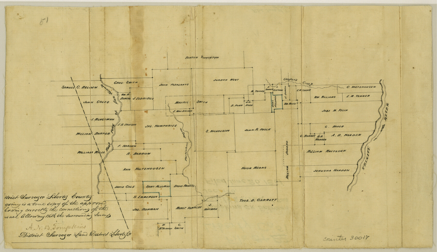
Liberty County Sketch File 51
[Sketch of area between the Trinity River and the East Fork of San Jacinto River in the north part of the county]
-
Map/Doc
30017
-
Collection
General Map Collection
-
Object Dates
6/26/1861 (File Date)
-
People and Organizations
A.N.B. Tompkins (Surveyor/Engineer)
-
Counties
Liberty
-
Subjects
Surveying Sketch File
-
Height x Width
7.9 x 13.8 inches
20.1 x 35.1 cm
-
Medium
paper, manuscript
-
Features
East Fork of San Jacinto River
Tarkinton's Bayou
Caylor's Creek
Trinity River
Part of: General Map Collection
Parker County Sketch File 9

Print $4.00
- Digital $50.00
Parker County Sketch File 9
Size 8.1 x 10.0 inches
Map/Doc 33538
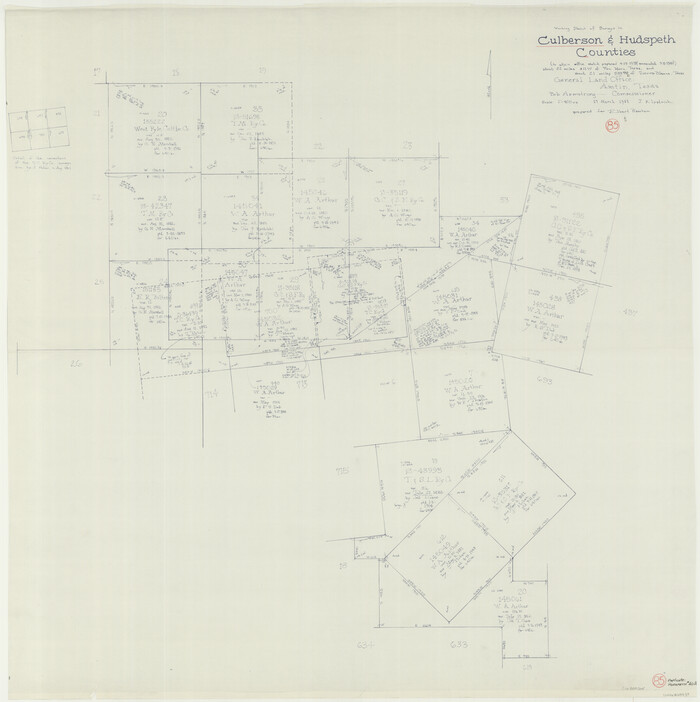
Culberson County Working Sketch 85
Print $20.00
- Digital $50.00
Culberson County Working Sketch 85
1981
Size 37.0 x 36.9 inches
Map/Doc 68539
Wood County Sketch File 14

Print $46.00
- Digital $50.00
Wood County Sketch File 14
1907
Size 14.3 x 8.7 inches
Map/Doc 40671
East Part of Brewster Co.

Print $40.00
- Digital $50.00
East Part of Brewster Co.
1952
Size 48.7 x 29.6 inches
Map/Doc 66734
Collingsworth County

Print $20.00
- Digital $50.00
Collingsworth County
1971
Size 40.7 x 34.2 inches
Map/Doc 77243
Childress County Sketch File 17a

Print $96.00
- Digital $50.00
Childress County Sketch File 17a
Size 12.4 x 8.6 inches
Map/Doc 18316
Eastland County Working Sketch 50

Print $20.00
- Digital $50.00
Eastland County Working Sketch 50
1981
Size 38.7 x 39.6 inches
Map/Doc 68831
Blanco County Rolled Sketch 14

Print $20.00
- Digital $50.00
Blanco County Rolled Sketch 14
Size 26.0 x 19.7 inches
Map/Doc 5150
Edwards County Working Sketch 11

Print $20.00
- Digital $50.00
Edwards County Working Sketch 11
1922
Size 18.8 x 31.7 inches
Map/Doc 68887
Cooke County Rolled Sketch 1

Print $20.00
- Digital $50.00
Cooke County Rolled Sketch 1
1940
Size 26.2 x 15.8 inches
Map/Doc 5560
Jack County Sketch File 9a

Print $6.00
- Digital $50.00
Jack County Sketch File 9a
1857
Size 12.5 x 7.8 inches
Map/Doc 27522
Map of Rains County

Print $20.00
- Digital $50.00
Map of Rains County
1873
Size 12.5 x 11.6 inches
Map/Doc 4618
You may also like
Sherman County Boundary File 2a

Print $10.00
- Digital $50.00
Sherman County Boundary File 2a
Size 12.9 x 8.9 inches
Map/Doc 58768
[Blotter for Roads in Moore County]
![91530, [Blotter for Roads in Moore County], Twichell Survey Records](https://historictexasmaps.com/wmedia_w700/maps/91530-1.tif.jpg)
Print $20.00
- Digital $50.00
[Blotter for Roads in Moore County]
Size 32.5 x 32.0 inches
Map/Doc 91530
[Sketch showing Block 42, Sections 221 and 222 and Block H, Sections 7 and 9]
![91714, [Sketch showing Block 42, Sections 221 and 222 and Block H, Sections 7 and 9], Twichell Survey Records](https://historictexasmaps.com/wmedia_w700/maps/91714-1.tif.jpg)
Print $2.00
- Digital $50.00
[Sketch showing Block 42, Sections 221 and 222 and Block H, Sections 7 and 9]
1919
Size 5.6 x 5.0 inches
Map/Doc 91714
[Capitol Leagues 633- 664]
![91076, [Capitol Leagues 633- 664], Twichell Survey Records](https://historictexasmaps.com/wmedia_w700/maps/91076-1.tif.jpg)
Print $20.00
- Digital $50.00
[Capitol Leagues 633- 664]
Size 17.0 x 14.6 inches
Map/Doc 91076
Houston County Working Sketch 4

Print $20.00
- Digital $50.00
Houston County Working Sketch 4
1911
Size 15.5 x 21.8 inches
Map/Doc 66234
Right of Way and Track Map, the Missouri, Kansas and Texas Ry. of Texas operated by the Missouri, Kansas and Texas Ry. of Texas, San Antonio Division

Print $40.00
- Digital $50.00
Right of Way and Track Map, the Missouri, Kansas and Texas Ry. of Texas operated by the Missouri, Kansas and Texas Ry. of Texas, San Antonio Division
1918
Size 25.6 x 57.8 inches
Map/Doc 64582
Hudspeth County Sketch File 49

Print $18.00
- Digital $50.00
Hudspeth County Sketch File 49
1986
Size 11.2 x 8.7 inches
Map/Doc 27065
Presidio County Sketch File 57

Print $8.00
- Digital $50.00
Presidio County Sketch File 57
1938
Size 14.3 x 8.9 inches
Map/Doc 34624
McLean, Texas Section 22, Block R

Print $20.00
- Digital $50.00
McLean, Texas Section 22, Block R
Size 16.0 x 16.1 inches
Map/Doc 90721
Flight Mission No. BRE-2P, Frame 34, Nueces County

Print $20.00
- Digital $50.00
Flight Mission No. BRE-2P, Frame 34, Nueces County
1956
Size 18.7 x 22.6 inches
Map/Doc 86736
Upton County Rolled Sketch 16

Print $20.00
- Digital $50.00
Upton County Rolled Sketch 16
1927
Size 18.9 x 37.7 inches
Map/Doc 8071
Castro County Sketch File 18

Print $20.00
- Digital $50.00
Castro County Sketch File 18
1988
Size 40.4 x 37.7 inches
Map/Doc 10330