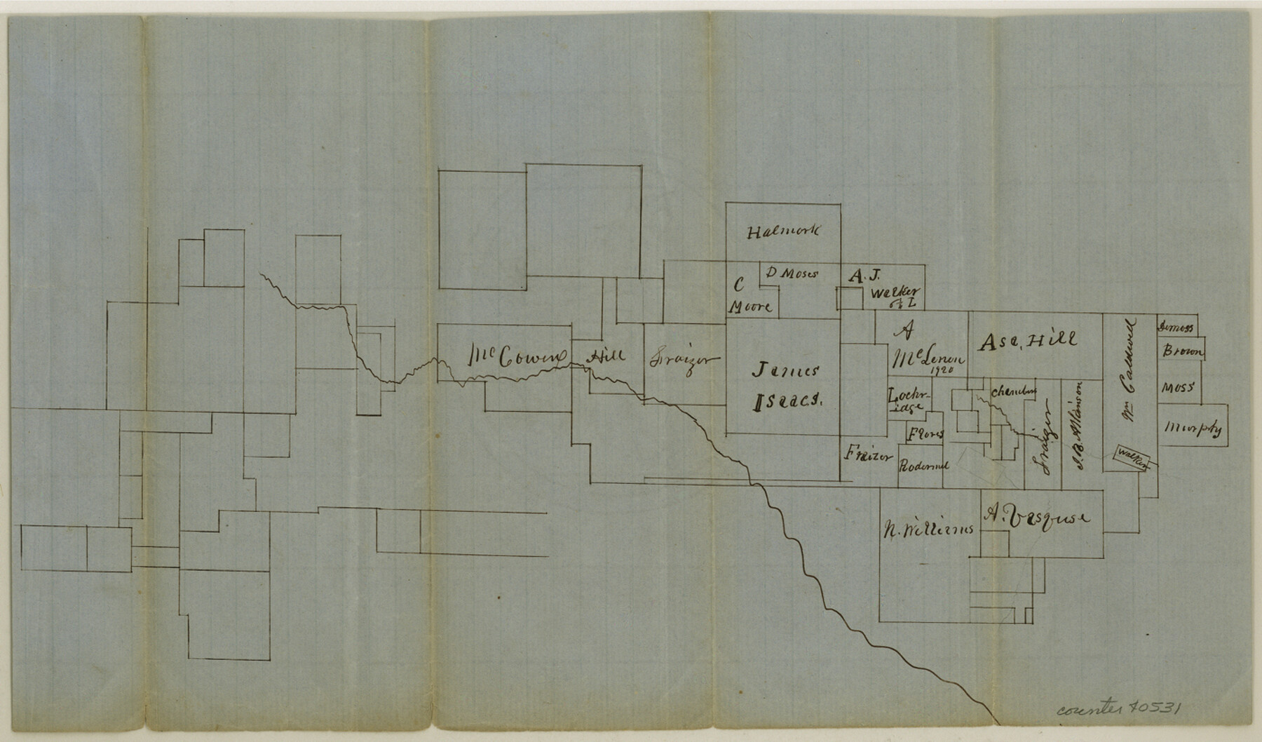
Wise County Sketch File 5
[Two sketches of surveys near the east county line, southeast of Decatur]
-
Map/Doc
40531
-
Collection
General Map Collection
-
Object Dates
8/23/1856 (Creation Date)
-
People and Organizations
R.W. Allen (Surveyor/Engineer)
-
Counties
Wise Denton
-
Subjects
Surveying Sketch File
-
Height x Width
8.2 x 14.0 inches
20.8 x 35.6 cm
-
Medium
paper, manuscript
Part of: General Map Collection
Presidio County Working Sketch 137

Print $20.00
- Digital $50.00
Presidio County Working Sketch 137
1990
Size 24.1 x 42.8 inches
Map/Doc 71815
Leon County Sketch File 36

Print $6.00
- Digital $50.00
Leon County Sketch File 36
1994
Size 14.2 x 8.7 inches
Map/Doc 29850
Brewster County Working Sketch 15

Print $20.00
- Digital $50.00
Brewster County Working Sketch 15
1929
Size 30.4 x 40.9 inches
Map/Doc 67548
Leon County Working Sketch 19

Print $20.00
- Digital $50.00
Leon County Working Sketch 19
1962
Size 31.2 x 31.4 inches
Map/Doc 70418
Montgomery County

Print $20.00
- Digital $50.00
Montgomery County
1871
Size 21.5 x 23.9 inches
Map/Doc 4598
Cameron County Rolled Sketch 27

Print $20.00
- Digital $50.00
Cameron County Rolled Sketch 27
Size 19.0 x 39.5 inches
Map/Doc 5392
Marion County Working Sketch 26

Print $20.00
- Digital $50.00
Marion County Working Sketch 26
1970
Size 32.3 x 43.1 inches
Map/Doc 70802
Edwards County Working Sketch 105
Print $40.00
- Digital $50.00
Edwards County Working Sketch 105
1972
Size 54.9 x 36.2 inches
Map/Doc 62186
Tyler County Rolled Sketch 3

Print $20.00
- Digital $50.00
Tyler County Rolled Sketch 3
1946
Size 45.5 x 35.6 inches
Map/Doc 10027
Hutchinson County Rolled Sketch 38

Print $40.00
- Digital $50.00
Hutchinson County Rolled Sketch 38
1955
Size 43.6 x 67.7 inches
Map/Doc 9248
Polk County Working Sketch Graphic Index

Print $20.00
- Digital $50.00
Polk County Working Sketch Graphic Index
1943
Size 46.9 x 41.5 inches
Map/Doc 76668
Map of Drum, Oyster & Bastrop Bays & vicinity in Brazoria County showing subdivision for mineral development

Print $20.00
- Digital $50.00
Map of Drum, Oyster & Bastrop Bays & vicinity in Brazoria County showing subdivision for mineral development
Size 36.8 x 47.3 inches
Map/Doc 65808
You may also like
Callahan County

Print $20.00
- Digital $50.00
Callahan County
1918
Size 45.3 x 41.0 inches
Map/Doc 66743
A general map of Great Britain and Ireland with part of Holland, Flanders, France & agreable to modern history

Print $20.00
A general map of Great Britain and Ireland with part of Holland, Flanders, France & agreable to modern history
1750
Size 21.6 x 25.7 inches
Map/Doc 97435
Flight Mission No. BRA-8M, Frame 25, Jefferson County

Print $20.00
- Digital $50.00
Flight Mission No. BRA-8M, Frame 25, Jefferson County
1953
Size 18.4 x 22.5 inches
Map/Doc 85580
Fort Bend County Sketch File 13

Print $30.00
- Digital $50.00
Fort Bend County Sketch File 13
1888
Size 14.3 x 8.8 inches
Map/Doc 22908
Map of the country adjacent to the left bank of the Rio Grande below Matamoros

Print $20.00
- Digital $50.00
Map of the country adjacent to the left bank of the Rio Grande below Matamoros
1847
Size 18.3 x 27.3 inches
Map/Doc 72868
[Sketch of Blocks M-19, 21W, JAD, 9 and G. & M. Block 5]
![91736, [Sketch of Blocks M-19, 21W, JAD, 9 and G. & M. Block 5], Twichell Survey Records](https://historictexasmaps.com/wmedia_w700/maps/91736-1.tif.jpg)
Print $20.00
- Digital $50.00
[Sketch of Blocks M-19, 21W, JAD, 9 and G. & M. Block 5]
Size 34.0 x 25.9 inches
Map/Doc 91736
Johnson's Military Map of the United States showing the Forts, Military Posts & all the Military Divisions with enlarged plans of southern harbors

Print $20.00
- Digital $50.00
Johnson's Military Map of the United States showing the Forts, Military Posts & all the Military Divisions with enlarged plans of southern harbors
1861
Map/Doc 93947
General Highway Map, Concho County, Texas

Print $20.00
General Highway Map, Concho County, Texas
1961
Size 24.6 x 18.3 inches
Map/Doc 79420
Colorado County Sketch File 35

Print $13.00
- Digital $50.00
Colorado County Sketch File 35
2005
Size 44.0 x 28.0 inches
Map/Doc 83564
King County Rolled Sketch 12

Print $20.00
- Digital $50.00
King County Rolled Sketch 12
1955
Size 40.9 x 45.7 inches
Map/Doc 9352
Stonewall County Rolled Sketch 27

Print $20.00
- Digital $50.00
Stonewall County Rolled Sketch 27
Size 31.0 x 44.2 inches
Map/Doc 9966
Carte Generale des Treize Etats-Unis de l'Amerique Septentrionale

Print $20.00
- Digital $50.00
Carte Generale des Treize Etats-Unis de l'Amerique Septentrionale
1783
Size 22.9 x 27.0 inches
Map/Doc 93678