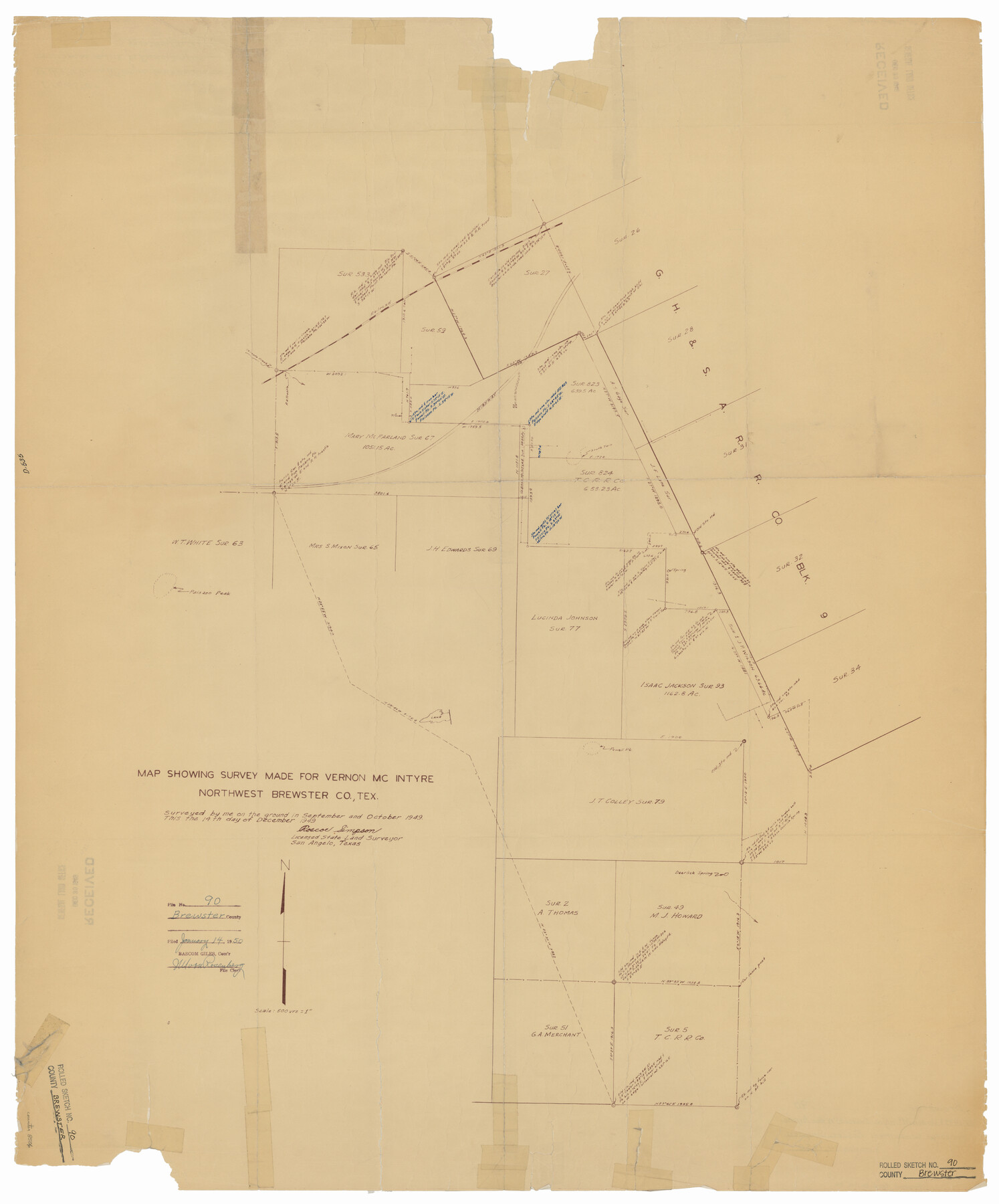
Brewster County Rolled Sketch 90
Map showing surveys made for Vernon McIntyre, northwest Brewster Co., Tex.
-
Map/Doc
8506
-
Collection
General Map Collection
-
Object Dates
1949 (Survey Date)
1950/1/14 (File Date)
1949/12/14 (Creation Date)
-
People and Organizations
Roscoe Simpson (Surveyor/Engineer)
-
Counties
Brewster
-
Subjects
Surveying Rolled Sketch
-
Height x Width
37.5 x 31.1 inches
95.3 x 79.0 cm
-
Medium
van dyke/brownline/sepia
-
Scale
1" = 500 varas
Part of: General Map Collection
Hill County Working Sketch 4

Print $20.00
- Digital $50.00
Hill County Working Sketch 4
1982
Size 25.3 x 23.3 inches
Map/Doc 66190
Randall County Rolled Sketch 8

Print $20.00
- Digital $50.00
Randall County Rolled Sketch 8
Size 32.9 x 40.6 inches
Map/Doc 7429
Dickens County Sketch File 38

Print $4.00
- Digital $50.00
Dickens County Sketch File 38
1904
Size 10.8 x 7.3 inches
Map/Doc 21048
Uvalde County Working Sketch 66

Print $20.00
- Digital $50.00
Uvalde County Working Sketch 66
1942
Size 20.9 x 21.3 inches
Map/Doc 75968
Travis County Appraisal District Plat Map 2_0805

Print $20.00
- Digital $50.00
Travis County Appraisal District Plat Map 2_0805
Size 21.4 x 26.4 inches
Map/Doc 94231
Medina County Sketch File 8

Print $4.00
- Digital $50.00
Medina County Sketch File 8
Size 9.3 x 6.6 inches
Map/Doc 31456
Jefferson County NRC Article 33.136 Location Key Sheet

Print $20.00
- Digital $50.00
Jefferson County NRC Article 33.136 Location Key Sheet
1970
Size 27.0 x 23.0 inches
Map/Doc 77028
Foard County Boundary File 2a

Print $40.00
- Digital $50.00
Foard County Boundary File 2a
Size 33.2 x 14.7 inches
Map/Doc 53514
Tom Green County

Print $20.00
- Digital $50.00
Tom Green County
1856
Size 23.3 x 27.7 inches
Map/Doc 4089
Pecos County Rolled Sketch 166

Print $22.00
- Digital $50.00
Pecos County Rolled Sketch 166
Size 32.5 x 37.6 inches
Map/Doc 9747
Flight Mission No. BRE-1P, Frame 55, Nueces County

Print $20.00
- Digital $50.00
Flight Mission No. BRE-1P, Frame 55, Nueces County
1956
Size 18.3 x 22.2 inches
Map/Doc 86644
Kendall County Sketch File 7

Print $4.00
- Digital $50.00
Kendall County Sketch File 7
1848
Size 8.2 x 10.4 inches
Map/Doc 28688
You may also like
Flight Mission No. DCL-7C, Frame 41, Kenedy County

Print $20.00
- Digital $50.00
Flight Mission No. DCL-7C, Frame 41, Kenedy County
1943
Size 15.4 x 15.2 inches
Map/Doc 86029

Terrell County Sketch File 27

Print $10.00
- Digital $50.00
Terrell County Sketch File 27
1936
Size 8.7 x 11.3 inches
Map/Doc 37971
The Republic County of Harrison. December 31, 1844

Print $20.00
The Republic County of Harrison. December 31, 1844
2020
Size 18.6 x 21.7 inches
Map/Doc 96176
Austin County Working Sketch 2

Print $20.00
- Digital $50.00
Austin County Working Sketch 2
1944
Size 23.3 x 27.0 inches
Map/Doc 67243
Val Verde County Boundary File 2

Print $4.00
- Digital $50.00
Val Verde County Boundary File 2
Size 11.4 x 8.8 inches
Map/Doc 59575
Flight Mission No. BRA-7M, Frame 37, Jefferson County

Print $20.00
- Digital $50.00
Flight Mission No. BRA-7M, Frame 37, Jefferson County
1953
Size 18.7 x 22.4 inches
Map/Doc 85488
Val Verde County Sketch File XXX9

Print $4.00
- Digital $50.00
Val Verde County Sketch File XXX9
Size 11.0 x 8.5 inches
Map/Doc 39108
Montague County Working Sketch 13

Print $20.00
- Digital $50.00
Montague County Working Sketch 13
1939
Size 26.0 x 20.6 inches
Map/Doc 71079
[Location St. L. & S. W. R. R. Through Cherokee County]
![64042, [Location St. L. & S. W. R. R. Through Cherokee County], General Map Collection](https://historictexasmaps.com/wmedia_w700/maps/64042-1.tif.jpg)
Print $40.00
- Digital $50.00
[Location St. L. & S. W. R. R. Through Cherokee County]
Size 92.0 x 39.9 inches
Map/Doc 64042
[Sketch Showing Wm. T. Brewer, John R. Taylor, Wm. F. Butler, Timothy DeVore, L. M. Thorn and adjoining surveys]
![89745, [Sketch Showing Wm. T. Brewer, John R. Taylor, Wm. F. Butler, Timothy DeVore, L. M. Thorn and adjoining surveys], Twichell Survey Records](https://historictexasmaps.com/wmedia_w700/maps/89745-1.tif.jpg)
Print $40.00
- Digital $50.00
[Sketch Showing Wm. T. Brewer, John R. Taylor, Wm. F. Butler, Timothy DeVore, L. M. Thorn and adjoining surveys]
Size 37.1 x 56.1 inches
Map/Doc 89745
[Madison County School Land, W. Perry and other surveys to the East]
![90428, [Madison County School Land, W. Perry and other surveys to the East], Twichell Survey Records](https://historictexasmaps.com/wmedia_w700/maps/90428-1.tif.jpg)
Print $20.00
- Digital $50.00
[Madison County School Land, W. Perry and other surveys to the East]
Size 12.9 x 18.0 inches
Map/Doc 90428