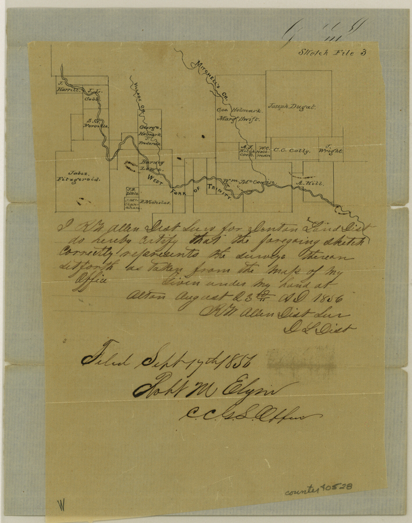
Wise County Sketch File 3
[Sketch of surveys near the West Fork of the Trinity River west of Decatur]
-
Map/Doc
40528
-
Collection
General Map Collection
-
Object Dates
8/23/1856 (Creation Date)
9/17/1856 (File Date)
-
People and Organizations
R.W. Allen (Surveyor/Engineer)
-
Counties
Wise
-
Subjects
Surveying Sketch File
-
Height x Width
10.2 x 8.0 inches
25.9 x 20.3 cm
-
Medium
paper, manuscript
-
Features
Mitchell's Creek
Village Creek
West Fork of Trinity River
Part of: General Map Collection
Houston County Sketch File 14

Print $6.00
- Digital $50.00
Houston County Sketch File 14
1886
Size 8.8 x 13.0 inches
Map/Doc 26778
Cottle County Working Sketch 16

Print $20.00
- Digital $50.00
Cottle County Working Sketch 16
1975
Size 24.5 x 21.6 inches
Map/Doc 68326
Llano County Boundary File 1a

Print $44.00
- Digital $50.00
Llano County Boundary File 1a
Size 13.2 x 8.1 inches
Map/Doc 56430
Atascosa County Working Sketch Graphic Index

Print $20.00
- Digital $50.00
Atascosa County Working Sketch Graphic Index
1948
Size 46.1 x 42.8 inches
Map/Doc 76458
South Part Pecos County

Print $20.00
- Digital $50.00
South Part Pecos County
1976
Size 35.0 x 42.9 inches
Map/Doc 77393
Jim Hogg County Rolled Sketch EJF

Print $20.00
- Digital $50.00
Jim Hogg County Rolled Sketch EJF
1937
Size 36.0 x 32.4 inches
Map/Doc 9320
Lee County Sketch File 8

Print $6.00
- Digital $50.00
Lee County Sketch File 8
1838
Size 12.8 x 8.3 inches
Map/Doc 29706
Potter County Boundary File 4b

Print $20.00
- Digital $50.00
Potter County Boundary File 4b
Size 9.2 x 32.9 inches
Map/Doc 58012
Reeves County Working Sketch 44

Print $20.00
- Digital $50.00
Reeves County Working Sketch 44
1974
Size 46.9 x 32.1 inches
Map/Doc 63487
Newton County Aerial Photograph Index Sheet 6

Print $20.00
- Digital $50.00
Newton County Aerial Photograph Index Sheet 6
1953
Size 24.0 x 18.4 inches
Map/Doc 83735
Dimmit County Working Sketch 12

Print $20.00
- Digital $50.00
Dimmit County Working Sketch 12
1941
Size 14.4 x 16.3 inches
Map/Doc 68673
Cherokee County Sketch File 34

Print $12.00
- Digital $50.00
Cherokee County Sketch File 34
1954
Size 11.2 x 8.9 inches
Map/Doc 18198
You may also like
Panola County

Print $20.00
- Digital $50.00
Panola County
1947
Size 40.7 x 40.3 inches
Map/Doc 73257
Map of Padre Island Showing Location of Zoning Districts

Print $20.00
- Digital $50.00
Map of Padre Island Showing Location of Zoning Districts
1971
Size 26.4 x 18.8 inches
Map/Doc 4813
Subdivision Map of Childress County School Land situated in Bailey and Cochran Counties, Tex.

Print $20.00
- Digital $50.00
Subdivision Map of Childress County School Land situated in Bailey and Cochran Counties, Tex.
Size 22.8 x 26.2 inches
Map/Doc 90200
La Salle County Rolled Sketch 14B

Print $20.00
- Digital $50.00
La Salle County Rolled Sketch 14B
Size 20.7 x 23.0 inches
Map/Doc 6578
[T. & P. Blocks 43-45, Townships 1S and 1N]
![90878, [T. & P. Blocks 43-45, Townships 1S and 1N], Twichell Survey Records](https://historictexasmaps.com/wmedia_w700/maps/90878-2.tif.jpg)
Print $20.00
- Digital $50.00
[T. & P. Blocks 43-45, Townships 1S and 1N]
Size 22.9 x 18.0 inches
Map/Doc 90878
General Highway Map, Winkler County, Texas

Print $20.00
General Highway Map, Winkler County, Texas
1961
Size 18.2 x 24.8 inches
Map/Doc 79717
Flight Mission No. BQR-16K, Frame 36, Brazoria County

Print $20.00
- Digital $50.00
Flight Mission No. BQR-16K, Frame 36, Brazoria County
1952
Size 18.4 x 22.2 inches
Map/Doc 84103
Culberson County Rolled Sketch 54

Print $40.00
- Digital $50.00
Culberson County Rolled Sketch 54
1968
Size 59.0 x 29.4 inches
Map/Doc 10300
Val Verde County Working Sketch 11

Print $20.00
- Digital $50.00
Val Verde County Working Sketch 11
1919
Size 32.0 x 26.5 inches
Map/Doc 72146
Frio County Working Sketch 27

Print $20.00
- Digital $50.00
Frio County Working Sketch 27
Size 25.3 x 36.8 inches
Map/Doc 78193
Matagorda County Rolled Sketch 28

Print $20.00
- Digital $50.00
Matagorda County Rolled Sketch 28
1945
Size 33.3 x 43.4 inches
Map/Doc 9481
Location Survey of the Southern Kansas Railway, Kiowa Extension from a point in Drake's Location, in Indian Territory 100 miles from south line of Kansas, continuing up Wolf Creek and South Canadian River to Cottonwood Creek in Hutchinson County

Print $20.00
- Digital $50.00
Location Survey of the Southern Kansas Railway, Kiowa Extension from a point in Drake's Location, in Indian Territory 100 miles from south line of Kansas, continuing up Wolf Creek and South Canadian River to Cottonwood Creek in Hutchinson County
1886
Size 38.9 x 36.0 inches
Map/Doc 88838