Cherokee County Sketch File 34
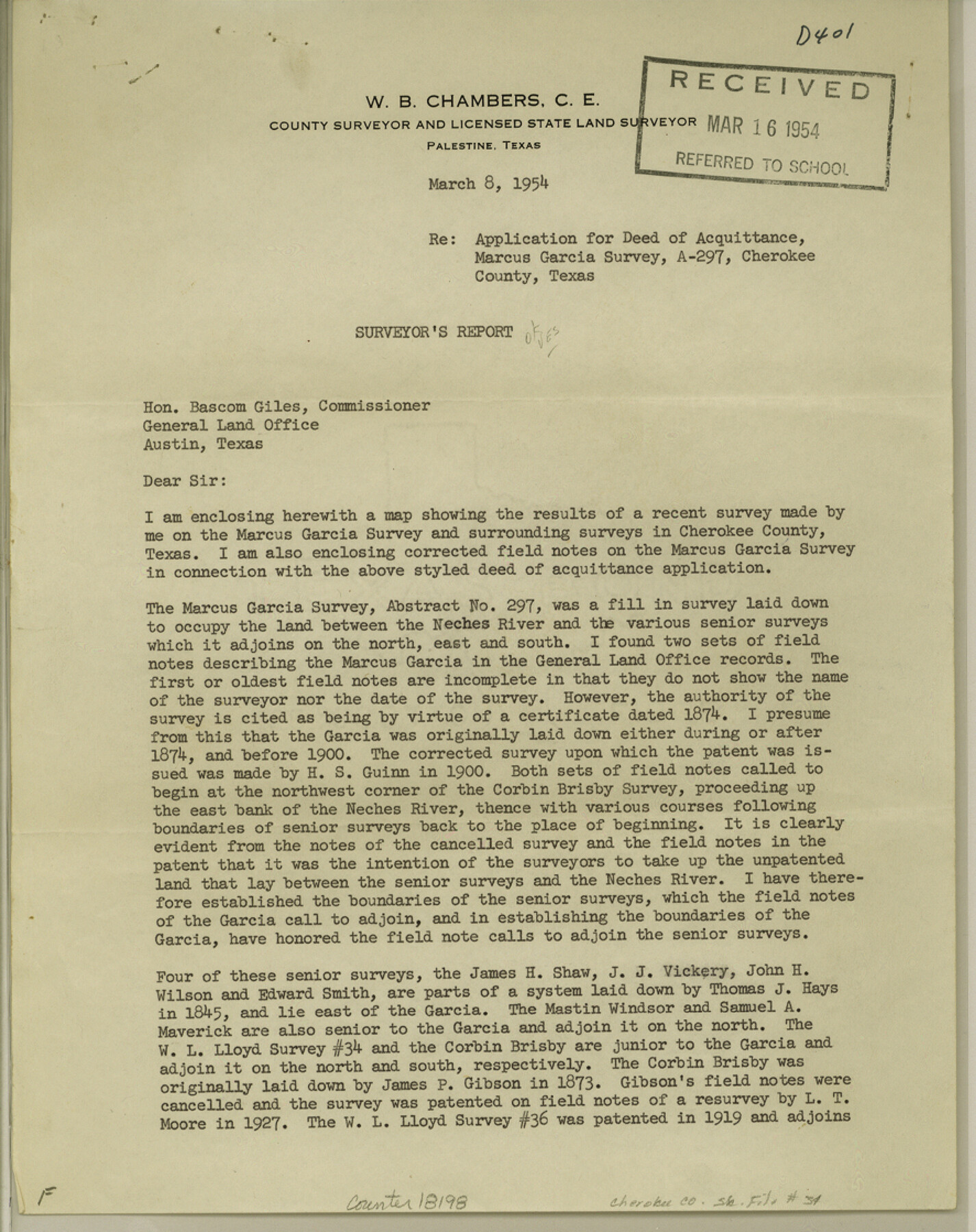
[Surveyor's report regarding application for Deed of Acquittance, Marcus Garcia survey, A-297]
-
Map/Doc
18198
-
Collection
General Map Collection
-
Object Dates
1954/3/8 (Creation Date)
1954/3/16 (File Date)
-
People and Organizations
W.B. Chambers (Surveyor/Engineer)
-
Counties
Cherokee
-
Subjects
Surveying Sketch File
-
Height x Width
11.2 x 8.9 inches
28.4 x 22.6 cm
-
Medium
paper, print
-
Features
Neches River
Part of: General Map Collection
Bell County Sketch File 19a

Print $4.00
- Digital $50.00
Bell County Sketch File 19a
Size 8.1 x 8.7 inches
Map/Doc 14404
Nueces County Rolled Sketch 72

Print $20.00
- Digital $50.00
Nueces County Rolled Sketch 72
1980
Size 18.1 x 25.8 inches
Map/Doc 6930
Bell County Working Sketch 11

Print $20.00
- Digital $50.00
Bell County Working Sketch 11
1956
Size 31.8 x 24.4 inches
Map/Doc 67351
Brewster County Sketch File NS-4e

Print $26.00
- Digital $50.00
Brewster County Sketch File NS-4e
1930
Size 8.7 x 11.2 inches
Map/Doc 15965
Fractional Township No. 8 South Range No. 15 East of the Indian Meridian, Indian Territory

Print $20.00
- Digital $50.00
Fractional Township No. 8 South Range No. 15 East of the Indian Meridian, Indian Territory
1896
Size 19.1 x 24.3 inches
Map/Doc 75227
Lee County Working Sketch 1

Print $20.00
- Digital $50.00
Lee County Working Sketch 1
1940
Size 26.7 x 26.8 inches
Map/Doc 70380
Hardeman County Sketch File 1

Print $20.00
- Digital $50.00
Hardeman County Sketch File 1
Size 31.0 x 45.7 inches
Map/Doc 10477
Nolan County Sketch File 3

Print $20.00
- Digital $50.00
Nolan County Sketch File 3
Size 8.0 x 36.6 inches
Map/Doc 42161
Flight Mission No. CRC-3R, Frame 166, Chambers County

Print $20.00
- Digital $50.00
Flight Mission No. CRC-3R, Frame 166, Chambers County
1956
Size 18.8 x 22.4 inches
Map/Doc 84848
Topographical Map of the Rio Grande, Sheet No. 19

Print $20.00
- Digital $50.00
Topographical Map of the Rio Grande, Sheet No. 19
1912
Map/Doc 89543
Terrell County Working Sketch 54

Print $20.00
- Digital $50.00
Terrell County Working Sketch 54
1959
Size 25.2 x 42.9 inches
Map/Doc 62147
Jefferson County Rolled Sketch 57

Print $20.00
- Digital $50.00
Jefferson County Rolled Sketch 57
1874
Size 25.9 x 18.6 inches
Map/Doc 6408
You may also like
Copy of a portion of Arista's map

Print $20.00
- Digital $50.00
Copy of a portion of Arista's map
1847
Size 27.5 x 18.3 inches
Map/Doc 73058
Hutchinson County Working Sketch Graphic Index - sheet 1

Print $20.00
- Digital $50.00
Hutchinson County Working Sketch Graphic Index - sheet 1
1922
Size 44.1 x 36.8 inches
Map/Doc 76586
[Sketch showing PSL Block AX and C. C. S. D. & R. G. N. G. RR. Co. Block G]
![90838, [Sketch showing PSL Block AX and C. C. S. D. & R. G. N. G. RR. Co. Block G], Twichell Survey Records](https://historictexasmaps.com/wmedia_w700/maps/90838-2.tif.jpg)
Print $20.00
- Digital $50.00
[Sketch showing PSL Block AX and C. C. S. D. & R. G. N. G. RR. Co. Block G]
Size 25.8 x 16.6 inches
Map/Doc 90838
Plat of Re-survey Section 8, Block 66 1/2, Public School Land

Print $2.00
- Digital $50.00
Plat of Re-survey Section 8, Block 66 1/2, Public School Land
1972
Size 11.3 x 8.7 inches
Map/Doc 60299
Bastrop County Rolled Sketch 4

Print $40.00
- Digital $50.00
Bastrop County Rolled Sketch 4
1999
Size 130.2 x 30.8 inches
Map/Doc 8443
Red River County Working Sketch 37

Print $20.00
- Digital $50.00
Red River County Working Sketch 37
1964
Size 31.1 x 34.8 inches
Map/Doc 72020
San Augustine County Working Sketch 10

Print $20.00
- Digital $50.00
San Augustine County Working Sketch 10
1935
Size 35.0 x 32.2 inches
Map/Doc 63697
From Citizens of Montgomery County for the Creation of a New County to be Called Bowie, January 18, 1838

Print $20.00
From Citizens of Montgomery County for the Creation of a New County to be Called Bowie, January 18, 1838
2020
Size 19.1 x 21.7 inches
Map/Doc 96376
Uvalde County Sketch File 9

Print $4.00
- Digital $50.00
Uvalde County Sketch File 9
Size 6.8 x 8.8 inches
Map/Doc 38967
Brewster County Working Sketch 89

Print $20.00
- Digital $50.00
Brewster County Working Sketch 89
1974
Size 20.5 x 44.1 inches
Map/Doc 67689
Pecos County Working Sketch 5

Print $20.00
- Digital $50.00
Pecos County Working Sketch 5
1886
Size 22.8 x 19.2 inches
Map/Doc 71475
Kent County Boundary File 1

Print $54.00
- Digital $50.00
Kent County Boundary File 1
Size 14.2 x 8.5 inches
Map/Doc 55795