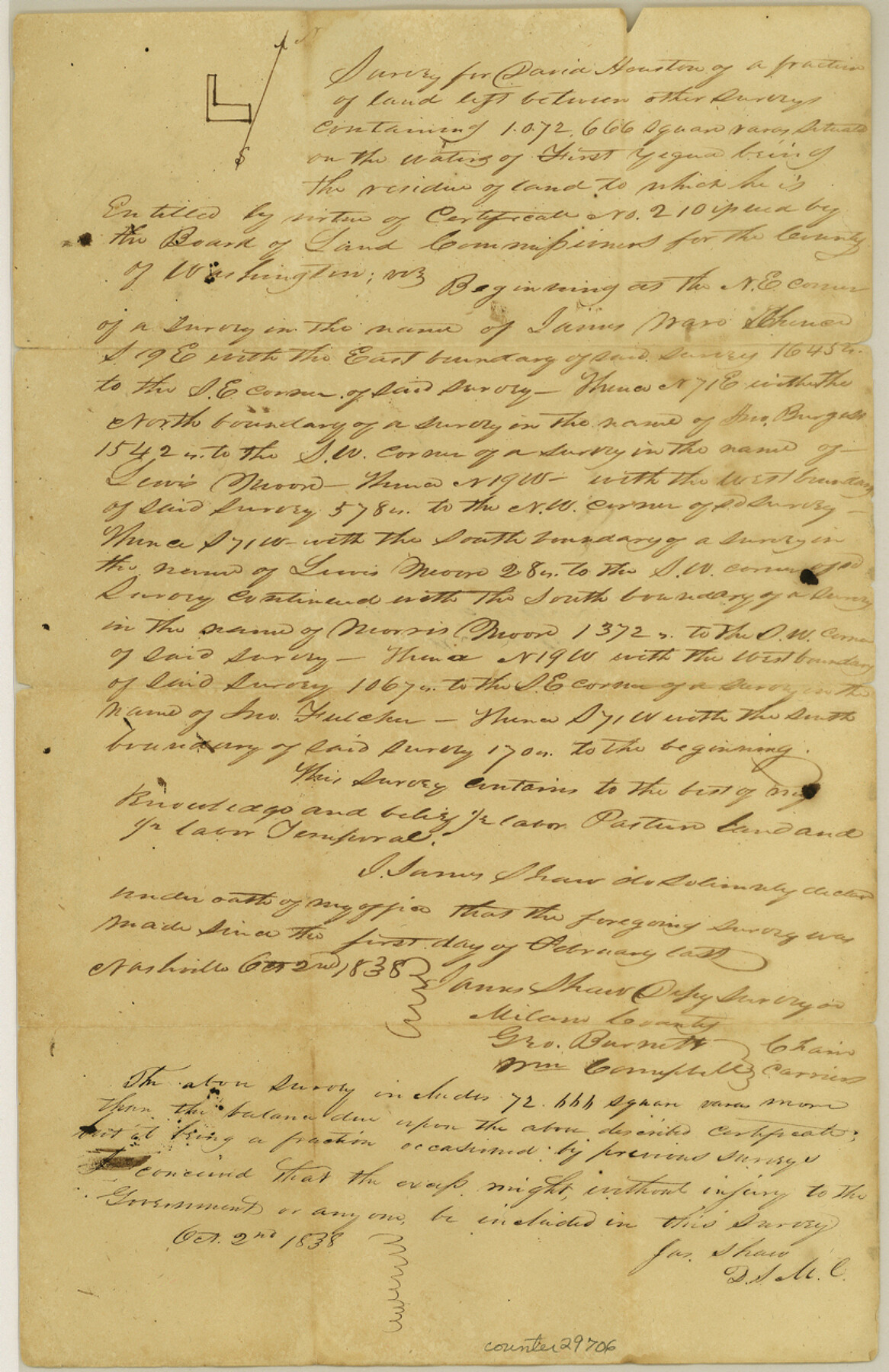
Lee County Sketch File 8
[Rejected survey on the waters of the First Yegua]
-
Map/Doc
29706
-
Collection
General Map Collection
-
Object Dates
10/2/1838 (Creation Date)
11/29/1984 (File Date)
-
People and Organizations
James Shaw (Surveyor/Engineer)
-
Counties
Lee
-
Subjects
Surveying Sketch File
-
Height x Width
12.8 x 8.3 inches
32.5 x 21.1 cm
-
Medium
paper, manuscript
Part of: General Map Collection
[Surveys along the Trinity River]
![298, [Surveys along the Trinity River], General Map Collection](https://historictexasmaps.com/wmedia_w700/maps/298.tif.jpg)
Print $2.00
- Digital $50.00
[Surveys along the Trinity River]
Size 6.3 x 9.2 inches
Map/Doc 298
Sutton County Sketch File A

Print $5.00
- Digital $50.00
Sutton County Sketch File A
Size 9.1 x 11.9 inches
Map/Doc 37389
Flight Mission No. CGI-3N, Frame 127, Cameron County

Print $20.00
- Digital $50.00
Flight Mission No. CGI-3N, Frame 127, Cameron County
1954
Size 18.8 x 22.4 inches
Map/Doc 84600
Polk County Rolled Sketch 34

Print $20.00
- Digital $50.00
Polk County Rolled Sketch 34
2023
Size 23.9 x 36.2 inches
Map/Doc 97193
Brewster County Sketch File 54

Print $4.00
- Digital $50.00
Brewster County Sketch File 54
1963
Size 11.0 x 8.5 inches
Map/Doc 16383
Reagan County Rolled Sketch 20

Print $20.00
- Digital $50.00
Reagan County Rolled Sketch 20
1948
Size 45.8 x 45.0 inches
Map/Doc 9814
Flight Mission No. BQY-4M, Frame 115, Harris County

Print $20.00
- Digital $50.00
Flight Mission No. BQY-4M, Frame 115, Harris County
1953
Size 18.6 x 22.5 inches
Map/Doc 85282
McMullen County Rolled Sketch 3

Print $20.00
- Digital $50.00
McMullen County Rolled Sketch 3
1937
Size 16.2 x 37.2 inches
Map/Doc 6722
Uvalde County Rolled Sketch 6

Print $20.00
- Digital $50.00
Uvalde County Rolled Sketch 6
Size 18.6 x 24.2 inches
Map/Doc 8091
Aransas County Sketch File 38

Print $244.00
- Digital $50.00
Aransas County Sketch File 38
1996
Size 11.1 x 8.7 inches
Map/Doc 13465
Map of Texas and Pacific Ry. Company's Surveys in the 80 Mile Reserve

Print $40.00
- Digital $50.00
Map of Texas and Pacific Ry. Company's Surveys in the 80 Mile Reserve
1885
Size 44.0 x 51.6 inches
Map/Doc 83557
Starr County Rolled Sketch 45

Print $40.00
- Digital $50.00
Starr County Rolled Sketch 45
Size 17.7 x 57.5 inches
Map/Doc 9914
You may also like
Hardeman County Sketch File 10

Print $4.00
- Digital $50.00
Hardeman County Sketch File 10
1884
Size 13.2 x 8.3 inches
Map/Doc 25006
Wavel's [Wavell's] Register of Families
![94252, Wavel's [Wavell's] Register of Families, Historical Volumes](https://historictexasmaps.com/wmedia_w700/pdf_converted_jpg/qi_pdf_thumbnail_38893.jpg)
Wavel's [Wavell's] Register of Families
Size 13.2 x 9.2 inches
Map/Doc 94252
Liberty County Rolled Sketch Q

Print $20.00
- Digital $50.00
Liberty County Rolled Sketch Q
1890
Size 31.7 x 25.1 inches
Map/Doc 6625
Jackson County Sketch File 1

Print $4.00
- Digital $50.00
Jackson County Sketch File 1
1859
Size 9.9 x 7.6 inches
Map/Doc 27617
Parker County Boundary File 3

Print $4.00
- Digital $50.00
Parker County Boundary File 3
Size 11.2 x 8.8 inches
Map/Doc 57838
[Map Showing Parmer, Castro, Bailey, Lamb, Cochran & Hockley Counties, Texas]
![1762, [Map Showing Parmer, Castro, Bailey, Lamb, Cochran & Hockley Counties, Texas], General Map Collection](https://historictexasmaps.com/wmedia_w700/maps/1762.tif.jpg)
Print $40.00
- Digital $50.00
[Map Showing Parmer, Castro, Bailey, Lamb, Cochran & Hockley Counties, Texas]
1910
Size 55.3 x 40.1 inches
Map/Doc 1762
Orange County Sketch File 44

Print $4.00
- Digital $50.00
Orange County Sketch File 44
1895
Size 10.9 x 8.8 inches
Map/Doc 33387
King County Boundary File 6

Print $16.00
- Digital $50.00
King County Boundary File 6
Size 9.2 x 6.6 inches
Map/Doc 64927
Morton, Cochran County, Texas / Morton Cemetery First Addition, Cochran County, Texas

Print $20.00
- Digital $50.00
Morton, Cochran County, Texas / Morton Cemetery First Addition, Cochran County, Texas
Size 30.8 x 34.6 inches
Map/Doc 92542
Liberty County Rolled Sketch JP1

Print $40.00
- Digital $50.00
Liberty County Rolled Sketch JP1
1935
Size 41.9 x 60.8 inches
Map/Doc 9567
Map of north end of Brazos Island

Print $20.00
- Digital $50.00
Map of north end of Brazos Island
Size 27.5 x 18.3 inches
Map/Doc 72906
Polk County Rolled Sketch 28

Print $20.00
- Digital $50.00
Polk County Rolled Sketch 28
1951
Size 45.4 x 32.0 inches
Map/Doc 9757