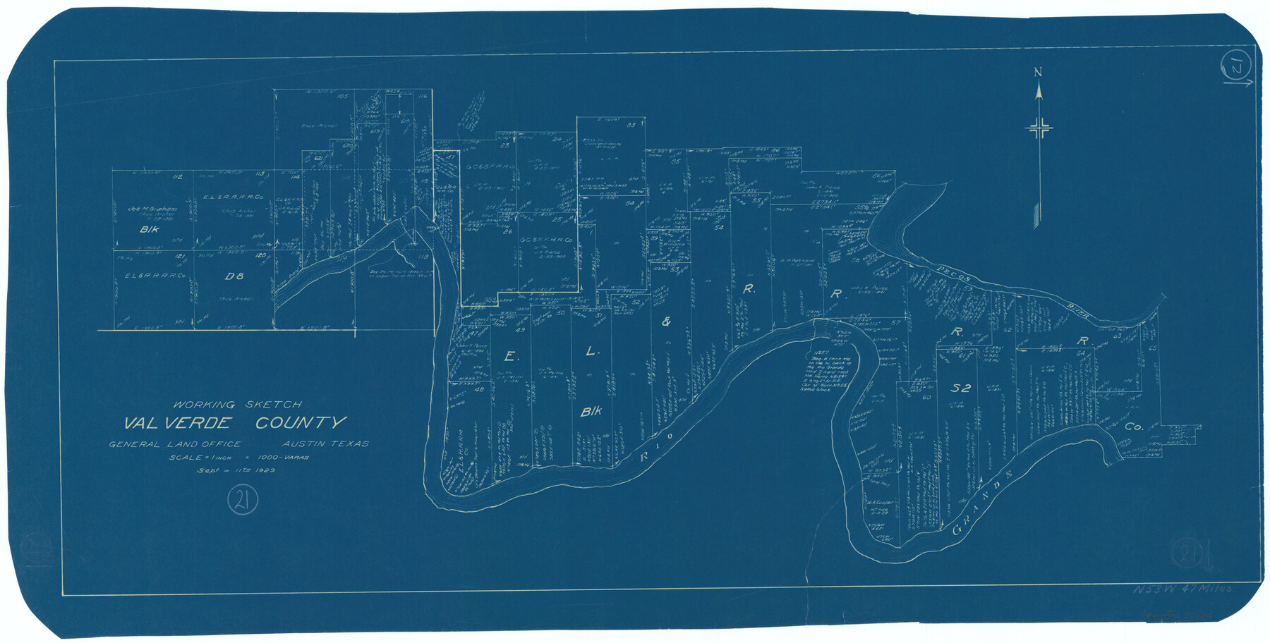
Val Verde County Working Sketch 21
-
Map/Doc
72156
-
Collection
General Map Collection
-
Object Dates
9/11/1929 (Creation Date)
-
Counties
Val Verde
-
Subjects
Surveying Working Sketch
-
Height x Width
15.2 x 30.0 inches
38.6 x 76.2 cm
-
Scale
1" = 1000 varas
Part of: General Map Collection
Hunt County Sketch File 33

Print $4.00
- Digital $50.00
Hunt County Sketch File 33
1864
Size 7.1 x 5.0 inches
Map/Doc 27141
Portion of States Submerged Area in Matagorda Bay

Print $20.00
- Digital $50.00
Portion of States Submerged Area in Matagorda Bay
1922
Size 13.9 x 15.9 inches
Map/Doc 2951
Right of Way and Track Map of The Missouri, Kansas & Texas Railway of Texas

Print $40.00
- Digital $50.00
Right of Way and Track Map of The Missouri, Kansas & Texas Railway of Texas
1918
Size 25.9 x 108.3 inches
Map/Doc 64526
Zapata County Sketch File 13

Print $4.00
- Digital $50.00
Zapata County Sketch File 13
1930
Size 11.3 x 8.8 inches
Map/Doc 40952
Stonewall County Working Sketch 15

Print $20.00
- Digital $50.00
Stonewall County Working Sketch 15
1954
Size 32.3 x 30.8 inches
Map/Doc 62322
Brazoria County NRC Article 33.136 Sketch 16

Print $72.00
- Digital $50.00
Brazoria County NRC Article 33.136 Sketch 16
2014
Size 22.0 x 36.0 inches
Map/Doc 95037
[Surveys along the Trinity River, Bois d'Arc Creek and White Rock Lake]
![256, [Surveys along the Trinity River, Bois d'Arc Creek and White Rock Lake], General Map Collection](https://historictexasmaps.com/wmedia_w700/maps/256.tif.jpg)
Print $2.00
- Digital $50.00
[Surveys along the Trinity River, Bois d'Arc Creek and White Rock Lake]
Size 10.8 x 6.7 inches
Map/Doc 256
Knox County Boundary File 6

Print $4.00
- Digital $50.00
Knox County Boundary File 6
Size 11.4 x 8.7 inches
Map/Doc 65049
Upton County Working Sketch 5

Print $20.00
- Digital $50.00
Upton County Working Sketch 5
1909
Size 15.9 x 27.1 inches
Map/Doc 69501
Reagan County

Print $20.00
- Digital $50.00
Reagan County
1903
Size 45.6 x 36.2 inches
Map/Doc 16794
[Surveys in Austin's Colony along the San Antonio Road and the Brazos and Yegua Rivers]
![203, [Surveys in Austin's Colony along the San Antonio Road and the Brazos and Yegua Rivers], General Map Collection](https://historictexasmaps.com/wmedia_w700/maps/203.tif.jpg)
Print $20.00
- Digital $50.00
[Surveys in Austin's Colony along the San Antonio Road and the Brazos and Yegua Rivers]
1831
Size 30.8 x 19.1 inches
Map/Doc 203
Culberson County Working Sketch 39

Print $40.00
- Digital $50.00
Culberson County Working Sketch 39
1966
Size 37.9 x 82.7 inches
Map/Doc 68492
You may also like
Jasper County Sketch File 1a

Print $8.00
- Digital $50.00
Jasper County Sketch File 1a
1859
Size 12.1 x 7.7 inches
Map/Doc 27765
Crockett County Working Sketch 10

Print $20.00
- Digital $50.00
Crockett County Working Sketch 10
1913
Size 23.5 x 21.6 inches
Map/Doc 68343
Newton County Rolled Sketch 26

Print $397.00
- Digital $50.00
Newton County Rolled Sketch 26
1960
Size 10.9 x 15.4 inches
Map/Doc 47265
Haskell County Boundary File 2

Print $2.00
- Digital $50.00
Haskell County Boundary File 2
Size 10.7 x 8.3 inches
Map/Doc 54538
[Sketch for Mineral Application 26501 - Sabine River, T. A. Oldhausen]
![2834, [Sketch for Mineral Application 26501 - Sabine River, T. A. Oldhausen], General Map Collection](https://historictexasmaps.com/wmedia_w700/maps/2834.tif.jpg)
Print $20.00
- Digital $50.00
[Sketch for Mineral Application 26501 - Sabine River, T. A. Oldhausen]
1931
Size 23.9 x 36.0 inches
Map/Doc 2834
Pecos County Working Sketch 44

Print $20.00
- Digital $50.00
Pecos County Working Sketch 44
1945
Size 29.6 x 35.0 inches
Map/Doc 71516
Young County Working Sketch 15

Print $20.00
- Digital $50.00
Young County Working Sketch 15
1952
Size 13.7 x 18.0 inches
Map/Doc 62038
Map of the Town of Harrold, Wilbarger County, Texas on the line of the Fort Worth and Denver City Railway

Print $20.00
- Digital $50.00
Map of the Town of Harrold, Wilbarger County, Texas on the line of the Fort Worth and Denver City Railway
1887
Size 31.2 x 28.6 inches
Map/Doc 2186
Tyler County Sketch File 28

Print $46.00
- Digital $50.00
Tyler County Sketch File 28
1960
Size 9.8 x 8.6 inches
Map/Doc 38699
Southern Part of Laguna Madre

Print $20.00
- Digital $50.00
Southern Part of Laguna Madre
1981
Size 45.1 x 35.8 inches
Map/Doc 73546
Hunt County Rolled Sketch 5

Print $20.00
- Digital $50.00
Hunt County Rolled Sketch 5
1956
Size 28.6 x 24.3 inches
Map/Doc 6268
Coast Chart No. 210 Aransas Pass and Corpus Christi Bay with the coast to latitude 27° 12' Texas

Print $20.00
- Digital $50.00
Coast Chart No. 210 Aransas Pass and Corpus Christi Bay with the coast to latitude 27° 12' Texas
1887
Size 27.5 x 18.3 inches
Map/Doc 72787