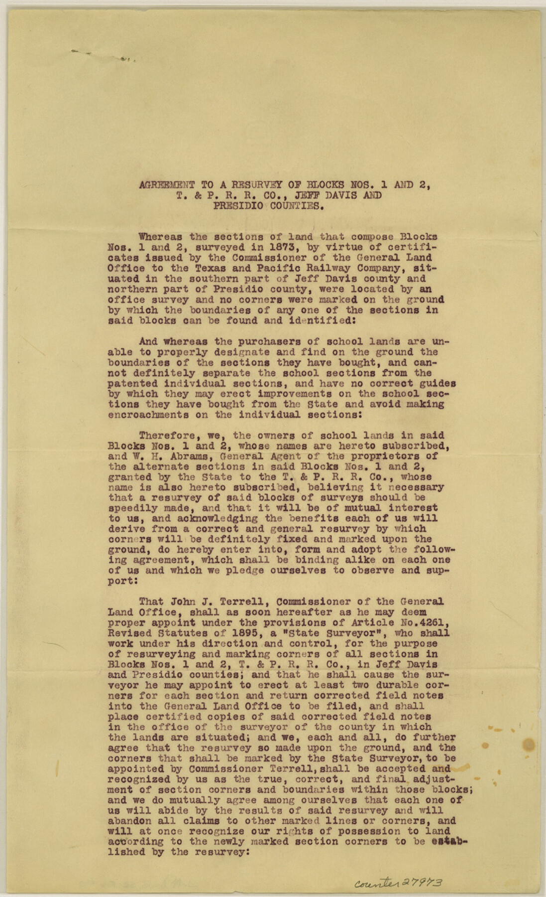
Jeff Davis County Sketch File 19
[Agreement to a resurvey of Blocks 1 and 2, T. & P. RR. Co.]
-
Map/Doc
27973
-
Collection
General Map Collection
-
Object Dates
1908 (Creation Date)
1873 (Survey Date)
-
People and Organizations
John J. Terrell (GLO Commissioner)
-
Counties
Jeff Davis Presidio
-
Subjects
Surveying Sketch File
-
Height x Width
14.4 x 8.8 inches
36.6 x 22.4 cm
-
Medium
paper, print
Part of: General Map Collection
Houston County Sketch File 24

Print $4.00
- Digital $50.00
Houston County Sketch File 24
1867
Size 14.2 x 8.2 inches
Map/Doc 26796
Map of Young County East of the Main Brazos River formerly Fannin and West of it Milam Land District

Print $20.00
- Digital $50.00
Map of Young County East of the Main Brazos River formerly Fannin and West of it Milam Land District
1859
Size 23.3 x 20.2 inches
Map/Doc 4173
Gaines County Working Sketch 34

Print $20.00
- Digital $50.00
Gaines County Working Sketch 34
1990
Size 21.0 x 20.2 inches
Map/Doc 69334
Gregg County Sketch File 4a

Print $4.00
- Digital $50.00
Gregg County Sketch File 4a
1848
Size 12.7 x 8.1 inches
Map/Doc 24572
Lampasas County Sketch File 10

Print $8.00
- Digital $50.00
Lampasas County Sketch File 10
1872
Size 12.7 x 7.9 inches
Map/Doc 29416
Township No. 2 South Range No. 24 West of the Indian Meridian

Print $20.00
- Digital $50.00
Township No. 2 South Range No. 24 West of the Indian Meridian
1875
Size 19.3 x 24.4 inches
Map/Doc 75174
Winkler County Rolled Sketch 5

Print $40.00
- Digital $50.00
Winkler County Rolled Sketch 5
1927
Size 58.0 x 38.4 inches
Map/Doc 10148
Montague County Working Sketch 41

Print $40.00
- Digital $50.00
Montague County Working Sketch 41
1923
Size 43.0 x 66.1 inches
Map/Doc 65349
Hutchinson County Rolled Sketch 44-1

Print $20.00
- Digital $50.00
Hutchinson County Rolled Sketch 44-1
2002
Size 24.0 x 36.0 inches
Map/Doc 77537
Sterling County Rolled Sketch 32

Print $20.00
- Digital $50.00
Sterling County Rolled Sketch 32
Size 17.9 x 29.4 inches
Map/Doc 7856
Terrell County Working Sketch 59

Print $20.00
- Digital $50.00
Terrell County Working Sketch 59
1961
Size 20.3 x 21.8 inches
Map/Doc 69580
Kent County Working Sketch 3b

Print $20.00
- Digital $50.00
Kent County Working Sketch 3b
1948
Size 24.9 x 23.3 inches
Map/Doc 70010
You may also like
San Patricio County Rolled Sketch 27B

Print $40.00
- Digital $50.00
San Patricio County Rolled Sketch 27B
Size 50.3 x 38.4 inches
Map/Doc 9892
Schleicher County Rolled Sketch 4

Print $20.00
- Digital $50.00
Schleicher County Rolled Sketch 4
Size 17.4 x 24.5 inches
Map/Doc 7747
Floyd County Sketch File 25

Print $14.00
- Digital $50.00
Floyd County Sketch File 25
1912
Size 11.5 x 9.0 inches
Map/Doc 22782
Flight Mission No. DIX-6P, Frame 111, Aransas County

Print $20.00
- Digital $50.00
Flight Mission No. DIX-6P, Frame 111, Aransas County
1956
Size 18.9 x 22.6 inches
Map/Doc 83817
Hartley County

Print $20.00
- Digital $50.00
Hartley County
1891
Size 25.9 x 27.8 inches
Map/Doc 3639
Preliminary Chart of Galveston Bay, Texas

Print $20.00
- Digital $50.00
Preliminary Chart of Galveston Bay, Texas
1855
Size 20.9 x 17.5 inches
Map/Doc 69868

Calhoun County Rolled Sketch 10

Print $20.00
- Digital $50.00
Calhoun County Rolled Sketch 10
Size 32.9 x 29.2 inches
Map/Doc 5366
Collin County Working Sketch 5
Print $20.00
- Digital $50.00
Collin County Working Sketch 5
1992
Size 14.2 x 19.7 inches
Map/Doc 68099
Runnels County Rolled Sketch 41

Print $20.00
- Digital $50.00
Runnels County Rolled Sketch 41
Size 26.1 x 29.8 inches
Map/Doc 7529
Coke County Working Sketch 17

Print $20.00
- Digital $50.00
Coke County Working Sketch 17
1948
Size 18.2 x 19.4 inches
Map/Doc 68054
Plan of the City of Galveston, Texas

Print $20.00
- Digital $50.00
Plan of the City of Galveston, Texas
1845
Size 18.2 x 27.4 inches
Map/Doc 62969