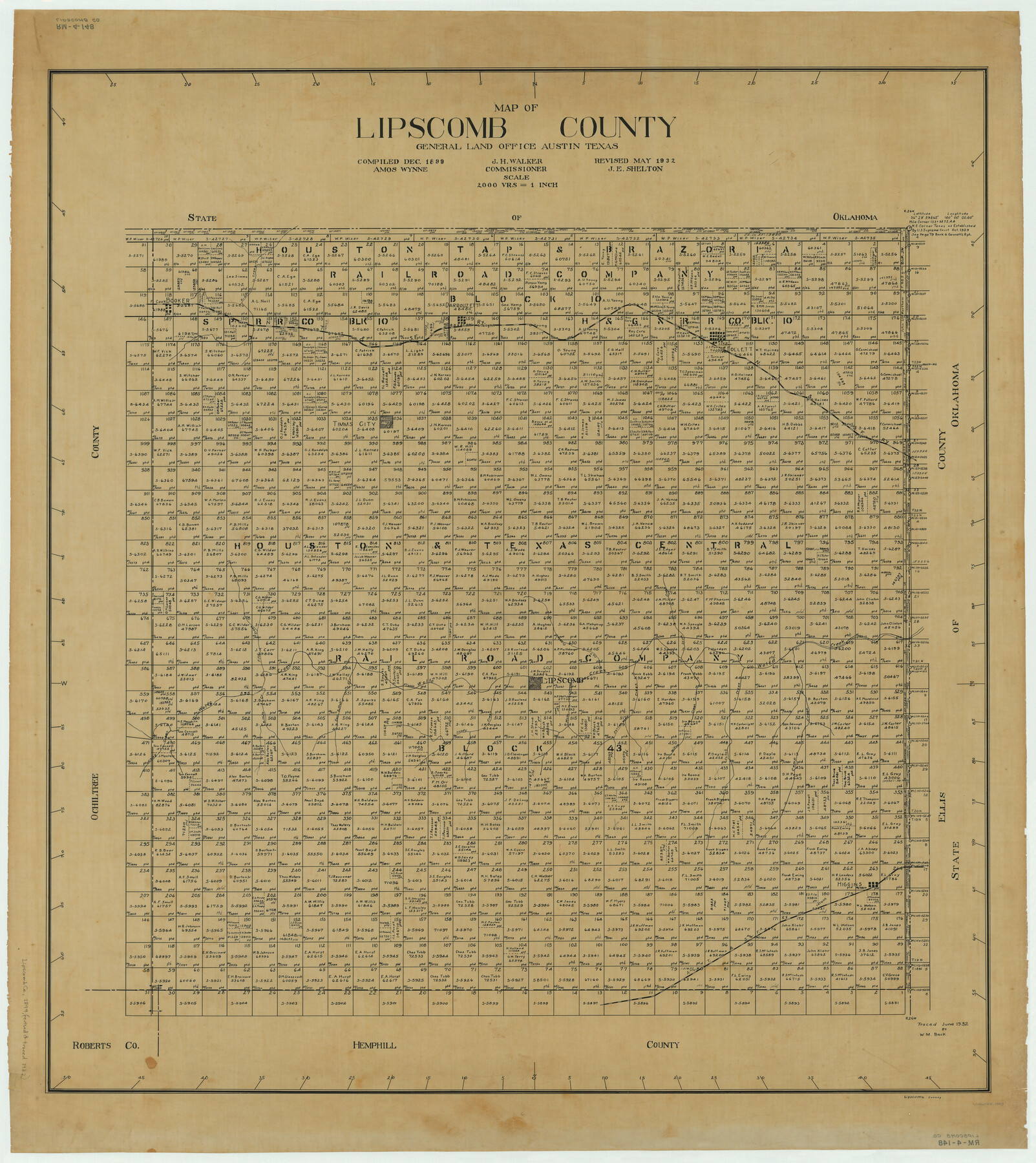
Map of Lipscomb County
RM-3-148
-
Map/Doc
1883
-
Collection
General Map Collection
-
Object Dates
12/1899 (Creation Date)
5/1932 (Revision Date)
6/1932 (Tracing Date)
-
People and Organizations
J.H. Walker (GLO Commissioner)
Amos Wynne (Compiler)
J.E. Shelton (Draftsman)
W.M. Beck (Tracer)
-
Counties
Lipscomb
-
Subjects
County
-
Height x Width
45.1 x 39.6 inches
114.6 x 100.6 cm
Part of: General Map Collection
Dickens County Sketch File D

Print $20.00
- Digital $50.00
Dickens County Sketch File D
1883
Size 15.7 x 14.8 inches
Map/Doc 11330
Old Miscellaneous File 35

Print $4.00
- Digital $50.00
Old Miscellaneous File 35
1882
Size 13.9 x 8.6 inches
Map/Doc 75757

Upton County Working Sketch 12

Print $40.00
- Digital $50.00
Upton County Working Sketch 12
1937
Size 43.6 x 77.9 inches
Map/Doc 69508
Wood County Working Sketch 3

Print $2.00
- Digital $50.00
Wood County Working Sketch 3
1916
Size 9.8 x 8.4 inches
Map/Doc 62003
La Salle County Sketch File 29a

Print $22.00
- Digital $50.00
La Salle County Sketch File 29a
1886
Size 8.9 x 12.5 inches
Map/Doc 29563
Grayson County Working Sketch Graphic Index

Print $20.00
- Digital $50.00
Grayson County Working Sketch Graphic Index
1935
Size 44.4 x 41.0 inches
Map/Doc 76558
Railroad Track Map, H&TCRRCo., Falls County, Texas

Print $4.00
- Digital $50.00
Railroad Track Map, H&TCRRCo., Falls County, Texas
1918
Size 11.8 x 18.5 inches
Map/Doc 62837
United States - Gulf Coast Texas - Southern part of Laguna Madre

Print $20.00
- Digital $50.00
United States - Gulf Coast Texas - Southern part of Laguna Madre
1941
Size 26.8 x 18.3 inches
Map/Doc 72940
Aransas County Rolled Sketch 24

Print $20.00
- Digital $50.00
Aransas County Rolled Sketch 24
Size 22.5 x 34.8 inches
Map/Doc 77495
Flight Mission No. CGI-3N, Frame 78, Cameron County

Print $20.00
- Digital $50.00
Flight Mission No. CGI-3N, Frame 78, Cameron County
1954
Size 18.6 x 22.3 inches
Map/Doc 84572
Brown County Rolled Sketch 1

Print $20.00
- Digital $50.00
Brown County Rolled Sketch 1
1969
Size 15.4 x 22.1 inches
Map/Doc 5348
You may also like
El Paso County Boundary File 15

Print $7.00
- Digital $50.00
El Paso County Boundary File 15
Size 13.7 x 8.6 inches
Map/Doc 53186
Jefferson County Sketch File 5

Print $50.00
- Digital $50.00
Jefferson County Sketch File 5
1859
Size 7.9 x 6.9 inches
Map/Doc 28103
Pecos County Sketch File 106

Print $6.00
- Digital $50.00
Pecos County Sketch File 106
1967
Size 14.2 x 8.8 inches
Map/Doc 34030
Northern Part of Laguna Madre

Print $20.00
- Digital $50.00
Northern Part of Laguna Madre
1959
Size 44.5 x 35.1 inches
Map/Doc 73525
Flight Mission No. DAG-28K, Frame 25, Matagorda County

Print $20.00
- Digital $50.00
Flight Mission No. DAG-28K, Frame 25, Matagorda County
1953
Size 18.5 x 22.3 inches
Map/Doc 86593
Map of the St. Louis, Iron Mountain and Southern Railway, and connections

Print $20.00
- Digital $50.00
Map of the St. Louis, Iron Mountain and Southern Railway, and connections
1880
Size 10.5 x 14.4 inches
Map/Doc 95786

[John H. Tyler and Bob Reid Strip Surveys in Yates Field]
![91582, [John H. Tyler and Bob Reid Strip Surveys in Yates Field], Twichell Survey Records](https://historictexasmaps.com/wmedia_w700/maps/91582-1.tif.jpg)
Print $2.00
- Digital $50.00
[John H. Tyler and Bob Reid Strip Surveys in Yates Field]
Size 14.3 x 8.8 inches
Map/Doc 91582
Highland Place an Addition to City of Lubbock - Plat of Lots and Street

Print $20.00
- Digital $50.00
Highland Place an Addition to City of Lubbock - Plat of Lots and Street
Size 26.0 x 18.1 inches
Map/Doc 92843
Flight Mission No. CGI-1N, Frame 136, Cameron County

Print $20.00
- Digital $50.00
Flight Mission No. CGI-1N, Frame 136, Cameron County
1955
Size 17.2 x 18.5 inches
Map/Doc 84492
Map of Unsurveyed Bed of Spring Creek

Print $40.00
- Digital $50.00
Map of Unsurveyed Bed of Spring Creek
1920
Size 78.7 x 27.1 inches
Map/Doc 65695
Edwards County Rolled Sketch 24

Print $20.00
- Digital $50.00
Edwards County Rolled Sketch 24
1953
Size 29.9 x 38.0 inches
Map/Doc 5810