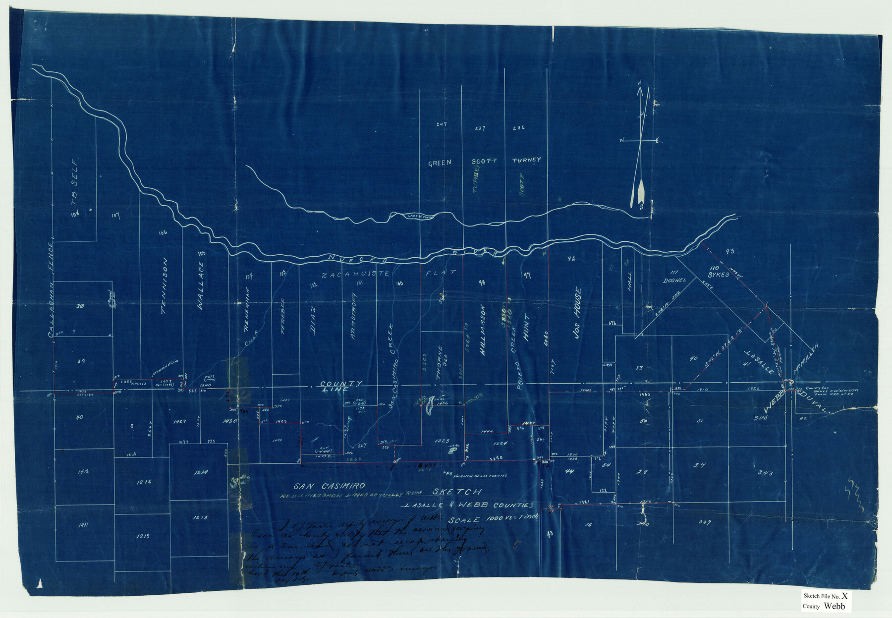
Webb County Sketch File X
[Sketch and surveyor's statement regarding surveys in the northeast corner of the county along the La Salle County line]
-
Map/Doc
39701
-
Collection
General Map Collection
-
Object Dates
7/16/1908 (Creation Date)
9/18/1908 (File Date)
-
People and Organizations
E.J. Foster (Surveyor/Engineer)
-
Counties
Webb La Salle
-
Subjects
Surveying Sketch File
-
Height x Width
11.2 x 9.0 inches
28.5 x 22.9 cm
-
Medium
blueprint/diazo
-
Features
Nueces River
Zacahuiste Flat
San Casimiro Creek
Maquallitos Hill
Part of: General Map Collection
Real County Rolled Sketch 12A

Print $20.00
- Digital $50.00
Real County Rolled Sketch 12A
Size 36.2 x 38.3 inches
Map/Doc 9837
[Sketch for Mineral Application 26501 - Sabine River, T. A. Oldhausen]
![2839, [Sketch for Mineral Application 26501 - Sabine River, T. A. Oldhausen], General Map Collection](https://historictexasmaps.com/wmedia_w700/maps/2839.tif.jpg)
Print $20.00
- Digital $50.00
[Sketch for Mineral Application 26501 - Sabine River, T. A. Oldhausen]
1931
Size 17.7 x 36.4 inches
Map/Doc 2839

Eastland County Rolled Sketch 26

Print $20.00
- Digital $50.00
Eastland County Rolled Sketch 26
1918
Size 23.2 x 17.9 inches
Map/Doc 5777
Coleman County Working Sketch 1

Print $20.00
- Digital $50.00
Coleman County Working Sketch 1
1900
Size 11.1 x 21.2 inches
Map/Doc 68067
Tracing "A" [showing Rio Grande and settlements along river]
![72887, Tracing "A" [showing Rio Grande and settlements along river], General Map Collection](https://historictexasmaps.com/wmedia_w700/maps/72887.tif.jpg)
Print $20.00
- Digital $50.00
Tracing "A" [showing Rio Grande and settlements along river]
1881
Size 18.2 x 26.5 inches
Map/Doc 72887
Nautical Chart 887-SC Intracoastal Waterway - Galveston Bay to Cedar Lakes including the Brazos and San Bernard Rivers, Texas

Print $20.00
- Digital $50.00
Nautical Chart 887-SC Intracoastal Waterway - Galveston Bay to Cedar Lakes including the Brazos and San Bernard Rivers, Texas
1971
Size 16.2 x 18.9 inches
Map/Doc 75911
Callahan County Sketch File 10b

Print $6.00
- Digital $50.00
Callahan County Sketch File 10b
Size 12.1 x 10.8 inches
Map/Doc 35883
Map No. 1 - Rio Bravo del Norte section of boundary between the United States & Mexico agreed upon by the Joint Commission under the Treaty of Guadalupe Hidalgo

Print $20.00
- Digital $50.00
Map No. 1 - Rio Bravo del Norte section of boundary between the United States & Mexico agreed upon by the Joint Commission under the Treaty of Guadalupe Hidalgo
1852
Size 18.3 x 27.0 inches
Map/Doc 72863
Wood County Rolled Sketch 6

Print $20.00
- Digital $50.00
Wood County Rolled Sketch 6
1952
Size 29.7 x 21.2 inches
Map/Doc 8284
Taylor County Sketch File A

Print $2.00
- Digital $50.00
Taylor County Sketch File A
Size 8.8 x 11.3 inches
Map/Doc 37773
Travis County Rolled Sketch 12

Print $20.00
- Digital $50.00
Travis County Rolled Sketch 12
Size 21.9 x 19.2 inches
Map/Doc 8015
You may also like
Reagan County Sketch File 5

Print $12.00
- Digital $50.00
Reagan County Sketch File 5
1927
Size 11.2 x 8.7 inches
Map/Doc 34980
[Texas Central Railway through Callahan County]
![64240, [Texas Central Railway through Callahan County], General Map Collection](https://historictexasmaps.com/wmedia_w700/maps/64240-1.tif.jpg)
Print $40.00
- Digital $50.00
[Texas Central Railway through Callahan County]
Size 24.6 x 86.3 inches
Map/Doc 64240
Matagorda County Rolled Sketch PHL1

Print $20.00
- Digital $50.00
Matagorda County Rolled Sketch PHL1
Size 36.5 x 39.1 inches
Map/Doc 9477
Sketch of Texas with the boundaries of Mexican States as shown on General Austin's map of Texas

Print $20.00
Sketch of Texas with the boundaries of Mexican States as shown on General Austin's map of Texas
1839
Size 20.9 x 16.1 inches
Map/Doc 93574
Orange County Working Sketch 8

Print $20.00
- Digital $50.00
Orange County Working Sketch 8
1922
Size 20.7 x 24.3 inches
Map/Doc 71340
Karnes County Working Sketch 10

Print $20.00
- Digital $50.00
Karnes County Working Sketch 10
1970
Size 35.5 x 26.3 inches
Map/Doc 66658
Flight Mission No. BRA-16M, Frame 174, Jefferson County

Print $20.00
- Digital $50.00
Flight Mission No. BRA-16M, Frame 174, Jefferson County
1953
Size 18.6 x 22.4 inches
Map/Doc 85772
Goliad County Sketch File 17

Print $12.00
- Digital $50.00
Goliad County Sketch File 17
1851
Size 12.4 x 8.2 inches
Map/Doc 24249
Newton County Sketch File 16

Print $5.00
- Digital $50.00
Newton County Sketch File 16
1880
Size 8.9 x 10.6 inches
Map/Doc 32390
Childress County, Texas

Print $20.00
- Digital $50.00
Childress County, Texas
1892
Size 29.3 x 22.0 inches
Map/Doc 697
Gregg County Rolled Sketch 20

Print $20.00
- Digital $50.00
Gregg County Rolled Sketch 20
1957
Size 34.6 x 44.7 inches
Map/Doc 6478
Brewster County Rolled Sketch 24B

Print $20.00
- Digital $50.00
Brewster County Rolled Sketch 24B
Size 17.2 x 22.4 inches
Map/Doc 5209