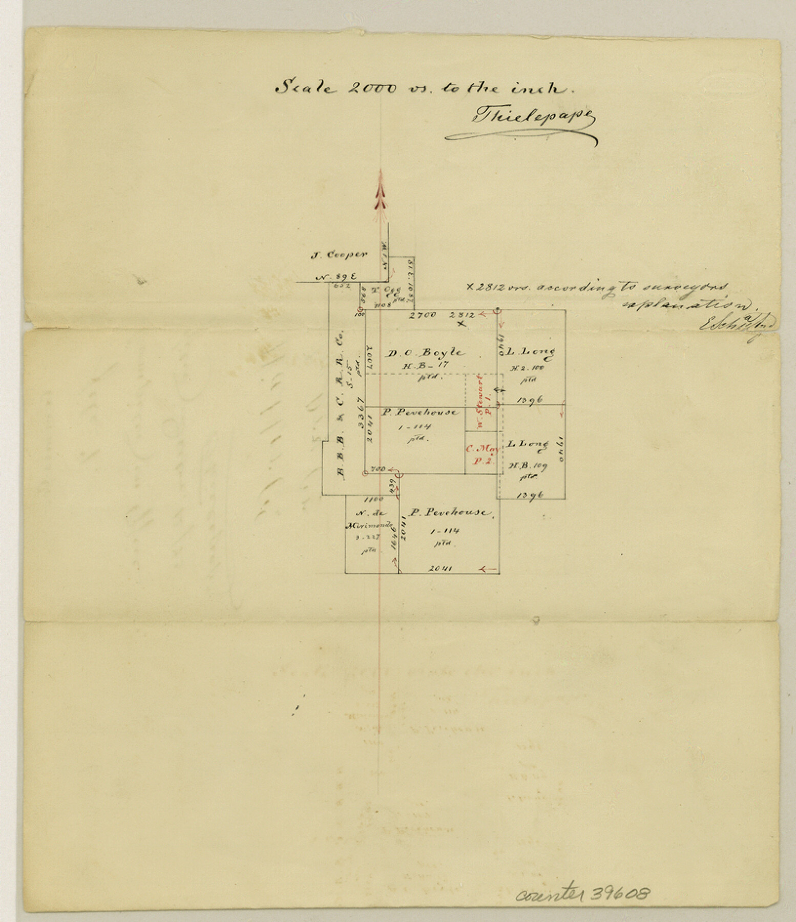
Waller County Sketch File 7
[Sketch of surveys on the boundary line between Waller County and Montgomery County in the northeast corner of Waller County near Brushy Creek]
-
Map/Doc
39608
-
Collection
General Map Collection
-
Object Dates
12/12/1873 (Creation Date)
-
People and Organizations
Thielepape (Draftsman)
-
Counties
Waller Montgomery
-
Subjects
Surveying Sketch File
-
Height x Width
9.4 x 8.2 inches
23.9 x 20.8 cm
-
Medium
paper, manuscript
-
Features
Dry Creek
Part of: General Map Collection
Hardin County Sketch File XYZ

Print $4.00
- Digital $50.00
Hardin County Sketch File XYZ
1894
Size 11.3 x 8.7 inches
Map/Doc 25073
Williamson County Working Sketch 4

Print $20.00
- Digital $50.00
Williamson County Working Sketch 4
1919
Size 23.7 x 19.4 inches
Map/Doc 72564
Crosby County Boundary File 4a

Print $30.00
- Digital $50.00
Crosby County Boundary File 4a
Size 8.8 x 32.8 inches
Map/Doc 52028
Wharton County Sketch File 23

Print $20.00
- Digital $50.00
Wharton County Sketch File 23
Size 19.3 x 19.9 inches
Map/Doc 12667
Red River County Rolled Sketch 5

Print $20.00
- Digital $50.00
Red River County Rolled Sketch 5
Size 33.5 x 32.5 inches
Map/Doc 9842
Flight Mission No. BRA-7M, Frame 186, Jefferson County

Print $20.00
- Digital $50.00
Flight Mission No. BRA-7M, Frame 186, Jefferson County
1953
Size 18.4 x 22.2 inches
Map/Doc 85554
Gonzales County Boundary File 1b

Print $52.00
- Digital $50.00
Gonzales County Boundary File 1b
Size 8.0 x 5.0 inches
Map/Doc 53803
Map showing contour of lake to be formed by the Marshall-Ford Dam on the Colorado River in Travis County, Texas and the land surveys crossed by this contour and contiguous to the lake

Print $20.00
- Digital $50.00
Map showing contour of lake to be formed by the Marshall-Ford Dam on the Colorado River in Travis County, Texas and the land surveys crossed by this contour and contiguous to the lake
1937
Size 22.6 x 18.8 inches
Map/Doc 60292
Map of Chocolate Bay, west portion of West Bay & vicinity, Brazoria & Galveston Counties showing subdivision for mineral development

Print $40.00
- Digital $50.00
Map of Chocolate Bay, west portion of West Bay & vicinity, Brazoria & Galveston Counties showing subdivision for mineral development
Size 42.0 x 58.1 inches
Map/Doc 65806
Map of Hopkins Co.

Print $20.00
- Digital $50.00
Map of Hopkins Co.
1885
Size 36.6 x 38.7 inches
Map/Doc 4982
Montgomery County Working Sketch 35

Print $20.00
- Digital $50.00
Montgomery County Working Sketch 35
1953
Size 26.6 x 21.7 inches
Map/Doc 71142
Bell County Sketch File 25a

Print $4.00
- Digital $50.00
Bell County Sketch File 25a
1880
Size 8.9 x 10.9 inches
Map/Doc 14424
You may also like
Sutton County Working Sketch 4

Print $20.00
- Digital $50.00
Sutton County Working Sketch 4
1969
Size 40.3 x 32.2 inches
Map/Doc 62347
[Northeast 1/4 County]
![90876, [Northeast 1/4 County], Twichell Survey Records](https://historictexasmaps.com/wmedia_w700/maps/90876-2.tif.jpg)
Print $20.00
- Digital $50.00
[Northeast 1/4 County]
Size 11.9 x 20.3 inches
Map/Doc 90876
Harris County Working Sketch 34

Print $40.00
- Digital $50.00
Harris County Working Sketch 34
1937
Size 37.5 x 52.1 inches
Map/Doc 65926
Upton County Rolled Sketch 41

Print $20.00
- Digital $50.00
Upton County Rolled Sketch 41
Size 27.4 x 40.8 inches
Map/Doc 8080
Pecos County Rolled Sketch 152

Print $20.00
- Digital $50.00
Pecos County Rolled Sketch 152
1960
Size 38.8 x 43.7 inches
Map/Doc 9736
[Sketch showing School Lands]
![90449, [Sketch showing School Lands], Twichell Survey Records](https://historictexasmaps.com/wmedia_w700/maps/90449-1.tif.jpg)
Print $20.00
- Digital $50.00
[Sketch showing School Lands]
Size 25.4 x 12.5 inches
Map/Doc 90449
Nueces County Sketch File 75

Print $20.00
- Digital $50.00
Nueces County Sketch File 75
1977
Size 26.1 x 27.8 inches
Map/Doc 42199
Revised Edition of Murphy and Bolanz Official Map of the City of Dallas and Suburbs

Print $20.00
Revised Edition of Murphy and Bolanz Official Map of the City of Dallas and Suburbs
1891
Size 37.9 x 30.6 inches
Map/Doc 76274
Wood County Working Sketch 2

Print $20.00
- Digital $50.00
Wood County Working Sketch 2
1913
Size 17.8 x 16.8 inches
Map/Doc 62002
Blocks 17, 18 & 19, Capitol Syndicate Subdivision of Capitol Land Reservation Leagues of Portions of Leagues Number 16, 6, 7, 8, 9, 11, 12, 13, 14, 17, 18. 19, 20, 21, 22, 38, 39, 40, 41, 42, 43, 44, 45 and 46

Print $40.00
- Digital $50.00
Blocks 17, 18 & 19, Capitol Syndicate Subdivision of Capitol Land Reservation Leagues of Portions of Leagues Number 16, 6, 7, 8, 9, 11, 12, 13, 14, 17, 18. 19, 20, 21, 22, 38, 39, 40, 41, 42, 43, 44, 45 and 46
Size 50.5 x 30.9 inches
Map/Doc 89686
Starr County Sketch File 9

Print $22.00
- Digital $50.00
Starr County Sketch File 9
Size 9.1 x 7.9 inches
Map/Doc 36861
Culberson Co.

Print $20.00
- Digital $50.00
Culberson Co.
1943
Size 41.2 x 25.5 inches
Map/Doc 77256