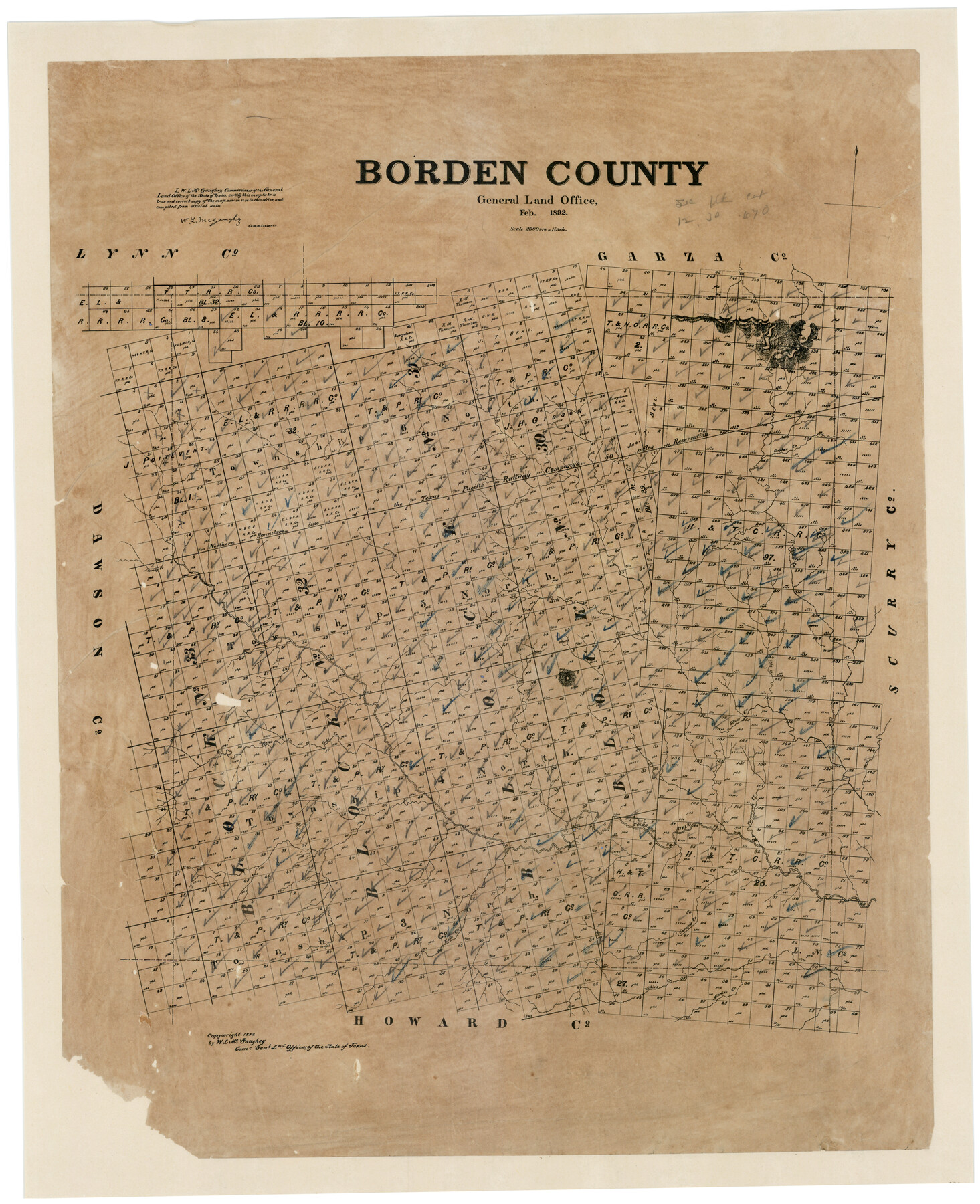
Borden County, Texas
-
Map/Doc
394
-
Collection
Maddox Collection
-
Object Dates
2/1892 (Creation Date)
-
People and Organizations
W.L. McGaughey (GLO Commissioner)
August Gast & Co. (Lithographer)
-
Counties
Borden
-
Subjects
County
-
Height x Width
25.7 x 20.9 inches
65.3 x 53.1 cm
-
Medium
paper, etching/engraving/lithograph
-
Scale
1" = 2000 varas
-
Comments
Conservation funded in 2005 by Friends of the Texas General Land Office.
-
Features
Spring Creek
Etta's Creek
Gold Creek
Silver Creek
Ned's Creek
Deer Creek
Fairmount's Creek
Colorado River
Keno Creek
Keno Creek or Gold Creek
Kate Creek
Carmen's Creek
Minnie's Creek
Willie's Creek
Part of: Maddox Collection
Coryell County, Texas

Print $20.00
- Digital $50.00
Coryell County, Texas
1879
Size 23.5 x 29.1 inches
Map/Doc 704
Baylor County, Texas

Print $20.00
- Digital $50.00
Baylor County, Texas
1879
Size 22.2 x 17.4 inches
Map/Doc 586
Sketch from the map of Bailey Co.

Print $2.00
- Digital $50.00
Sketch from the map of Bailey Co.
Size 8.4 x 7.6 inches
Map/Doc 464
Map of Lands Belonging to the Austin & Northern Land & Cattle Co., Coke Co., Texas

Print $20.00
- Digital $50.00
Map of Lands Belonging to the Austin & Northern Land & Cattle Co., Coke Co., Texas
Size 23.5 x 19.0 inches
Map/Doc 379
Map of Mason County, Texas

Print $20.00
- Digital $50.00
Map of Mason County, Texas
Size 26.0 x 19.2 inches
Map/Doc 404
Block No. 45 of the H. & T. C. R.R. Co. and Block No. 4T of the T. & N. O. R.R. Co. in Hansford and Ochiltree Cos. as resurveyed by J.L. Long, State Surveyor

Print $20.00
- Digital $50.00
Block No. 45 of the H. & T. C. R.R. Co. and Block No. 4T of the T. & N. O. R.R. Co. in Hansford and Ochiltree Cos. as resurveyed by J.L. Long, State Surveyor
1888
Size 34.1 x 28.1 inches
Map/Doc 75820
Map of South Brady Ranch, Concho County, Texas

Print $3.00
- Digital $50.00
Map of South Brady Ranch, Concho County, Texas
1880
Size 12.9 x 10.5 inches
Map/Doc 424
Map of Cherokee County, Texas

Print $20.00
- Digital $50.00
Map of Cherokee County, Texas
1879
Size 30.8 x 24.0 inches
Map/Doc 696
[Surveying Sketch of Northern Portion of Hutchinson County]
![5065, [Surveying Sketch of Northern Portion of Hutchinson County], Maddox Collection](https://historictexasmaps.com/wmedia_w700/maps/5065.tif.jpg)
Print $20.00
- Digital $50.00
[Surveying Sketch of Northern Portion of Hutchinson County]
1890
Size 26.5 x 42.5 inches
Map/Doc 5065
Sketch showing subdivision of surveys in Webb Co., Texas

Print $20.00
- Digital $50.00
Sketch showing subdivision of surveys in Webb Co., Texas
1933
Size 18.2 x 20.1 inches
Map/Doc 459
Map of Menard County

Print $20.00
- Digital $50.00
Map of Menard County
1898
Size 19.9 x 43.1 inches
Map/Doc 5042
Smithville, Bastrop County, Texas

Print $3.00
- Digital $50.00
Smithville, Bastrop County, Texas
1895
Size 11.0 x 17.2 inches
Map/Doc 531
You may also like
United States, 1956 Revised Edition

Print $20.00
- Digital $50.00
United States, 1956 Revised Edition
1946
Size 47.9 x 35.9 inches
Map/Doc 78630
Panola County Sketch File 26

Print $20.00
- Digital $50.00
Panola County Sketch File 26
1944
Size 28.5 x 27.1 inches
Map/Doc 12141
Edwards County Sketch File 15

Print $10.00
- Digital $50.00
Edwards County Sketch File 15
1893
Size 12.9 x 8.5 inches
Map/Doc 21715
Angelina County Sketch File 11f

Print $4.00
- Digital $50.00
Angelina County Sketch File 11f
1885
Size 8.2 x 12.6 inches
Map/Doc 12954

Winkler County Sketch File 15

Print $10.00
- Digital $50.00
Winkler County Sketch File 15
1944
Size 14.3 x 8.6 inches
Map/Doc 40488
English Field Notes of the Spanish Archives - Book 2

English Field Notes of the Spanish Archives - Book 2
1835
Map/Doc 96528
Presidio County Rolled Sketch 13

Print $40.00
- Digital $50.00
Presidio County Rolled Sketch 13
1882
Size 59.1 x 43.9 inches
Map/Doc 78487
Cochran County Sketch [showing lines run by C. A. Tubbs]
![90435, Cochran County Sketch [showing lines run by C. A. Tubbs], Twichell Survey Records](https://historictexasmaps.com/wmedia_w700/maps/90435-1.tif.jpg)
Print $20.00
- Digital $50.00
Cochran County Sketch [showing lines run by C. A. Tubbs]
Size 10.0 x 23.8 inches
Map/Doc 90435
Hardin County Working Sketch 23

Print $20.00
- Digital $50.00
Hardin County Working Sketch 23
1950
Size 20.7 x 29.4 inches
Map/Doc 63421
[Sketch showing the Rio Grande with towns and features annotated]
![72897, [Sketch showing the Rio Grande with towns and features annotated], General Map Collection](https://historictexasmaps.com/wmedia_w700/maps/72897.tif.jpg)
Print $20.00
- Digital $50.00
[Sketch showing the Rio Grande with towns and features annotated]
1854
Size 23.7 x 18.4 inches
Map/Doc 72897
Padre Island National Seashore

Print $4.00
- Digital $50.00
Padre Island National Seashore
Size 16.1 x 22.4 inches
Map/Doc 60541