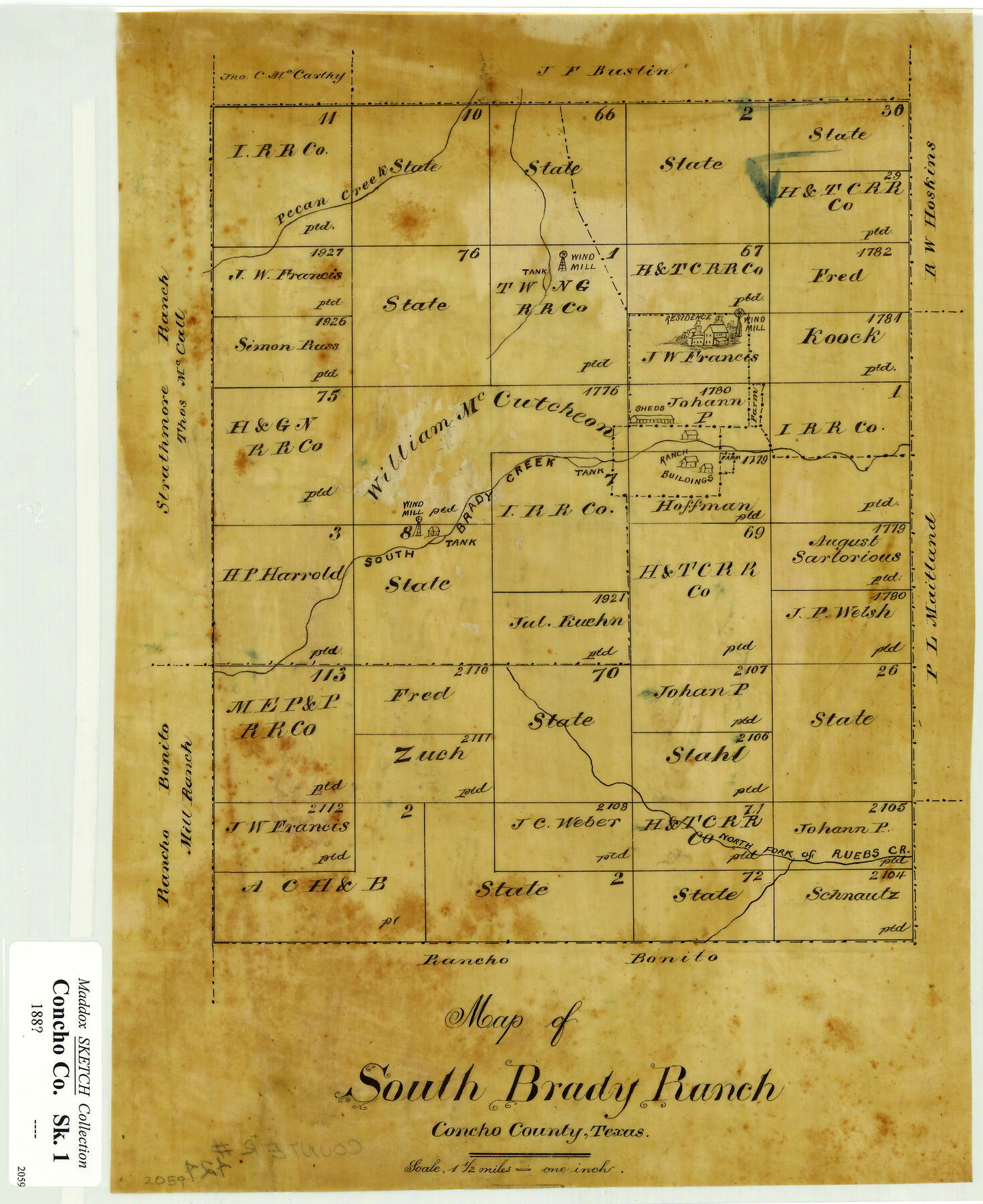
Map of South Brady Ranch, Concho County, Texas
-
Map/Doc
424
-
Collection
Maddox Collection
-
Object Dates
1880 (Creation Date)
-
Counties
Concho
-
Height x Width
12.9 x 10.5 inches
32.8 x 26.7 cm
-
Medium
paper, manuscript
-
Scale
1.5 miles = 1 inch
-
Features
North Fork of Ruebs Creek
South Brady Creek
Pecan Creek
Strathmore Ranch
Rancho Bonito
Mill Ranch
Part of: Maddox Collection
[Sketch Showing L. Gonzales, Wm. H. McBee and adjacent surveys, Kaufman County, Texas]
![5071, [Sketch Showing L. Gonzales, Wm. H. McBee and adjacent surveys, Kaufman County, Texas], Maddox Collection](https://historictexasmaps.com/wmedia_w700/maps/5071.tif.jpg)
Print $20.00
- Digital $50.00
[Sketch Showing L. Gonzales, Wm. H. McBee and adjacent surveys, Kaufman County, Texas]
Size 23.2 x 19.8 inches
Map/Doc 5071
[McK. & Williams No. 601 and surrounding surveys, Travis County]
![75553, [McK. & Williams No. 601 and surrounding surveys, Travis County], Maddox Collection](https://historictexasmaps.com/wmedia_w700/maps/75553.tif.jpg)
Print $3.00
- Digital $50.00
[McK. & Williams No. 601 and surrounding surveys, Travis County]
Size 16.3 x 10.7 inches
Map/Doc 75553
Part of original sketch of Block "H" W. & N. W. Ry. Co. Cottle County

Print $20.00
- Digital $50.00
Part of original sketch of Block "H" W. & N. W. Ry. Co. Cottle County
Size 14.3 x 15.6 inches
Map/Doc 613
Map of the Pitchfork Ranch

Print $20.00
- Digital $50.00
Map of the Pitchfork Ranch
1915
Size 39.9 x 35.9 inches
Map/Doc 75826
Map of Briscoe County, Texas

Print $20.00
- Digital $50.00
Map of Briscoe County, Texas
1879
Size 22.6 x 18.0 inches
Map/Doc 614
Map of Tyler County, Texas

Print $20.00
- Digital $50.00
Map of Tyler County, Texas
1881
Size 22.3 x 24.2 inches
Map/Doc 762
[Surveying Sketch of Part of] Maverick County
![515, [Surveying Sketch of Part of] Maverick County, Maddox Collection](https://historictexasmaps.com/wmedia_w700/maps/515.tif.jpg)
Print $3.00
- Digital $50.00
[Surveying Sketch of Part of] Maverick County
1878
Size 9.8 x 13.2 inches
Map/Doc 515
Map of Part of the YL Ranch

Print $20.00
- Digital $50.00
Map of Part of the YL Ranch
1917
Size 29.1 x 27.3 inches
Map/Doc 4442
[Marion County, Texas]
![75777, [Marion County, Texas], Maddox Collection](https://historictexasmaps.com/wmedia_w700/maps/75777.tif.jpg)
Print $20.00
- Digital $50.00
[Marion County, Texas]
1901
Size 26.5 x 24.1 inches
Map/Doc 75777
Map of the San Antonio del Encinal as Corrected

Print $20.00
- Digital $50.00
Map of the San Antonio del Encinal as Corrected
1916
Size 28.5 x 30.6 inches
Map/Doc 4456
Subdivision of the East Half of Lot No. 1 in Division "Z" of the Out-Lots adjoining the City of Austin

Print $20.00
- Digital $50.00
Subdivision of the East Half of Lot No. 1 in Division "Z" of the Out-Lots adjoining the City of Austin
Size 32.1 x 42.6 inches
Map/Doc 648
Part of original sketch of Block "H" W. & N. W. Ry. Co. Cottle County

Print $20.00
- Digital $50.00
Part of original sketch of Block "H" W. & N. W. Ry. Co. Cottle County
Size 13.7 x 14.6 inches
Map/Doc 10776
You may also like
Brazos River, Brazos River Sheet 1

Print $20.00
- Digital $50.00
Brazos River, Brazos River Sheet 1
1926
Size 20.7 x 25.3 inches
Map/Doc 69665
Llano County Sketch File 13

Print $4.00
- Digital $50.00
Llano County Sketch File 13
1891
Size 9.2 x 15.3 inches
Map/Doc 30387
Angelina County Sketch File 11c

Print $7.00
- Digital $50.00
Angelina County Sketch File 11c
Size 11.1 x 6.0 inches
Map/Doc 12946
Kaufman County Sketch File 10

Print $4.00
- Digital $50.00
Kaufman County Sketch File 10
1873
Size 10.2 x 8.2 inches
Map/Doc 28643
Brewster County Working Sketch 112

Print $20.00
- Digital $50.00
Brewster County Working Sketch 112
1982
Size 28.1 x 26.8 inches
Map/Doc 67712
Lamar County Sketch File 6

Print $40.00
- Digital $50.00
Lamar County Sketch File 6
Size 16.2 x 13.4 inches
Map/Doc 29286
[Cotton Belt, St. Louis Southwestern Railway of Texas, Alignment through Smith County]
![64387, [Cotton Belt, St. Louis Southwestern Railway of Texas, Alignment through Smith County], General Map Collection](https://historictexasmaps.com/wmedia_w700/maps/64387.tif.jpg)
Print $20.00
- Digital $50.00
[Cotton Belt, St. Louis Southwestern Railway of Texas, Alignment through Smith County]
1903
Size 21.7 x 29.5 inches
Map/Doc 64387
Medina County Rolled Sketch 3

Print $40.00
- Digital $50.00
Medina County Rolled Sketch 3
Size 40.9 x 54.5 inches
Map/Doc 9504
Llano County Working Sketch 4

Print $40.00
- Digital $50.00
Llano County Working Sketch 4
1954
Size 33.4 x 54.0 inches
Map/Doc 70622
Hudspeth County Rolled Sketch 69

Print $20.00
- Digital $50.00
Hudspeth County Rolled Sketch 69
1973
Size 12.2 x 20.8 inches
Map/Doc 7717
Terrell County

Print $20.00
- Digital $50.00
Terrell County
1905
Size 41.2 x 31.3 inches
Map/Doc 63060
Eastland County Working Sketch 16

Print $20.00
- Digital $50.00
Eastland County Working Sketch 16
1919
Size 19.1 x 16.7 inches
Map/Doc 68797