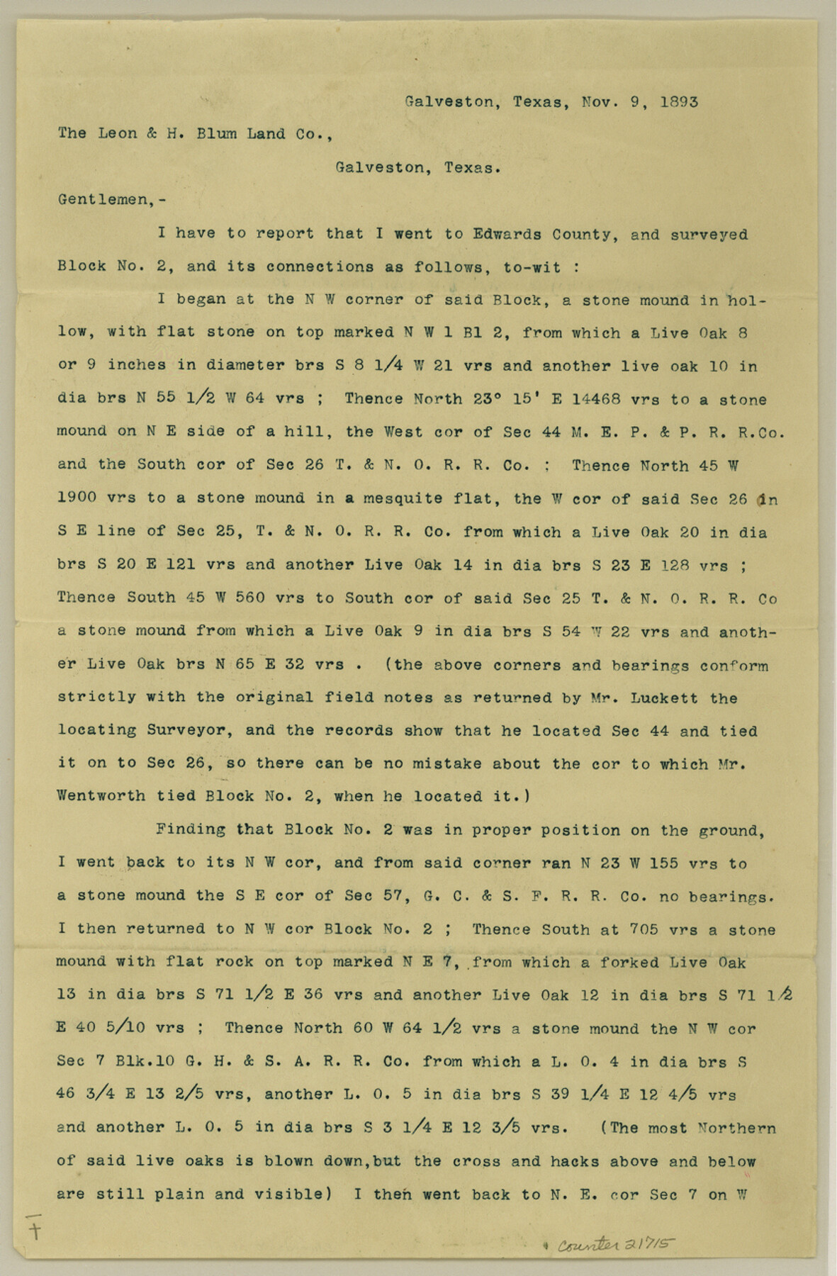
Edwards County Sketch File 15
[Field notes of a connecting line from Devil's sinkhole to Rock Spring surveys and thence to South Lano river surveys]
-
Map/Doc
21715
-
Collection
General Map Collection
-
Object Dates
1893/11/9 (Creation Date)
1893/11/27 (File Date)
-
People and Organizations
B.I. Wilcoxon (Surveyor/Engineer)
Mr. Luckett (Surveyor/Engineer)
Mr. Wentworth (Surveyor/Engineer)
Mr. Williams (Surveyor/Engineer)
-
Counties
Edwards
-
Subjects
Surveying Sketch File
-
Height x Width
12.9 x 8.5 inches
32.8 x 21.6 cm
-
Medium
paper, print
-
Features
Rock Springs
Rock Springs and Sonora Road
Devils Sink Hole
Sonora Road
Part of: General Map Collection

Motley County Sketch File 34 (S)

Print $20.00
- Digital $50.00
Motley County Sketch File 34 (S)
1951
Size 26.5 x 13.6 inches
Map/Doc 42149
Baylor County Sketch File A4

Print $8.00
- Digital $50.00
Baylor County Sketch File A4
Size 14.0 x 8.7 inches
Map/Doc 14084
Dickens County Working Sketch 4

Print $20.00
- Digital $50.00
Dickens County Working Sketch 4
1914
Size 27.9 x 18.8 inches
Map/Doc 68651
Aransas County Rolled Sketch 27B

Print $2.00
- Digital $50.00
Aransas County Rolled Sketch 27B
1958
Size 9.1 x 9.1 inches
Map/Doc 5057
Matagorda County Sketch File 21

Print $6.00
- Digital $50.00
Matagorda County Sketch File 21
1897
Size 14.2 x 8.7 inches
Map/Doc 30782
Intracoastal Waterway in Texas - Corpus Christi to Point Isabel including Arroyo Colorado to Mo. Pac. R.R. Bridge Near Harlingen

Print $20.00
- Digital $50.00
Intracoastal Waterway in Texas - Corpus Christi to Point Isabel including Arroyo Colorado to Mo. Pac. R.R. Bridge Near Harlingen
1933
Size 27.9 x 40.8 inches
Map/Doc 61878
Crosby County Working Sketch 14

Print $20.00
- Digital $50.00
Crosby County Working Sketch 14
1976
Size 41.6 x 32.3 inches
Map/Doc 68448
Flight Mission No. CRC-4R, Frame 112, Chambers County

Print $20.00
- Digital $50.00
Flight Mission No. CRC-4R, Frame 112, Chambers County
1956
Size 18.6 x 22.4 inches
Map/Doc 84909
Bee County Rolled Sketch 1

Print $20.00
- Digital $50.00
Bee County Rolled Sketch 1
2022
Size 24.4 x 36.0 inches
Map/Doc 97029
Midland County Rolled Sketch 14

Print $20.00
- Digital $50.00
Midland County Rolled Sketch 14
1996
Size 21.3 x 26.7 inches
Map/Doc 6769
Walker County Sketch File 1

Print $4.00
- Digital $50.00
Walker County Sketch File 1
1853
Size 9.7 x 8.3 inches
Map/Doc 39547
You may also like
Working Sketch Hemphill County

Print $20.00
- Digital $50.00
Working Sketch Hemphill County
1910
Size 6.9 x 39.1 inches
Map/Doc 90730
Dallas County Boundary File 2

Print $10.00
- Digital $50.00
Dallas County Boundary File 2
Size 11.2 x 8.4 inches
Map/Doc 52115
Outer Continental Shelf Leasing Maps (Louisiana Offshore Operations)

Print $20.00
- Digital $50.00
Outer Continental Shelf Leasing Maps (Louisiana Offshore Operations)
1971
Size 18.7 x 13.9 inches
Map/Doc 76102
Montgomery County Working Sketch 15

Print $40.00
- Digital $50.00
Montgomery County Working Sketch 15
1934
Size 51.8 x 41.6 inches
Map/Doc 71122
General Highway Map. Detail of Cities and Towns in Smith County, Texas. City Map, Tyler and vicinity, Smith County, Texas

Print $20.00
General Highway Map. Detail of Cities and Towns in Smith County, Texas. City Map, Tyler and vicinity, Smith County, Texas
1961
Size 18.2 x 24.9 inches
Map/Doc 79657
Flight Mission No. BRA-16M, Frame 96, Jefferson County

Print $20.00
- Digital $50.00
Flight Mission No. BRA-16M, Frame 96, Jefferson County
1953
Size 18.6 x 22.4 inches
Map/Doc 85708
Polk County Working Sketch 17

Print $20.00
- Digital $50.00
Polk County Working Sketch 17
1948
Size 28.3 x 18.5 inches
Map/Doc 71632
Terrell County Working Sketch 25

Print $40.00
- Digital $50.00
Terrell County Working Sketch 25
1942
Size 41.9 x 49.1 inches
Map/Doc 62175
Flight Mission No. DAG-24K, Frame 148, Matagorda County

Print $20.00
- Digital $50.00
Flight Mission No. DAG-24K, Frame 148, Matagorda County
1953
Size 18.5 x 22.2 inches
Map/Doc 86562
Presidio County Sketch File R1

Print $12.00
- Digital $50.00
Presidio County Sketch File R1
1927
Size 11.3 x 8.7 inches
Map/Doc 34599
Crockett County Sketch File 58

Print $20.00
- Digital $50.00
Crockett County Sketch File 58
1932
Size 17.9 x 23.2 inches
Map/Doc 11226
Zavala County Sketch File 47

Print $6.00
- Digital $50.00
Zavala County Sketch File 47
1937
Size 11.3 x 9.0 inches
Map/Doc 41430