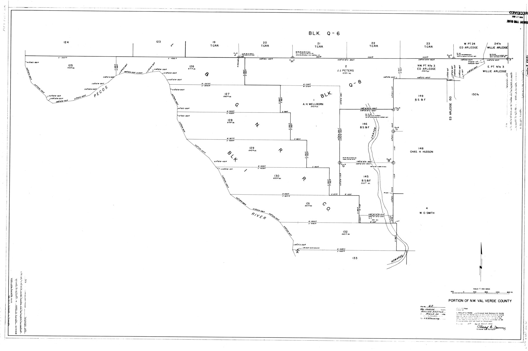
Val Verde County Rolled Sketch 62
Portion of N.W. Val Verde County
-
Map/Doc
10081
-
Collection
General Map Collection
-
Object Dates
3/5/1956 (Creation Date)
3/23/1956 (File Date)
-
People and Organizations
Phillip G. Young (Surveyor/Engineer)
-
Counties
Val Verde
-
Subjects
Surveying Rolled Sketch
-
Height x Width
34.6 x 52.1 inches
87.9 x 132.3 cm
-
Scale
1" = 360 varas
Related maps
Val Verde County Sketch File 50

Print $8.00
- Digital $50.00
Val Verde County Sketch File 50
1956
Size 11.5 x 8.9 inches
Map/Doc 39316
Part of: General Map Collection
Brewster County Rolled Sketch 59AA

Print $20.00
- Digital $50.00
Brewster County Rolled Sketch 59AA
1931
Size 19.2 x 24.0 inches
Map/Doc 5228
Hudspeth County Working Sketch 1

Print $40.00
- Digital $50.00
Hudspeth County Working Sketch 1
1911
Size 26.5 x 53.3 inches
Map/Doc 69023
Llano County Sketch File 2

Print $6.00
- Digital $50.00
Llano County Sketch File 2
Size 9.6 x 8.6 inches
Map/Doc 30347
Roberts County Boundary File 2e

Print $20.00
- Digital $50.00
Roberts County Boundary File 2e
Size 28.3 x 8.8 inches
Map/Doc 58367
Crockett County Sketch File 60

Print $22.00
- Digital $50.00
Crockett County Sketch File 60
1925
Size 11.4 x 8.7 inches
Map/Doc 19837
Flight Mission No. DAG-16K, Frame 74, Matagorda County

Print $20.00
- Digital $50.00
Flight Mission No. DAG-16K, Frame 74, Matagorda County
1952
Size 18.6 x 22.3 inches
Map/Doc 86320
Brooks County Boundary File 1c

Print $40.00
- Digital $50.00
Brooks County Boundary File 1c
Size 63.4 x 6.7 inches
Map/Doc 50838
Concho County Sketch File 5

Print $2.00
- Digital $50.00
Concho County Sketch File 5
1858
Size 8.1 x 7.4 inches
Map/Doc 82974

[Section of] Carte du Mexique et de la Nouvelle Espagne
![97485, [Section of] Carte du Mexique et de la Nouvelle Espagne, General Map Collection](https://historictexasmaps.com/wmedia_w700/maps/97485.tif.jpg)
[Section of] Carte du Mexique et de la Nouvelle Espagne
1779
Size 14.0 x 16.7 inches
Map/Doc 97485
Van Zandt County

Print $20.00
- Digital $50.00
Van Zandt County
1921
Size 46.7 x 41.4 inches
Map/Doc 63104
Flight Mission No. DAG-21K, Frame 106, Matagorda County

Print $20.00
- Digital $50.00
Flight Mission No. DAG-21K, Frame 106, Matagorda County
1952
Size 18.6 x 22.5 inches
Map/Doc 86434
You may also like
Map of Texas and Pacific Ry. Company's Surveys in the 80 Mile Reserve

Print $40.00
- Digital $50.00
Map of Texas and Pacific Ry. Company's Surveys in the 80 Mile Reserve
1885
Map/Doc 2241

State of Texas showing the Lower Rio Grande Valley

Print $20.00
- Digital $50.00
State of Texas showing the Lower Rio Grande Valley
1920
Size 14.0 x 13.4 inches
Map/Doc 95802
Flight Mission No. BRA-16M, Frame 113, Jefferson County

Print $20.00
- Digital $50.00
Flight Mission No. BRA-16M, Frame 113, Jefferson County
1953
Size 18.5 x 22.2 inches
Map/Doc 85723
Padre Island National Seashore

Print $4.00
- Digital $50.00
Padre Island National Seashore
Size 16.1 x 22.3 inches
Map/Doc 60535
Frio County Rolled Sketch 26

Print $20.00
- Digital $50.00
Frio County Rolled Sketch 26
1994
Size 28.1 x 38.9 inches
Map/Doc 5926
Fayette County Sketch File 7

Print $4.00
- Digital $50.00
Fayette County Sketch File 7
1873
Size 8.5 x 12.8 inches
Map/Doc 22547
[Gulf Coast portion of] Map of the State of Texas
![72707, [Gulf Coast portion of] Map of the State of Texas, General Map Collection](https://historictexasmaps.com/wmedia_w700/maps/72707.tif.jpg)
Print $20.00
- Digital $50.00
[Gulf Coast portion of] Map of the State of Texas
1865
Size 27.4 x 18.1 inches
Map/Doc 72707
Gregg County Sketch File 1E

Print $4.00
- Digital $50.00
Gregg County Sketch File 1E
1849
Size 12.6 x 8.2 inches
Map/Doc 24545
Red River County Working Sketch 71

Print $20.00
- Digital $50.00
Red River County Working Sketch 71
1977
Size 17.8 x 28.0 inches
Map/Doc 72054
Jasper County Working Sketch 24

Print $40.00
- Digital $50.00
Jasper County Working Sketch 24
1948
Size 46.9 x 56.2 inches
Map/Doc 66486
Eastland County Working Sketch 26

Print $20.00
- Digital $50.00
Eastland County Working Sketch 26
1948
Size 21.4 x 19.0 inches
Map/Doc 68807