Webb County Sketch File 14b
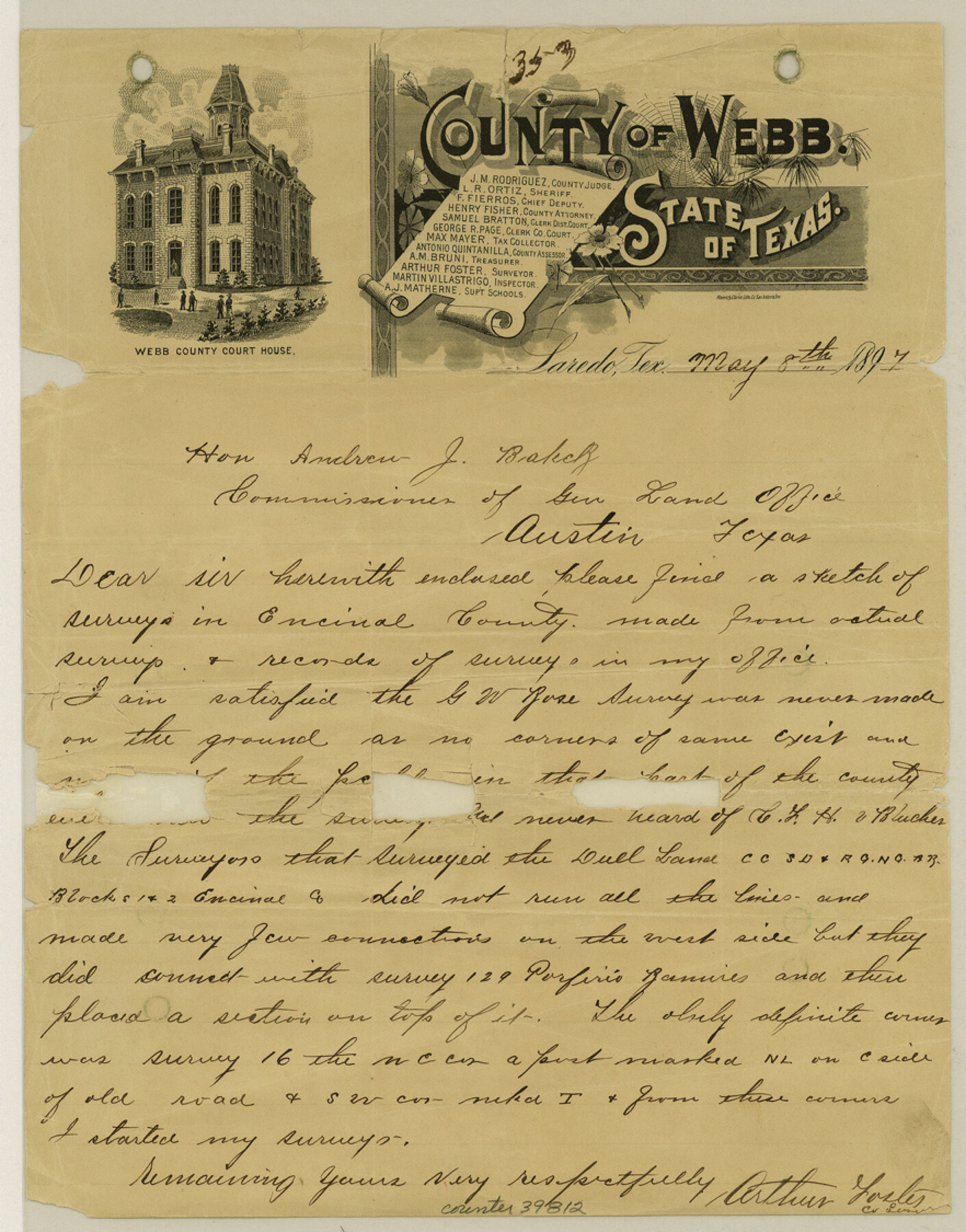
[Letter from surveyor regarding surveys and corners in the eastern part of the county]
-
Map/Doc
39812
-
Collection
General Map Collection
-
Object Dates
5/8/1897 (Creation Date)
-
People and Organizations
Arthur Foster (Surveyor/Engineer)
-
Counties
Webb
-
Subjects
Surveying Sketch File
-
Height x Width
11.2 x 8.8 inches
28.5 x 22.4 cm
-
Medium
paper, manuscript
Part of: General Map Collection
Midland County Sketch File 14

Print $8.00
- Digital $50.00
Midland County Sketch File 14
1951
Size 10.9 x 8.7 inches
Map/Doc 31578
Burnet County Sketch File 15

Print $4.00
- Digital $50.00
Burnet County Sketch File 15
Size 8.3 x 10.3 inches
Map/Doc 16702
Flight Mission No. DQN-5K, Frame 48, Calhoun County

Print $20.00
- Digital $50.00
Flight Mission No. DQN-5K, Frame 48, Calhoun County
1953
Size 18.7 x 22.2 inches
Map/Doc 84393
Chambers County NRC Article 33.136 Sketch 10

Print $44.00
- Digital $50.00
Chambers County NRC Article 33.136 Sketch 10
2014
Size 24.0 x 36.0 inches
Map/Doc 94498
Liberty County Working Sketch 72

Print $20.00
- Digital $50.00
Liberty County Working Sketch 72
1977
Size 25.8 x 28.7 inches
Map/Doc 70532
Dimmit County Working Sketch 41

Print $20.00
- Digital $50.00
Dimmit County Working Sketch 41
1971
Size 26.1 x 27.0 inches
Map/Doc 68702
Reagan County Working Sketch 47

Print $20.00
- Digital $50.00
Reagan County Working Sketch 47
1987
Size 23.9 x 43.8 inches
Map/Doc 71890
[Map of Parker County]
![3948, [Map of Parker County], General Map Collection](https://historictexasmaps.com/wmedia_w700/maps/3948.tif.jpg)
Print $20.00
- Digital $50.00
[Map of Parker County]
1889
Size 25.9 x 32.9 inches
Map/Doc 3948
Flight Mission No. CRC-3R, Frame 166, Chambers County

Print $20.00
- Digital $50.00
Flight Mission No. CRC-3R, Frame 166, Chambers County
1956
Size 18.8 x 22.4 inches
Map/Doc 84848
Aerial Perspective of Packery Channel

Print $20.00
- Digital $50.00
Aerial Perspective of Packery Channel
1938
Size 16.5 x 19.3 inches
Map/Doc 3001
[San Antonio & Aransas Pass Railway Co.]
![64261, [San Antonio & Aransas Pass Railway Co.], General Map Collection](https://historictexasmaps.com/wmedia_w700/maps/64261.tif.jpg)
Print $20.00
- Digital $50.00
[San Antonio & Aransas Pass Railway Co.]
Size 22.9 x 35.1 inches
Map/Doc 64261
Flight Mission No. BRE-2P, Frame 129, Nueces County

Print $20.00
- Digital $50.00
Flight Mission No. BRE-2P, Frame 129, Nueces County
1956
Size 18.6 x 22.7 inches
Map/Doc 86802
You may also like


Flight Mission No. DQN-1K, Frame 81, Calhoun County

Print $20.00
- Digital $50.00
Flight Mission No. DQN-1K, Frame 81, Calhoun County
1953
Size 18.4 x 22.1 inches
Map/Doc 84166
In the Supreme Court of the United States, The State of Oklahoma, Complainant vs. The State of Texas, Defendant, The United States of America, Intervener, Red River Valley, Texas and Oklahoma Between the 98th and 100th Meridians in Five Sheets, 1921

Print $40.00
- Digital $50.00
In the Supreme Court of the United States, The State of Oklahoma, Complainant vs. The State of Texas, Defendant, The United States of America, Intervener, Red River Valley, Texas and Oklahoma Between the 98th and 100th Meridians in Five Sheets, 1921
1921
Size 38.6 x 60.0 inches
Map/Doc 75276
Cameron County Rolled Sketch 19

Print $20.00
- Digital $50.00
Cameron County Rolled Sketch 19
Size 16.1 x 11.3 inches
Map/Doc 5468
Terrell County Working Sketch 48

Print $40.00
- Digital $50.00
Terrell County Working Sketch 48
1958
Size 59.3 x 42.2 inches
Map/Doc 62141
Texas 1972 Official Highway Travel Map

Digital $50.00
Texas 1972 Official Highway Travel Map
Size 28.2 x 36.4 inches
Map/Doc 94314
San Augustine County Working Sketch 11b

Print $20.00
- Digital $50.00
San Augustine County Working Sketch 11b
Size 18.9 x 26.3 inches
Map/Doc 63699
Randall County Rolled Sketch 8

Print $20.00
- Digital $50.00
Randall County Rolled Sketch 8
Size 25.7 x 35.6 inches
Map/Doc 7428
Flight Mission No. CUG-3P, Frame 143, Kleberg County

Print $20.00
- Digital $50.00
Flight Mission No. CUG-3P, Frame 143, Kleberg County
1956
Size 19.0 x 22.5 inches
Map/Doc 86278
Mapa de los Estados Unidos de Méjico, Segun lo organizado y definido por las varias actas del Congreso de dicha Republica: y construido por las mejores autoridades

Print $20.00
- Digital $50.00
Mapa de los Estados Unidos de Méjico, Segun lo organizado y definido por las varias actas del Congreso de dicha Republica: y construido por las mejores autoridades
1847
Size 31.2 x 42.9 inches
Map/Doc 93763
