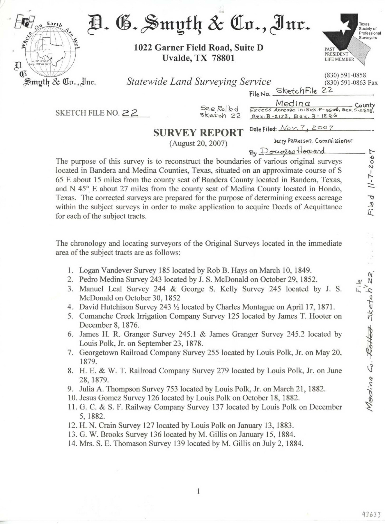
Medina County Sketch File 22
Survey report regarding excess acreage in BEX P-5606, BEX S-21658, BEX B-2123 and BEX 3-1266
-
Map/Doc
93633
-
Collection
General Map Collection
-
Object Dates
2007/8/20 (Creation Date)
2007/11/7 (File Date)
-
People and Organizations
David Gregory Smyth (Surveyor/Engineer)
Rob B. Hays (Surveyor/Engineer)
J.S. McDonald (Surveyor/Engineer)
Charles Montague (Surveyor/Engineer)
James T. Hooter (Surveyor/Engineer)
Louis Polk, Jr. (Surveyor/Engineer)
Louis Polk (Surveyor/Engineer)
M. Gillis (Surveyor/Engineer)
-
Counties
Medina Bandera
-
Subjects
Surveying Sketch File
-
Height x Width
11.0 x 8.5 inches
27.9 x 21.6 cm
-
Medium
multi-page, multi-format
-
Comments
See Medina County Rolled Sketch 22 (88849) for sketch.
Related maps
Medina County Rolled Sketch 22

Print $20.00
- Digital $50.00
Medina County Rolled Sketch 22
2007
Size 24.5 x 18.4 inches
Map/Doc 88849
Part of: General Map Collection
Flight Mission No. CUG-3P, Frame 16, Kleberg County

Print $20.00
- Digital $50.00
Flight Mission No. CUG-3P, Frame 16, Kleberg County
1956
Size 18.3 x 22.2 inches
Map/Doc 86226
Flight Mission No. DQN-3K, Frame 11, Calhoun County

Print $20.00
- Digital $50.00
Flight Mission No. DQN-3K, Frame 11, Calhoun County
1953
Size 18.6 x 22.2 inches
Map/Doc 84343
Donley County Sketch File B2

Print $20.00
- Digital $50.00
Donley County Sketch File B2
1918
Size 15.1 x 22.4 inches
Map/Doc 11372
Harrison County Working Sketch 15

Print $20.00
- Digital $50.00
Harrison County Working Sketch 15
1961
Size 25.7 x 18.0 inches
Map/Doc 66035
Runnels County

Print $40.00
- Digital $50.00
Runnels County
1948
Size 49.8 x 39.8 inches
Map/Doc 95629
Montgomery County Working Sketch 67

Print $20.00
- Digital $50.00
Montgomery County Working Sketch 67
1972
Size 35.0 x 29.6 inches
Map/Doc 71174
Stonewall County Sketch File C

Print $20.00
- Digital $50.00
Stonewall County Sketch File C
1886
Size 13.1 x 8.2 inches
Map/Doc 37196
Lampasas County Working Sketch 10

Print $20.00
- Digital $50.00
Lampasas County Working Sketch 10
1963
Size 32.2 x 42.9 inches
Map/Doc 70287
Terrell County Working Sketch 78

Print $20.00
- Digital $50.00
Terrell County Working Sketch 78
1983
Size 41.0 x 37.2 inches
Map/Doc 69599
[Beaumont, Sour Lake and Western Ry. Right of Way and Alignment - Frisco]
![64125, [Beaumont, Sour Lake and Western Ry. Right of Way and Alignment - Frisco], General Map Collection](https://historictexasmaps.com/wmedia_w700/maps/64125.tif.jpg)
Print $20.00
- Digital $50.00
[Beaumont, Sour Lake and Western Ry. Right of Way and Alignment - Frisco]
1910
Size 20.1 x 45.9 inches
Map/Doc 64125
Presidio County Rolled Sketch 84

Print $20.00
- Digital $50.00
Presidio County Rolled Sketch 84
1942
Size 22.7 x 33.1 inches
Map/Doc 9779
Reagan County Boundary File 1c

Print $56.00
- Digital $50.00
Reagan County Boundary File 1c
Size 9.2 x 8.2 inches
Map/Doc 58171
You may also like
Fisher County Sketch File 10

Print $20.00
- Digital $50.00
Fisher County Sketch File 10
Size 9.7 x 37.0 inches
Map/Doc 11477
La Salle County Working Sketch 8

Print $20.00
- Digital $50.00
La Salle County Working Sketch 8
1922
Size 19.0 x 18.3 inches
Map/Doc 70309
Anderson County Working Sketch 4

Print $20.00
- Digital $50.00
Anderson County Working Sketch 4
Size 15.9 x 21.4 inches
Map/Doc 67003
Terrell County Rolled Sketch 32

Print $20.00
- Digital $50.00
Terrell County Rolled Sketch 32
Size 20.6 x 25.4 inches
Map/Doc 7938
Amistad International Reservoir on Rio Grande 83

Print $20.00
- Digital $50.00
Amistad International Reservoir on Rio Grande 83
1949
Size 28.5 x 40.3 inches
Map/Doc 75512
Territory of New Mexico

Print $20.00
- Digital $50.00
Territory of New Mexico
1896
Size 43.4 x 36.5 inches
Map/Doc 76177
Township 2 North, Block 32]
![91211, Township 2 North, Block 32], Twichell Survey Records](https://historictexasmaps.com/wmedia_w700/maps/91211-1.tif.jpg)
Print $2.00
- Digital $50.00
Township 2 North, Block 32]
Size 9.0 x 13.7 inches
Map/Doc 91211
General Highway Map, Hill County, Texas

Print $20.00
General Highway Map, Hill County, Texas
1940
Size 25.0 x 18.6 inches
Map/Doc 79129
Presidio County Rolled Sketch 37

Print $20.00
- Digital $50.00
Presidio County Rolled Sketch 37
Size 15.6 x 22.6 inches
Map/Doc 7335
Real County Working Sketch 88

Print $20.00
- Digital $50.00
Real County Working Sketch 88
1989
Size 23.9 x 27.0 inches
Map/Doc 71980
Kenedy County Rolled Sketch 10

Print $20.00
- Digital $50.00
Kenedy County Rolled Sketch 10
1915
Size 21.7 x 35.7 inches
Map/Doc 6470
Intracoastal Waterway in Texas - Corpus Christi to Point Isabel including Arroyo Colorado to Mo. Pac. R.R. Bridge Near Harlingen

Print $20.00
- Digital $50.00
Intracoastal Waterway in Texas - Corpus Christi to Point Isabel including Arroyo Colorado to Mo. Pac. R.R. Bridge Near Harlingen
1934
Size 22.0 x 32.6 inches
Map/Doc 61886