Culberson County Sketch File 24
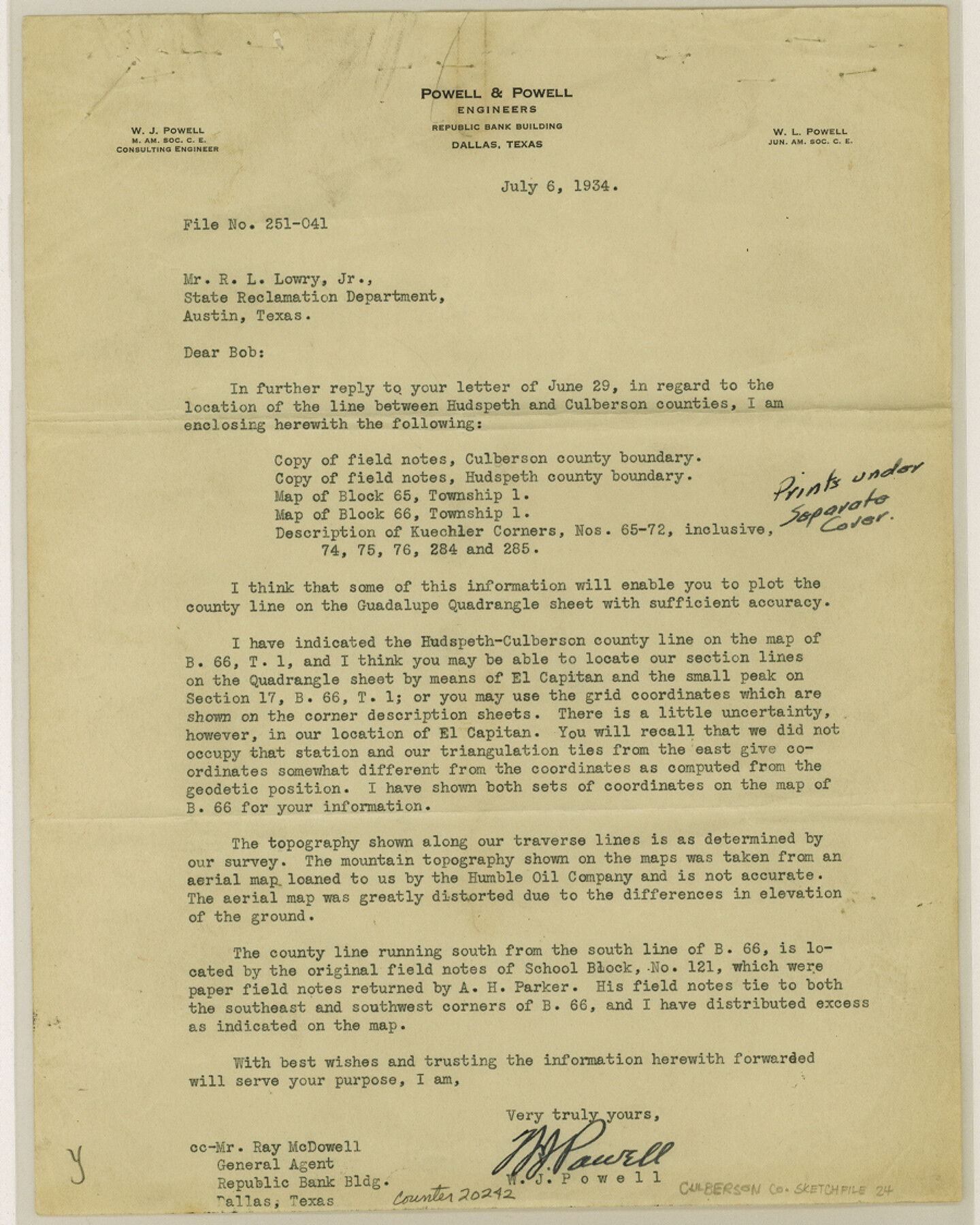
[Letter from W. J. Powell with description of corners in T. & P. RR. Co. Block 65, Township 1]
-
Map/Doc
20242
-
Collection
General Map Collection
-
Object Dates
1934/7/6 (Creation Date)
1944/11/3 (File Date)
-
People and Organizations
W.J. Powell (Surveyor/Engineer)
Kuechler (Surveyor/Engineer)
-
Counties
Culberson Hudspeth
-
Subjects
Surveying Sketch File
-
Height x Width
11.2 x 9.0 inches
28.4 x 22.9 cm
-
Medium
multi-page, multi-format
-
Comments
See Culberson County Rolled Sketch 40 (8751) for sketch.
-
Features
El Capitan
Rio Grande
Guadalupe Mountains
Guadalupe Peak
El Paso Stage Road
Related maps
Culberson County Rolled Sketch 40

Print $20.00
- Digital $50.00
Culberson County Rolled Sketch 40
Size 32.1 x 25.0 inches
Map/Doc 8751
Part of: General Map Collection
Little River, Widths of Floodways

Print $6.00
- Digital $50.00
Little River, Widths of Floodways
1921
Size 23.2 x 34.9 inches
Map/Doc 65070
Wilbarger County Sketch File 28

Print $20.00
- Digital $50.00
Wilbarger County Sketch File 28
2016
Size 23.9 x 36.2 inches
Map/Doc 95324
Menard County Rolled Sketch 2

Print $20.00
- Digital $50.00
Menard County Rolled Sketch 2
1883
Size 25.0 x 19.9 inches
Map/Doc 6752
Duval County Rolled Sketch 27

Print $40.00
- Digital $50.00
Duval County Rolled Sketch 27
Size 14.6 x 50.6 inches
Map/Doc 8814
Knox County Boundary File 4

Print $7.00
- Digital $50.00
Knox County Boundary File 4
Size 17.0 x 11.0 inches
Map/Doc 65037
Flight Mission No. DCL-7C, Frame 40, Kenedy County

Print $20.00
- Digital $50.00
Flight Mission No. DCL-7C, Frame 40, Kenedy County
1943
Size 15.4 x 15.2 inches
Map/Doc 86028
Travis County Working Sketch 61

Print $20.00
- Digital $50.00
Travis County Working Sketch 61
1995
Size 20.9 x 24.7 inches
Map/Doc 69445
El Paso County Working Sketch 59

Print $20.00
- Digital $50.00
El Paso County Working Sketch 59
2000
Size 28.1 x 35.7 inches
Map/Doc 69081
Map of New Brunswick and Nova Scotia / Map of Newfoundland / Map of the West Indies, Guatimala and part of Mexico to illustrate Olney's school geography

Print $20.00
- Digital $50.00
Map of New Brunswick and Nova Scotia / Map of Newfoundland / Map of the West Indies, Guatimala and part of Mexico to illustrate Olney's school geography
1844
Size 9.5 x 12.1 inches
Map/Doc 93544
Connected Map of Austin's Colony

Print $20.00
- Digital $50.00
Connected Map of Austin's Colony
1892
Size 47.3 x 43.3 inches
Map/Doc 76075
Map of Surveys Made for the T&PRR in Andrews & Martin Counties, Blocks 37, 38, 39, 40 & 41, Reserve West of the Colorado River

Print $20.00
- Digital $50.00
Map of Surveys Made for the T&PRR in Andrews & Martin Counties, Blocks 37, 38, 39, 40 & 41, Reserve West of the Colorado River
1876
Size 42.0 x 36.8 inches
Map/Doc 2229
University Lands, Hudspeth County, Texas, Blocks A to N

Print $40.00
- Digital $50.00
University Lands, Hudspeth County, Texas, Blocks A to N
1935
Size 39.0 x 55.5 inches
Map/Doc 2413
You may also like
Kerr County Rolled Sketch 11A

Print $20.00
- Digital $50.00
Kerr County Rolled Sketch 11A
1950
Size 27.8 x 36.0 inches
Map/Doc 6496
Cameron County Rolled Sketch 21

Print $20.00
- Digital $50.00
Cameron County Rolled Sketch 21
1952
Size 27.3 x 40.2 inches
Map/Doc 8573
Flight Mission No. DAG-21K, Frame 34, Matagorda County

Print $20.00
- Digital $50.00
Flight Mission No. DAG-21K, Frame 34, Matagorda County
1952
Size 18.7 x 22.3 inches
Map/Doc 86401
Flight Mission No. BQR-13K, Frame 20, Brazoria County

Print $20.00
- Digital $50.00
Flight Mission No. BQR-13K, Frame 20, Brazoria County
1952
Size 18.9 x 22.5 inches
Map/Doc 84068
Aransas County Rolled Sketch 16

Print $40.00
- Digital $50.00
Aransas County Rolled Sketch 16
1965
Size 45.9 x 92.9 inches
Map/Doc 9005
Flight Mission No. DAG-24K, Frame 51, Matagorda County

Print $20.00
- Digital $50.00
Flight Mission No. DAG-24K, Frame 51, Matagorda County
1953
Size 16.0 x 15.9 inches
Map/Doc 86538
Val Verde County Working Sketch 34

Print $20.00
- Digital $50.00
Val Verde County Working Sketch 34
1940
Size 33.7 x 27.9 inches
Map/Doc 72169
Glasscock County Sketch File 2

Print $20.00
- Digital $50.00
Glasscock County Sketch File 2
1931
Size 35.1 x 16.2 inches
Map/Doc 11559
Matagorda County Boundary File 1a

Print $8.00
- Digital $50.00
Matagorda County Boundary File 1a
Size 14.2 x 8.6 inches
Map/Doc 56889
Working Sketch in Crosby Co.

Print $20.00
- Digital $50.00
Working Sketch in Crosby Co.
1906
Size 17.5 x 17.9 inches
Map/Doc 90350
Karnes County Working Sketch 11

Print $40.00
- Digital $50.00
Karnes County Working Sketch 11
1975
Size 38.1 x 53.6 inches
Map/Doc 66659
Glasscock County Sketch File 20

Print $40.00
- Digital $50.00
Glasscock County Sketch File 20
1935
Size 15.6 x 12.6 inches
Map/Doc 24196