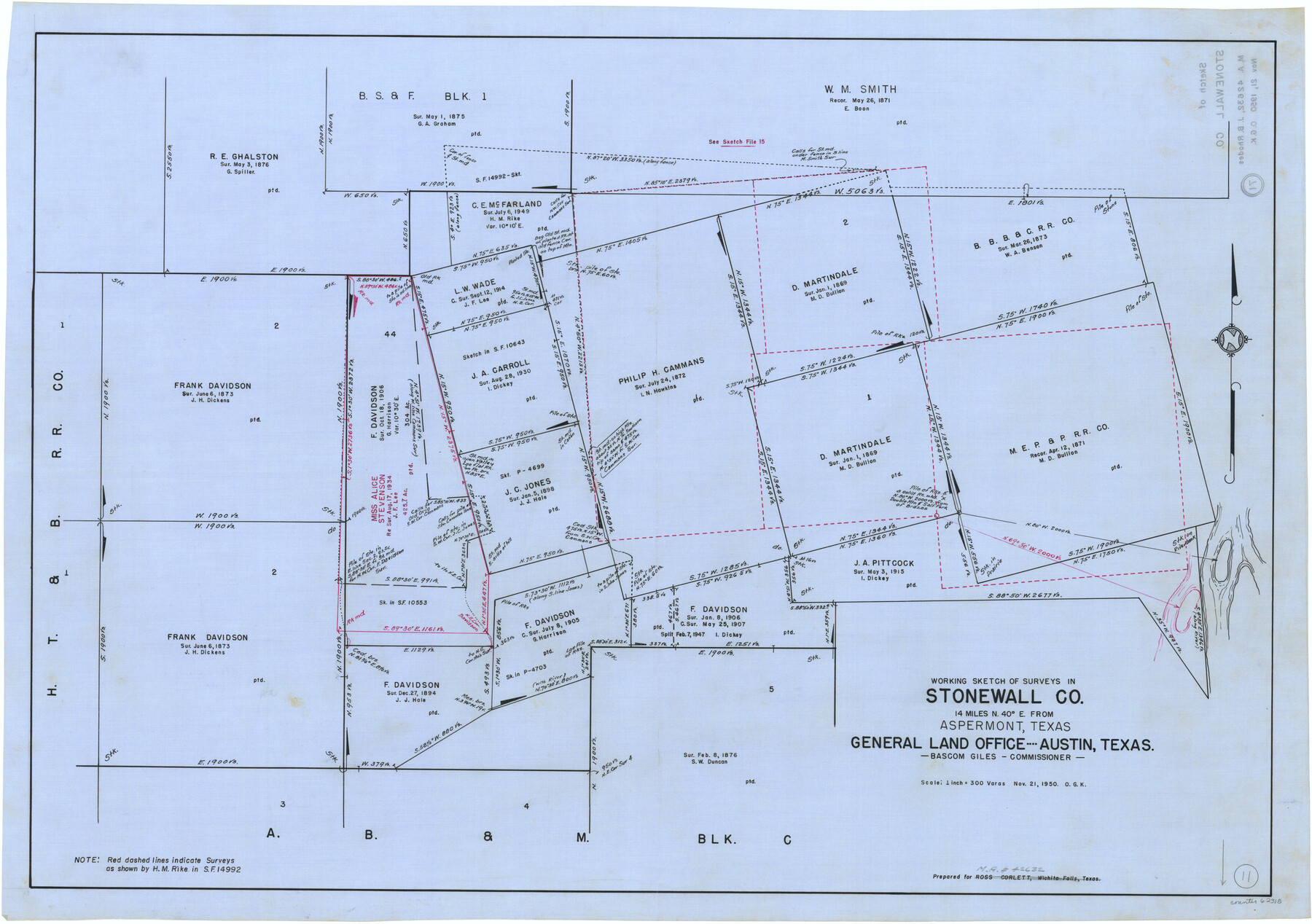
Stonewall County Working Sketch 11
-
Map/Doc
62318
-
Collection
General Map Collection
-
Object Dates
11/21/1950 (Creation Date)
-
People and Organizations
Otto G. Kurio (Draftsman)
-
Counties
Stonewall
-
Subjects
Surveying Working Sketch
-
Height x Width
23.8 x 33.7 inches
60.5 x 85.6 cm
-
Scale
1" = 300 varas
Part of: General Map Collection
Matagorda Bay and Approaches

Print $20.00
- Digital $50.00
Matagorda Bay and Approaches
1974
Size 35.1 x 44.6 inches
Map/Doc 73386
Map of Menard County

Print $20.00
- Digital $50.00
Map of Menard County
1871
Size 18.5 x 23.3 inches
Map/Doc 3872
Shelby County Rolled Sketch 2

Print $20.00
- Digital $50.00
Shelby County Rolled Sketch 2
Size 20.3 x 30.7 inches
Map/Doc 7775
Current Miscellaneous File 37

Print $4.00
- Digital $50.00
Current Miscellaneous File 37
Size 13.2 x 8.7 inches
Map/Doc 73956
Jeff Davis County Sketch File 44

Print $8.00
- Digital $50.00
Jeff Davis County Sketch File 44
1886
Size 8.5 x 8.0 inches
Map/Doc 28071
Polk County Working Sketch 40

Print $20.00
- Digital $50.00
Polk County Working Sketch 40
1983
Size 25.4 x 27.3 inches
Map/Doc 71657
Garza County Rolled Sketch R3

Print $20.00
- Digital $50.00
Garza County Rolled Sketch R3
Size 21.4 x 14.9 inches
Map/Doc 6006
Map of Brownsville Navigation District survey in Cameron County showing area for mineral development

Print $20.00
- Digital $50.00
Map of Brownsville Navigation District survey in Cameron County showing area for mineral development
1938
Size 22.3 x 36.5 inches
Map/Doc 2731
Brazoria County Working Sketch 49a

Print $20.00
- Digital $50.00
Brazoria County Working Sketch 49a
2003
Size 35.0 x 35.0 inches
Map/Doc 78347
Brazos River, Brazos River Sheet 2

Print $20.00
- Digital $50.00
Brazos River, Brazos River Sheet 2
1926
Size 22.3 x 29.4 inches
Map/Doc 69666
Somervell County Sketch File 6

Print $6.00
- Digital $50.00
Somervell County Sketch File 6
1939
Size 13.6 x 8.6 inches
Map/Doc 36847
Terrell County Working Sketch 67

Print $20.00
- Digital $50.00
Terrell County Working Sketch 67
1973
Size 32.8 x 28.2 inches
Map/Doc 69588
You may also like
Map of Texas, compiled from surveys on record in the General Land Office of the Republic

Print $20.00
Map of Texas, compiled from surveys on record in the General Land Office of the Republic
1847
Size 32.2 x 25.0 inches
Map/Doc 79325
Rio Grande, Harlingen Sheet

Print $20.00
- Digital $50.00
Rio Grande, Harlingen Sheet
1935
Size 37.2 x 37.2 inches
Map/Doc 65113
Navarro County Sketch File 13

Print $22.00
- Digital $50.00
Navarro County Sketch File 13
Size 12.0 x 8.6 inches
Map/Doc 32324
Freestone County Rolled Sketch 3

Print $67.00
- Digital $50.00
Freestone County Rolled Sketch 3
Size 10.4 x 15.5 inches
Map/Doc 44784
Lamar County Sketch File 15

Print $134.00
- Digital $50.00
Lamar County Sketch File 15
1989
Size 14.5 x 9.1 inches
Map/Doc 29310
[Sketch of Blocks D5-D8]
![93046, [Sketch of Blocks D5-D8], Twichell Survey Records](https://historictexasmaps.com/wmedia_w700/maps/93046-1.tif.jpg)
Print $20.00
- Digital $50.00
[Sketch of Blocks D5-D8]
Size 43.1 x 28.3 inches
Map/Doc 93046
Upton County Rolled Sketch 55

Print $40.00
- Digital $50.00
Upton County Rolled Sketch 55
Size 192.5 x 25.4 inches
Map/Doc 10060
Atascosa County Sketch File 3b

Print $8.00
- Digital $50.00
Atascosa County Sketch File 3b
1857
Size 11.4 x 5.8 inches
Map/Doc 13739
Wise County Sketch File 18

Print $4.00
- Digital $50.00
Wise County Sketch File 18
1860
Size 12.8 x 7.8 inches
Map/Doc 40553
[Titles along the Trinity River]
![175, [Titles along the Trinity River], General Map Collection](https://historictexasmaps.com/wmedia_w700/maps/175.tif.jpg)
Print $3.00
- Digital $50.00
[Titles along the Trinity River]
Size 10.6 x 15.8 inches
Map/Doc 175
[Surveys in the Travis District along the Colorado and Pedernales Rivers]
![113, [Surveys in the Travis District along the Colorado and Pedernales Rivers], General Map Collection](https://historictexasmaps.com/wmedia_w700/maps/113.tif.jpg)
Print $2.00
- Digital $50.00
[Surveys in the Travis District along the Colorado and Pedernales Rivers]
1841
Size 9.9 x 8.2 inches
Map/Doc 113
Comal County Working Sketch 6

Print $20.00
- Digital $50.00
Comal County Working Sketch 6
1950
Size 25.1 x 24.2 inches
Map/Doc 68172