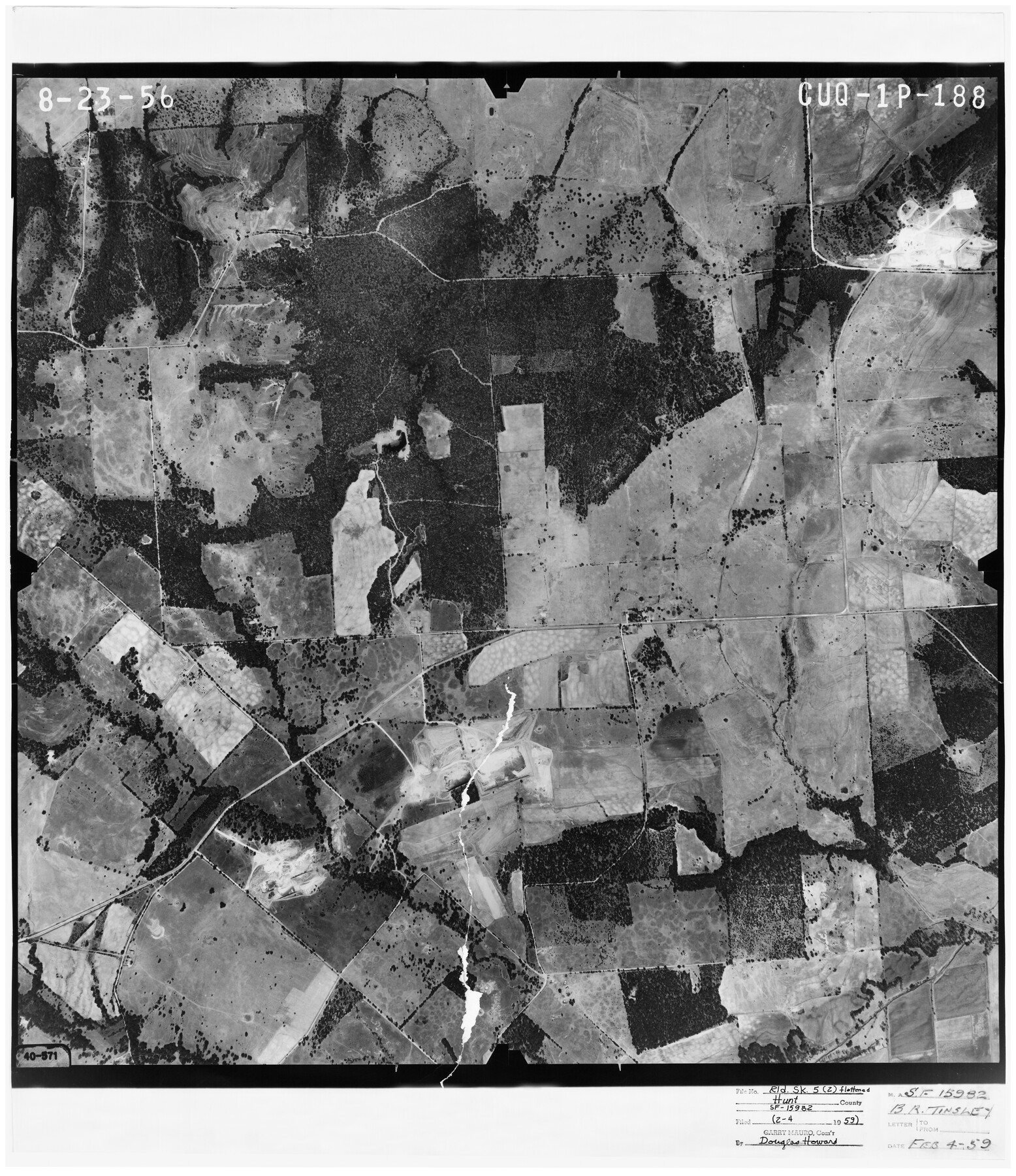
Hunt County Rolled Sketch 5
[Aerial photo relating to SF-15982]
-
Map/Doc
6269
-
Collection
General Map Collection
-
Object Dates
8/23/1956 (Creation Date)
2/4/1959 (File Date)
-
Counties
Hunt
-
Subjects
Surveying Rolled Sketch
-
Height x Width
27.5 x 24.3 inches
69.9 x 61.7 cm
-
Medium
photograph
Part of: General Map Collection
Aransas County Rolled Sketch 9

Digital $50.00
Aransas County Rolled Sketch 9
Size 85.3 x 41.9 inches
Map/Doc 8409
Wichita County Rolled Sketch 9

Print $20.00
- Digital $50.00
Wichita County Rolled Sketch 9
1917
Size 28.0 x 27.7 inches
Map/Doc 8246
Knox County Working Sketch 20

Print $20.00
- Digital $50.00
Knox County Working Sketch 20
2012
Size 40.2 x 36.9 inches
Map/Doc 93389
Dickens County Sketch File 37

Print $8.00
- Digital $50.00
Dickens County Sketch File 37
Size 10.3 x 8.3 inches
Map/Doc 21044
Kenedy County Rolled Sketch 3

Print $40.00
- Digital $50.00
Kenedy County Rolled Sketch 3
1904
Size 40.1 x 57.4 inches
Map/Doc 9329
Brazoria County NRC Article 33.136 Sketch 19

Print $28.00
- Digital $50.00
Brazoria County NRC Article 33.136 Sketch 19
2018
Size 18.0 x 24.0 inches
Map/Doc 95376
Sutton County Sketch File 47

Print $4.00
- Digital $50.00
Sutton County Sketch File 47
1939
Size 11.4 x 8.8 inches
Map/Doc 37519
Edwards County Rolled Sketch 37

Print $20.00
- Digital $50.00
Edwards County Rolled Sketch 37
2018
Size 23.3 x 30.2 inches
Map/Doc 94459
Maps of Gulf Intracoastal Waterway, Texas - Sabine River to the Rio Grande and connecting waterways including ship channels

Print $20.00
- Digital $50.00
Maps of Gulf Intracoastal Waterway, Texas - Sabine River to the Rio Grande and connecting waterways including ship channels
1966
Size 14.6 x 22.2 inches
Map/Doc 61979
Dickens County Sketch File GW3

Print $40.00
- Digital $50.00
Dickens County Sketch File GW3
Size 13.9 x 26.6 inches
Map/Doc 11335
[Surveys along the Jefferson and Jasper County Boundary]
![92, [Surveys along the Jefferson and Jasper County Boundary], General Map Collection](https://historictexasmaps.com/wmedia_w700/maps/92.tif.jpg)
Print $3.00
- Digital $50.00
[Surveys along the Jefferson and Jasper County Boundary]
1841
Size 11.8 x 16.3 inches
Map/Doc 92
Flight Mission No. DCL-7C, Frame 10, Kenedy County

Print $20.00
- Digital $50.00
Flight Mission No. DCL-7C, Frame 10, Kenedy County
1943
Size 15.3 x 15.2 inches
Map/Doc 86002
You may also like
Hays County Sketch File 5

Print $4.00
- Digital $50.00
Hays County Sketch File 5
1847
Size 12.7 x 8.3 inches
Map/Doc 26206
General Highway Map, Red River County, Texas

Print $20.00
General Highway Map, Red River County, Texas
1940
Size 25.0 x 18.3 inches
Map/Doc 79226
[Southwest corner Runnels County School Land League 3 and vicinity]
![93115, [Southwest corner Runnels County School Land League 3 and vicinity], Twichell Survey Records](https://historictexasmaps.com/wmedia_w700/maps/93115-1.tif.jpg)
Print $20.00
- Digital $50.00
[Southwest corner Runnels County School Land League 3 and vicinity]
Size 42.6 x 32.0 inches
Map/Doc 93115
Smith County Rolled Sketch 6

Print $20.00
- Digital $50.00
Smith County Rolled Sketch 6
1999
Size 43.3 x 30.0 inches
Map/Doc 10699
Reeves County Sketch File 6

Print $20.00
- Digital $50.00
Reeves County Sketch File 6
Size 17.3 x 28.3 inches
Map/Doc 12242
Yoakum County Sketch File 3

Print $54.00
- Digital $50.00
Yoakum County Sketch File 3
1892
Size 14.2 x 8.8 inches
Map/Doc 40705
Montgomery County Sketch File 27

Print $20.00
- Digital $50.00
Montgomery County Sketch File 27
1932
Size 37.3 x 41.9 inches
Map/Doc 10548
Archer County

Print $20.00
- Digital $50.00
Archer County
1926
Size 43.8 x 38.7 inches
Map/Doc 77202
Uvalde County Rolled Sketch 19

Print $20.00
- Digital $50.00
Uvalde County Rolled Sketch 19
Size 21.9 x 20.2 inches
Map/Doc 8103
Cottle County Sketch File 6

Print $20.00
- Digital $50.00
Cottle County Sketch File 6
1883
Size 20.3 x 29.8 inches
Map/Doc 11190
Bee County Boundary File 4

Print $22.00
- Digital $50.00
Bee County Boundary File 4
Size 12.9 x 8.1 inches
Map/Doc 50441
Working Sketch Compiled from Original Field Notes Irion County, Texas

Print $20.00
- Digital $50.00
Working Sketch Compiled from Original Field Notes Irion County, Texas
Size 19.4 x 19.5 inches
Map/Doc 92187