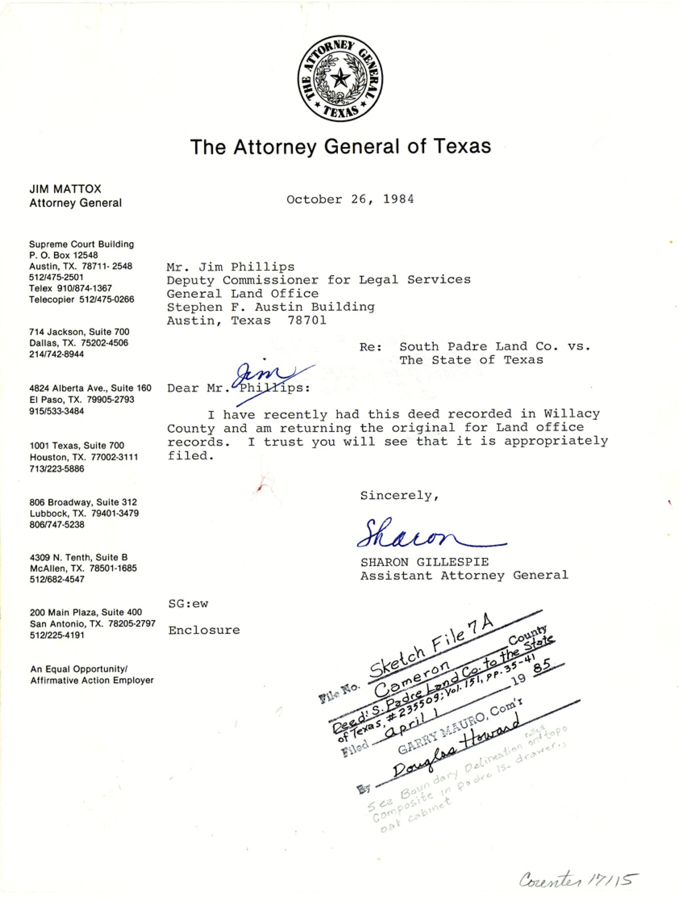
Cameron County Sketch File 7a
[Deed - South Padre Land Company to the State of Texas]
-
Map/Doc
17115
-
Collection
General Map Collection
-
Object Dates
1982/3/3 (Creation Date)
1985/4/1 (File Date)
-
Counties
Willacy
-
Subjects
Surveying Sketch File
-
Height x Width
11.2 x 8.4 inches
28.4 x 21.3 cm
-
Medium
paper, photocopy
-
Features
Port Mansfield Ship Channel
Raymondville
Padre Island
Laguna Madre
Part of: General Map Collection
Bee County Working Sketch 5

Print $20.00
- Digital $50.00
Bee County Working Sketch 5
1930
Size 21.1 x 14.5 inches
Map/Doc 67255
Texas Official Travel Map

Digital $50.00
Texas Official Travel Map
Size 33.6 x 36.5 inches
Map/Doc 94301
Galveston County Working Sketch 5

Print $20.00
- Digital $50.00
Galveston County Working Sketch 5
1934
Size 41.2 x 41.0 inches
Map/Doc 69342
Wilson County Sketch File 3

Print $6.00
- Digital $50.00
Wilson County Sketch File 3
1848
Size 13.3 x 8.6 inches
Map/Doc 40399
Montgomery County Sketch File 5

Print $5.00
- Digital $50.00
Montgomery County Sketch File 5
Size 9.8 x 16.4 inches
Map/Doc 31779
Duval County Sketch File 46

Print $4.00
- Digital $50.00
Duval County Sketch File 46
Size 8.8 x 9.4 inches
Map/Doc 21400
Little River, Cameron Sheet

Print $4.00
- Digital $50.00
Little River, Cameron Sheet
1914
Size 28.3 x 24.4 inches
Map/Doc 65062
[Nueces Bay Islands and Nesting Birds]
![60312, [Nueces Bay Islands and Nesting Birds], General Map Collection](https://historictexasmaps.com/wmedia_w700/maps/60312.tif.jpg)
Print $2.00
- Digital $50.00
[Nueces Bay Islands and Nesting Birds]
1940
Size 11.4 x 7.2 inches
Map/Doc 60312
Atascosa County Rolled Sketch 22

Print $40.00
- Digital $50.00
Atascosa County Rolled Sketch 22
1917
Size 57.5 x 26.5 inches
Map/Doc 8921
Presidio County Rolled Sketch 94

Print $20.00
- Digital $50.00
Presidio County Rolled Sketch 94
Size 18.1 x 24.5 inches
Map/Doc 7380
Winkler County Working Sketch 21

Print $20.00
- Digital $50.00
Winkler County Working Sketch 21
2015
Size 33.2 x 45.7 inches
Map/Doc 93728
Blanco County Working Sketch 6

Print $20.00
- Digital $50.00
Blanco County Working Sketch 6
1923
Size 17.6 x 12.5 inches
Map/Doc 67365
You may also like
Lipscomb County Boundary File 14b

Print $60.00
- Digital $50.00
Lipscomb County Boundary File 14b
Size 7.3 x 8.7 inches
Map/Doc 56370
[H. & G. N. Block 1]
![90941, [H. & G. N. Block 1], Twichell Survey Records](https://historictexasmaps.com/wmedia_w700/maps/90941-1.tif.jpg)
Print $20.00
- Digital $50.00
[H. & G. N. Block 1]
1873
Size 17.5 x 14.3 inches
Map/Doc 90941
Flight Mission No. DAG-26K, Frame 83, Matagorda County

Print $20.00
- Digital $50.00
Flight Mission No. DAG-26K, Frame 83, Matagorda County
1953
Size 18.6 x 19.6 inches
Map/Doc 86588
Flight Mission No. CRC-3R, Frame 195, Chambers County

Print $20.00
- Digital $50.00
Flight Mission No. CRC-3R, Frame 195, Chambers County
1956
Size 18.5 x 22.2 inches
Map/Doc 84850
San Saba County Sketch File 16

Print $20.00
- Digital $50.00
San Saba County Sketch File 16
1902
Size 16.9 x 18.8 inches
Map/Doc 12294
Clayton Carter Addition, North 84.9 Acres of Section 77, Block A

Print $20.00
- Digital $50.00
Clayton Carter Addition, North 84.9 Acres of Section 77, Block A
1945
Size 30.1 x 9.6 inches
Map/Doc 92767
Presidio County Working Sketch 133

Print $20.00
- Digital $50.00
Presidio County Working Sketch 133
1989
Size 31.7 x 42.8 inches
Map/Doc 71811

Ownership Map SE 1/4 Lubbock County

Print $20.00
- Digital $50.00
Ownership Map SE 1/4 Lubbock County
Size 36.6 x 35.9 inches
Map/Doc 89898
Crawford Farm S 1/2 Section 59, Block A

Print $3.00
- Digital $50.00
Crawford Farm S 1/2 Section 59, Block A
Size 16.5 x 9.9 inches
Map/Doc 92337
Mills County Boundary File 2

Print $6.00
- Digital $50.00
Mills County Boundary File 2
Size 14.1 x 8.7 inches
Map/Doc 57278
Young County Working Sketch 17

Print $20.00
- Digital $50.00
Young County Working Sketch 17
1958
Size 20.7 x 28.6 inches
Map/Doc 62040