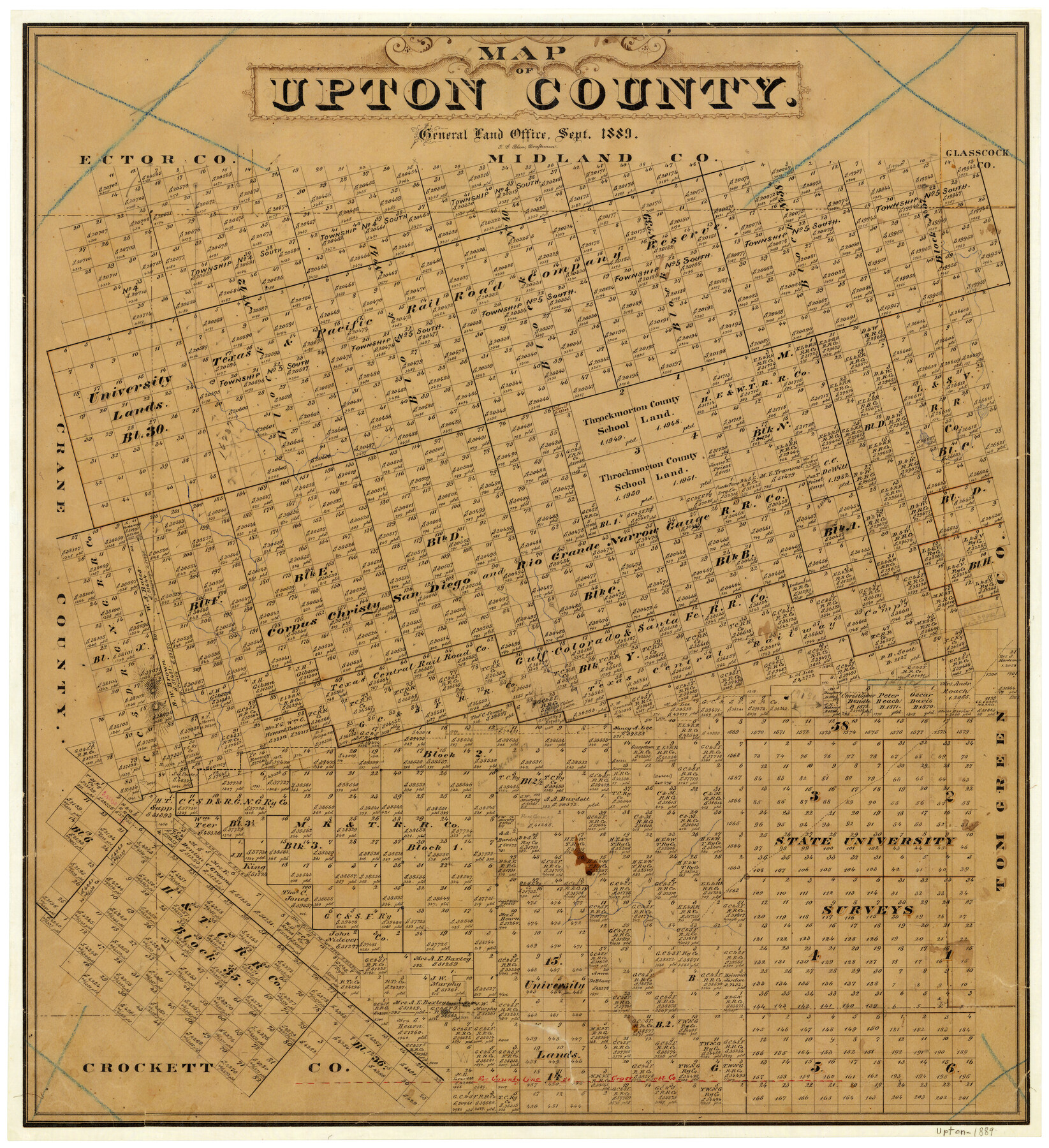
Map of Upton County
-
Map/Doc
4104
-
Collection
General Map Collection
-
Object Dates
9/1889 (Creation Date)
-
People and Organizations
Texas General Land Office (Publisher)
F.G. Blau (Compiler)
F.G. Blau (Draftsman)
-
Counties
Upton
-
Subjects
County
-
Height x Width
23.4 x 21.4 inches
59.4 x 54.4 cm
-
Features
Sugarloaf [sic] Mountains
Part of: General Map Collection
Gulf of Mexico

Print $20.00
- Digital $50.00
Gulf of Mexico
1900
Size 18.4 x 28.1 inches
Map/Doc 72649
Hunt County Boundary File 10a

Print $40.00
- Digital $50.00
Hunt County Boundary File 10a
Size 42.1 x 10.5 inches
Map/Doc 55262
Flight Mission No. DQN-3K, Frame 10, Calhoun County

Print $20.00
- Digital $50.00
Flight Mission No. DQN-3K, Frame 10, Calhoun County
1953
Size 18.5 x 22.2 inches
Map/Doc 84342
Lamb County Sketch File 12

Print $16.00
- Digital $50.00
Lamb County Sketch File 12
Size 8.6 x 7.7 inches
Map/Doc 29363

DeWitt County Working Sketch 10

Print $20.00
- Digital $50.00
DeWitt County Working Sketch 10
1980
Size 15.1 x 12.0 inches
Map/Doc 68600
Flight Mission No. BRA-7M, Frame 206, Jefferson County

Print $20.00
- Digital $50.00
Flight Mission No. BRA-7M, Frame 206, Jefferson County
1953
Size 18.6 x 22.2 inches
Map/Doc 85574
Flight Mission No. DAG-14K, Frame 41, Matagorda County

Print $20.00
- Digital $50.00
Flight Mission No. DAG-14K, Frame 41, Matagorda County
1952
Size 18.6 x 22.4 inches
Map/Doc 86299
Parker County Sketch File 3a

Print $40.00
- Digital $50.00
Parker County Sketch File 3a
Size 12.7 x 12.8 inches
Map/Doc 33523
[Beaumont, Sour Lake and Western Ry. Right of Way and Alignment - Frisco]
![64117, [Beaumont, Sour Lake and Western Ry. Right of Way and Alignment - Frisco], General Map Collection](https://historictexasmaps.com/wmedia_w700/maps/64117.tif.jpg)
Print $20.00
- Digital $50.00
[Beaumont, Sour Lake and Western Ry. Right of Way and Alignment - Frisco]
1910
Size 20.2 x 45.9 inches
Map/Doc 64117
Flight Mission No. CGI-8AA, Frame 146, Cameron County

Print $20.00
- Digital $50.00
Flight Mission No. CGI-8AA, Frame 146, Cameron County
1962
Size 18.6 x 18.3 inches
Map/Doc 84533
Mills County Working Sketch 24

Print $20.00
- Digital $50.00
Mills County Working Sketch 24
1988
Size 40.3 x 36.5 inches
Map/Doc 71054
You may also like
San Jacinto County Working Sketch 31

Print $20.00
- Digital $50.00
San Jacinto County Working Sketch 31
1953
Size 29.1 x 30.4 inches
Map/Doc 63744
[LIT Ranch, Gunter & Munson surveys 52-55, Canadian River Meander]
![93011, [LIT Ranch, Gunter & Munson surveys 52-55, Canadian River Meander], Twichell Survey Records](https://historictexasmaps.com/wmedia_w700/maps/93011-1.tif.jpg)
Print $20.00
- Digital $50.00
[LIT Ranch, Gunter & Munson surveys 52-55, Canadian River Meander]
Size 18.4 x 12.8 inches
Map/Doc 93011
Brewster County Sketch File N-17

Print $80.00
- Digital $50.00
Brewster County Sketch File N-17
1939
Size 8.9 x 14.4 inches
Map/Doc 15651
Flight Mission No. DQN-2K, Frame 69, Calhoun County

Print $20.00
- Digital $50.00
Flight Mission No. DQN-2K, Frame 69, Calhoun County
1953
Size 16.2 x 16.1 inches
Map/Doc 84261
Navarro County Sketch File 13

Print $22.00
- Digital $50.00
Navarro County Sketch File 13
Size 12.0 x 8.6 inches
Map/Doc 32324
General Highway Map, Hardin County, Texas

Print $20.00
General Highway Map, Hardin County, Texas
1961
Size 18.1 x 24.9 inches
Map/Doc 79499
Andrews County Sketch File 6

Print $9.00
- Digital $50.00
Andrews County Sketch File 6
1942
Size 9.6 x 10.6 inches
Map/Doc 12825
Sterling County Sketch File 1

Print $40.00
- Digital $50.00
Sterling County Sketch File 1
1862
Size 18.7 x 8.4 inches
Map/Doc 37111
Henderson County Sketch File 20

Print $20.00
- Digital $50.00
Henderson County Sketch File 20
Size 23.7 x 23.5 inches
Map/Doc 11757
Plat of a survey on Padre Island in Willacy County surveyed for South Padre Development Corporation by Claunch and Associates

Print $40.00
- Digital $50.00
Plat of a survey on Padre Island in Willacy County surveyed for South Padre Development Corporation by Claunch and Associates
1973
Size 73.7 x 42.8 inches
Map/Doc 61426
Frio County Working Sketch 13

Print $20.00
- Digital $50.00
Frio County Working Sketch 13
1954
Size 23.3 x 35.5 inches
Map/Doc 69287
Flight Mission No. DQN-2K, Frame 72, Calhoun County

Print $20.00
- Digital $50.00
Flight Mission No. DQN-2K, Frame 72, Calhoun County
1953
Size 18.6 x 22.3 inches
Map/Doc 84264