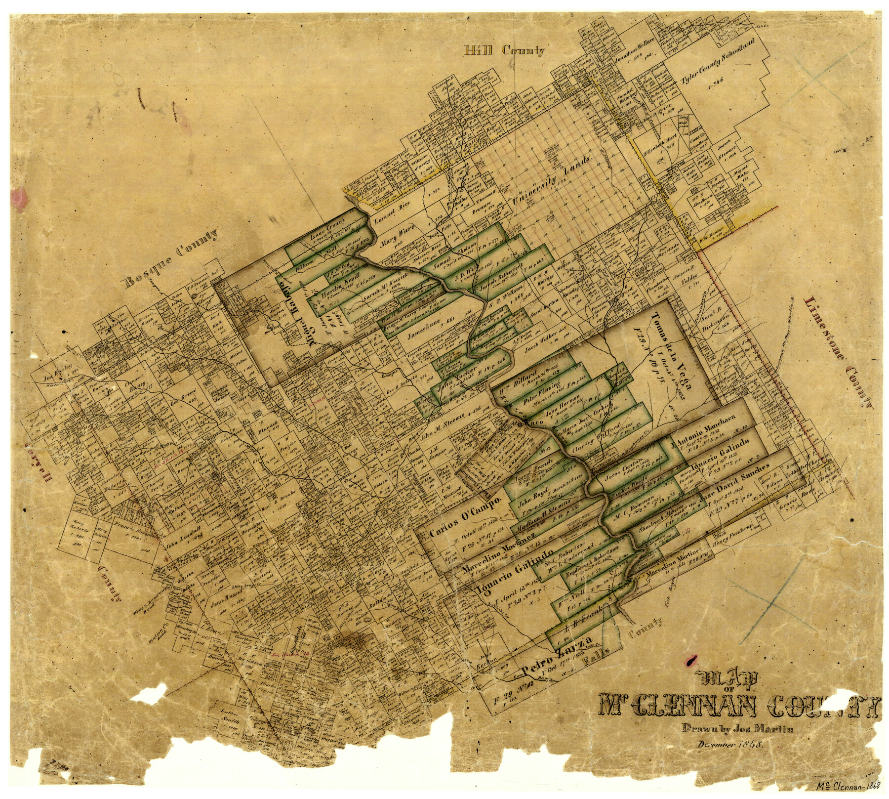
Map of McClennan County
-
Map/Doc
3861
-
Collection
General Map Collection
-
Object Dates
12/1868 (Creation Date)
-
People and Organizations
Texas General Land Office (Publisher)
Joseph Martin (Draftsman)
-
Counties
McLennan
-
Subjects
County
-
Height x Width
22.8 x 25.4 inches
57.9 x 64.5 cm
-
Features
Wasp Creek
Upper Road from Waco to Gatesville
Gatesville Road
Bluff Creek
South Bosque River
Brazos River
Waco
Waco Creek
Lower Waco Creek
Tradinghouse Creek
Cave Creek
Flat Creek
South Branch [of South Bosque River]
Harris Creek
Tank Creek
Middle Bosque River
Waco to Lampasas Road
Lampasas Road
Station Creek Road
Sheep Range Creek
Perry and Waco Road
Perry Road
Hahby's Hill
Wouth Fork of Cow Bayou
Bullhide Creek
Bear Creek
Lake Creek
Fish Bayou
Turtle Bayou
South Fork [of Cow Bayou]
Hamilton Road
East Fork of Tahuacano Creek
Ash Creek
Russel Branch [of Tehuacano Creek]
Cottonwood Branch [of Tehuacano Creek]
Aquilla Creek
Waco and Fort Graham Road
Waco Road
Fort Graham Road
Childress Creek
Waco and Clifton Road
Clifton Road
Hogg Creek
Live Oak Creek
Waco and Hamilton Road
Elingtons Creek
Searsville and Clifton Road
Searsville Road
Bosque River
Horse Bluff
Otter Creek
Campbell's Creek
Elm Fork [of Tehuacano Creek]
Aguila Creek
Tehuacano Creek
Hillsborough, Dallas and Martin Road
Hillsborough Road
Dallas Road
Martin Road
Raineys Creek
Part of: General Map Collection
[Sketch of Col. Cooke's Military Road expedition from Red River to Austin]
![166, [Sketch of Col. Cooke's Military Road expedition from Red River to Austin], General Map Collection](https://historictexasmaps.com/wmedia_w700/maps/166.tif.jpg)
Print $20.00
- Digital $50.00
[Sketch of Col. Cooke's Military Road expedition from Red River to Austin]
Size 29.4 x 22.9 inches
Map/Doc 166

Map of Henderson County

Print $20.00
- Digital $50.00
Map of Henderson County
1871
Size 16.3 x 30.3 inches
Map/Doc 4563
Flight Mission No. CUG-3P, Frame 20, Kleberg County

Print $20.00
- Digital $50.00
Flight Mission No. CUG-3P, Frame 20, Kleberg County
1956
Size 18.4 x 22.3 inches
Map/Doc 86230
Montgomery County Rolled Sketch 19A

Print $40.00
- Digital $50.00
Montgomery County Rolled Sketch 19A
1933
Size 53.4 x 35.4 inches
Map/Doc 9530
Tom Green County Sketch File 60

Print $20.00
- Digital $50.00
Tom Green County Sketch File 60
1888
Size 28.4 x 25.9 inches
Map/Doc 12444
Map of Brazoria County

Print $20.00
- Digital $50.00
Map of Brazoria County
1883
Size 26.8 x 25.6 inches
Map/Doc 861

Jeff Davis County Working Sketch 19

Print $40.00
- Digital $50.00
Jeff Davis County Working Sketch 19
1957
Size 71.3 x 34.1 inches
Map/Doc 66514
Clay County Rolled Sketch 4A

Print $20.00
- Digital $50.00
Clay County Rolled Sketch 4A
1949
Size 22.0 x 24.0 inches
Map/Doc 5498
Mineral Plats - El Paso to Ward Co. and River Beds

Mineral Plats - El Paso to Ward Co. and River Beds
Map/Doc 81746
Map of Texas from the most recent authorities

Print $20.00
- Digital $50.00
Map of Texas from the most recent authorities
1845
Map/Doc 93945
You may also like
Potter County Working Sketch 14

Print $20.00
- Digital $50.00
Potter County Working Sketch 14
1982
Size 33.7 x 32.6 inches
Map/Doc 71674
A new and accurate map of North America (wherein the errors of all preceeding British, French and Dutch maps, respecting the rights of Great Britain, France & Spain, & the limits of each of His Majesty's provinces, are corrected)

Print $20.00
- Digital $50.00
A new and accurate map of North America (wherein the errors of all preceeding British, French and Dutch maps, respecting the rights of Great Britain, France & Spain, & the limits of each of His Majesty's provinces, are corrected)
1755
Size 18.3 x 22.1 inches
Map/Doc 97416
Layout of the porciones as described in the Visita General of Camargo, 1767

Layout of the porciones as described in the Visita General of Camargo, 1767
2009
Size 11.0 x 8.5 inches
Map/Doc 94041
[T. & P. RR. Co. Blocks 54, 55 and 76, Townships 1 and 2]
![89888, [T. & P. RR. Co. Blocks 54, 55 and 76, Townships 1 and 2], Twichell Survey Records](https://historictexasmaps.com/wmedia_w700/maps/89888-1.tif.jpg)
Print $20.00
- Digital $50.00
[T. & P. RR. Co. Blocks 54, 55 and 76, Townships 1 and 2]
Size 44.2 x 36.2 inches
Map/Doc 89888
Nueces County Rolled Sketch 100

Print $20.00
- Digital $50.00
Nueces County Rolled Sketch 100
Size 21.3 x 32.7 inches
Map/Doc 10697

Blanco County Sketch File 37

Print $4.00
- Digital $50.00
Blanco County Sketch File 37
Size 8.7 x 14.1 inches
Map/Doc 14646
General Highway Map, Henderson County, Texas

Print $20.00
General Highway Map, Henderson County, Texas
1961
Size 24.9 x 18.0 inches
Map/Doc 79517
Brewster County Rolled Sketch 20

Print $20.00
- Digital $50.00
Brewster County Rolled Sketch 20
Size 31.4 x 28.2 inches
Map/Doc 5199
Dallas County Working Sketch 12

Print $20.00
- Digital $50.00
Dallas County Working Sketch 12
1983
Size 30.5 x 44.1 inches
Map/Doc 68578
Coleman County Sketch File 43

Print $12.00
- Digital $50.00
Coleman County Sketch File 43
1892
Size 9.2 x 8.8 inches
Map/Doc 18775
El Paso County Working Sketch 30

Print $40.00
- Digital $50.00
El Paso County Working Sketch 30
1967
Size 32.0 x 65.8 inches
Map/Doc 69052