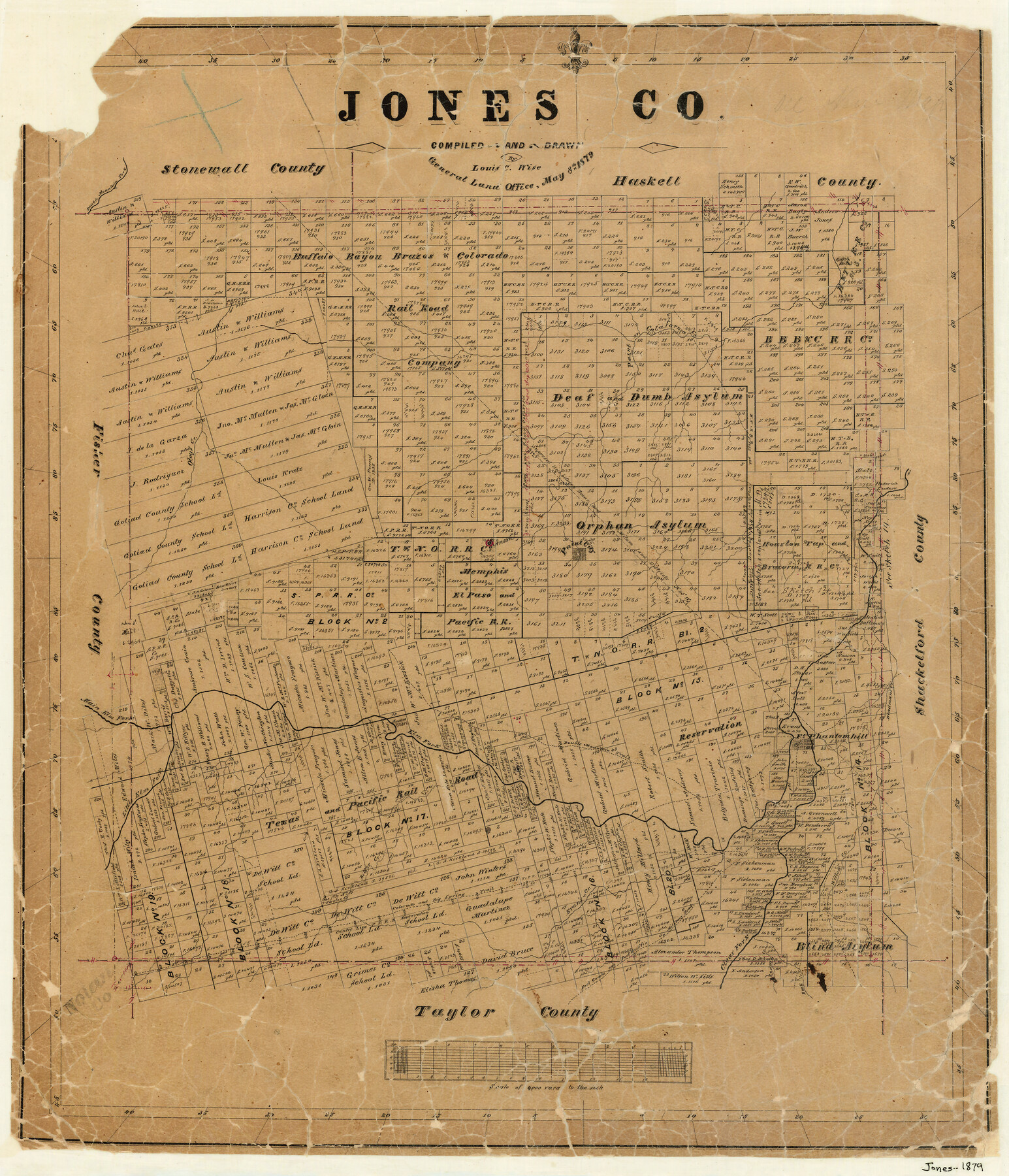
Jones County
-
Map/Doc
3740
-
Collection
General Map Collection
-
Object Dates
5/8/1879 (Creation Date)
-
People and Organizations
Louis C. Wise (Draftsman)
-
Counties
Jones
-
Subjects
County
-
Height x Width
22.5 x 19.7 inches
57.2 x 50.0 cm
-
Features
Colorado and Big Spring Trail
Rainey Creek
Buck Creek
Willow Creek
Clear Fork
Fort Griffin Military Road
Fort Concho Military Road
Fort Concho and Fort Griffin Military Road
Ritter Creek
Little Elm Fork
Bitter Creek
Big Spring Trail
Colorado Trail
Double Mountain Fork
Evan's Creek
Deadman's Creek
Fort Phantom Hill
Fort Phantomhill [sic]
Double Mountain Trail
Elm Fork
Main Elm Fork
Otey's Creek
Anson
Paint City
Calafornia [sic] Creek
Paint Creek
Part of: General Map Collection
Upton County Working Sketch 59

Print $20.00
- Digital $50.00
Upton County Working Sketch 59
1987
Size 21.5 x 34.3 inches
Map/Doc 69556
Brazoria County Working Sketch 3

Print $20.00
- Digital $50.00
Brazoria County Working Sketch 3
1915
Size 13.0 x 11.1 inches
Map/Doc 67488
Texas State Boundary Line 7

Print $182.00
Texas State Boundary Line 7
2000
Size 11.2 x 8.8 inches
Map/Doc 75018
Mills County Working Sketch 17

Print $20.00
- Digital $50.00
Mills County Working Sketch 17
1963
Size 20.4 x 17.9 inches
Map/Doc 71047
Lavaca County Working Sketch 11

Print $20.00
- Digital $50.00
Lavaca County Working Sketch 11
1954
Size 34.0 x 28.3 inches
Map/Doc 70364
Jones County Sketch File 5

Print $4.00
- Digital $50.00
Jones County Sketch File 5
1859
Size 10.0 x 8.1 inches
Map/Doc 28492
Potter County Rolled Sketch 13

Print $20.00
- Digital $50.00
Potter County Rolled Sketch 13
2004
Size 18.4 x 23.4 inches
Map/Doc 82476
Gregg County Sketch File 1G

Print $2.00
- Digital $50.00
Gregg County Sketch File 1G
Size 6.2 x 7.0 inches
Map/Doc 24549
Lynn County Rolled Sketch 14

Print $20.00
- Digital $50.00
Lynn County Rolled Sketch 14
1952
Size 35.4 x 35.3 inches
Map/Doc 9474
Sulphur River, Boxelder Sheet/Cuthand Creek

Print $20.00
- Digital $50.00
Sulphur River, Boxelder Sheet/Cuthand Creek
1922
Size 29.5 x 25.1 inches
Map/Doc 65156
Calhoun County NRC Article 33.136 Sketch 12

Print $24.00
Calhoun County NRC Article 33.136 Sketch 12
2023
Map/Doc 97271
Colorado River, Wharton to Bay City Sheet 1, Texas

Print $40.00
- Digital $50.00
Colorado River, Wharton to Bay City Sheet 1, Texas
1924
Size 73.9 x 38.9 inches
Map/Doc 65262
You may also like
Midland County Rolled Sketch 1

Print $20.00
- Digital $50.00
Midland County Rolled Sketch 1
1940
Size 32.9 x 35.0 inches
Map/Doc 9512
Jefferson County Working Sketch 5

Print $20.00
- Digital $50.00
Jefferson County Working Sketch 5
1930
Size 32.7 x 21.8 inches
Map/Doc 66548
Angelina County Working Sketch 44

Print $20.00
- Digital $50.00
Angelina County Working Sketch 44
1976
Size 22.2 x 25.7 inches
Map/Doc 67127
Old Miscellaneous File 8

Print $15.00
- Digital $50.00
Old Miscellaneous File 8
1853
Size 16.7 x 10.5 inches
Map/Doc 75427
Montgomery County Rolled Sketch 12

Print $20.00
- Digital $50.00
Montgomery County Rolled Sketch 12
Size 23.4 x 30.5 inches
Map/Doc 6801
Index for Texas Railroad ROW & track maps available on microfilm at THD & Archives and Records

Print $2.00
- Digital $50.00
Index for Texas Railroad ROW & track maps available on microfilm at THD & Archives and Records
1977
Size 11.2 x 8.8 inches
Map/Doc 60757
The Coast of New Spain from Neuva Vera Cruz to Triste Island

Print $20.00
- Digital $50.00
The Coast of New Spain from Neuva Vera Cruz to Triste Island
Size 21.0 x 28.9 inches
Map/Doc 95919
C. C. S. D. & R. G. N. G. RR. Company, Block C2]
![90780, C. C. S. D. & R. G. N. G. RR. Company, Block C2], Twichell Survey Records](https://historictexasmaps.com/wmedia_w700/maps/90780-1.tif.jpg)
Print $20.00
- Digital $50.00
C. C. S. D. & R. G. N. G. RR. Company, Block C2]
Size 14.0 x 21.2 inches
Map/Doc 90780
Jasper County Working Sketch 11

Print $20.00
- Digital $50.00
Jasper County Working Sketch 11
1917
Size 20.2 x 23.4 inches
Map/Doc 66473
Map of the Territory of the United States from the Mississippi to the Pacific Ocean ordered by the Hon. Jeff'n Davis, Secretary of War to accompany the reports of the explorations for a railroad route

Print $40.00
- Digital $50.00
Map of the Territory of the United States from the Mississippi to the Pacific Ocean ordered by the Hon. Jeff'n Davis, Secretary of War to accompany the reports of the explorations for a railroad route
Size 48.6 x 50.7 inches
Map/Doc 94276
Flight Mission No. BRE-1P, Frame 58, Nueces County

Print $20.00
- Digital $50.00
Flight Mission No. BRE-1P, Frame 58, Nueces County
1956
Size 18.5 x 22.2 inches
Map/Doc 86647
Wood County Boundary File 4

Print $6.00
- Digital $50.00
Wood County Boundary File 4
Size 12.1 x 8.1 inches
Map/Doc 60167