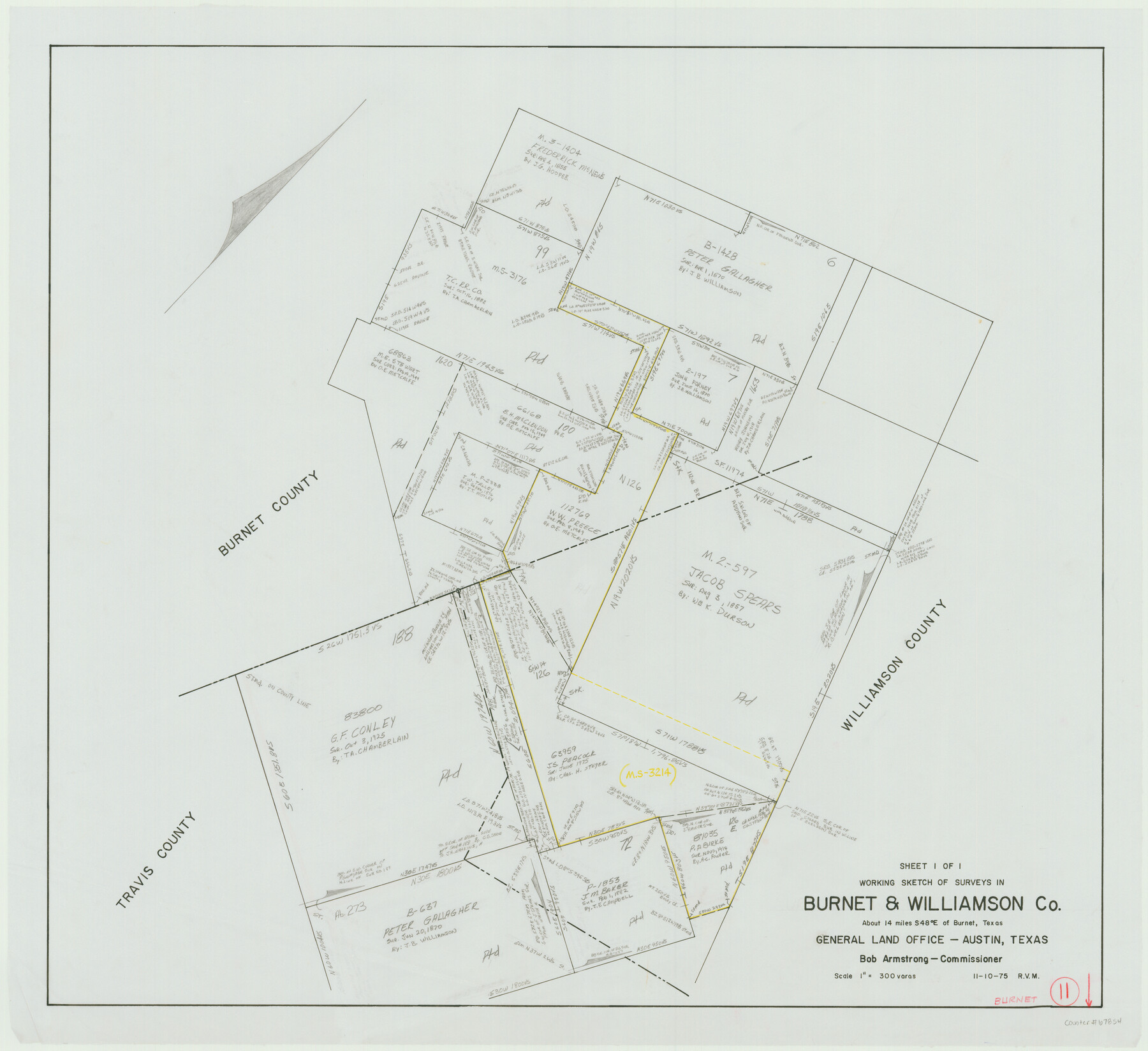
Burnet County Working Sketch 11
-
Map/Doc
67854
-
Collection
General Map Collection
-
Object Dates
11/10/1975 (Creation Date)
-
People and Organizations
Rosendo V. Molina (Draftsman)
-
Counties
Burnet Williamson
-
Subjects
Surveying Working Sketch
-
Height x Width
26.5 x 28.9 inches
67.3 x 73.4 cm
-
Scale
1" = 300 varas
Part of: General Map Collection
Winkler County Rolled Sketch 10

Print $40.00
- Digital $50.00
Winkler County Rolled Sketch 10
1958
Size 29.4 x 55.9 inches
Map/Doc 10151
Newton County Sketch File 7

Print $4.00
- Digital $50.00
Newton County Sketch File 7
1872
Size 6.1 x 8.3 inches
Map/Doc 32374
Hutchinson County Rolled Sketch 44-15

Print $20.00
- Digital $50.00
Hutchinson County Rolled Sketch 44-15
2002
Size 24.0 x 36.0 inches
Map/Doc 77551
Flight Mission No. CRC-3R, Frame 47, Chambers County

Print $20.00
- Digital $50.00
Flight Mission No. CRC-3R, Frame 47, Chambers County
1956
Size 18.6 x 22.3 inches
Map/Doc 84820
Flight Mission No. BRA-16M, Frame 116, Jefferson County

Print $20.00
- Digital $50.00
Flight Mission No. BRA-16M, Frame 116, Jefferson County
1953
Size 18.5 x 22.3 inches
Map/Doc 85726
Denton County Sketch File 1

Print $2.00
- Digital $50.00
Denton County Sketch File 1
Size 8.4 x 10.6 inches
Map/Doc 20681
Andrews County Working Sketch 3

Print $40.00
- Digital $50.00
Andrews County Working Sketch 3
1953
Size 78.9 x 35.8 inches
Map/Doc 67049
Field Notes for the Remonumentation of the Northwest Corner of the State of Texas by the Department of the Interior

Print $38.00
Field Notes for the Remonumentation of the Northwest Corner of the State of Texas by the Department of the Interior
1991
Map/Doc 81687
Flight Mission No. DCL-6C, Frame 4, Kenedy County

Print $20.00
- Digital $50.00
Flight Mission No. DCL-6C, Frame 4, Kenedy County
1943
Size 18.7 x 22.3 inches
Map/Doc 85864
Ochiltree County

Print $20.00
- Digital $50.00
Ochiltree County
1958
Size 43.4 x 34.4 inches
Map/Doc 73253
Trinity River, Irving Sheet

Print $4.00
- Digital $50.00
Trinity River, Irving Sheet
1925
Size 20.7 x 17.9 inches
Map/Doc 65212
Floyd County Boundary File 4b

Print $40.00
- Digital $50.00
Floyd County Boundary File 4b
Size 11.9 x 24.8 inches
Map/Doc 53498
You may also like
Wheeler County Working Sketch 19

Print $20.00
- Digital $50.00
Wheeler County Working Sketch 19
1986
Size 33.5 x 31.8 inches
Map/Doc 72508
Sec. 22, Block 103

Print $20.00
- Digital $50.00
Sec. 22, Block 103
Size 13.1 x 14.8 inches
Map/Doc 90120
Ralls, Crosby County, Texas

Print $20.00
- Digital $50.00
Ralls, Crosby County, Texas
Size 22.5 x 29.8 inches
Map/Doc 92601
Zavala County Sketch File 45

Print $4.00
- Digital $50.00
Zavala County Sketch File 45
1923
Size 11.5 x 8.8 inches
Map/Doc 41428
Flight Mission No. CLL-1N, Frame 33, Willacy County

Print $20.00
- Digital $50.00
Flight Mission No. CLL-1N, Frame 33, Willacy County
1954
Size 18.4 x 22.1 inches
Map/Doc 87014
Runnels County Rolled Sketch 47

Print $40.00
- Digital $50.00
Runnels County Rolled Sketch 47
1954
Size 49.9 x 30.5 inches
Map/Doc 76167
Stonewall County Working Sketch 22

Print $20.00
- Digital $50.00
Stonewall County Working Sketch 22
1966
Size 44.2 x 32.9 inches
Map/Doc 62329
Engineer's Office, Department of the Gulf Map No. 59, Texas prepared by order of Maj. Gen. N. P. Banks under direction of Capt. P. C. Hains, U. S. Engr. & Chief Engr., Dept. of the Gulf

Print $20.00
- Digital $50.00
Engineer's Office, Department of the Gulf Map No. 59, Texas prepared by order of Maj. Gen. N. P. Banks under direction of Capt. P. C. Hains, U. S. Engr. & Chief Engr., Dept. of the Gulf
1865
Size 18.3 x 27.6 inches
Map/Doc 72717
Knox County Working Sketch 3

Print $20.00
- Digital $50.00
Knox County Working Sketch 3
1917
Size 25.0 x 17.0 inches
Map/Doc 70245
San Patricio County Working Sketch 5

Print $20.00
- Digital $50.00
San Patricio County Working Sketch 5
1934
Size 31.6 x 35.9 inches
Map/Doc 63767
Colorado County Working Sketch 18

Print $20.00
- Digital $50.00
Colorado County Working Sketch 18
1957
Size 31.2 x 37.3 inches
Map/Doc 68118
Galveston County Sketch File 9

Print $6.00
- Digital $50.00
Galveston County Sketch File 9
1866
Size 10.1 x 8.1 inches
Map/Doc 23369