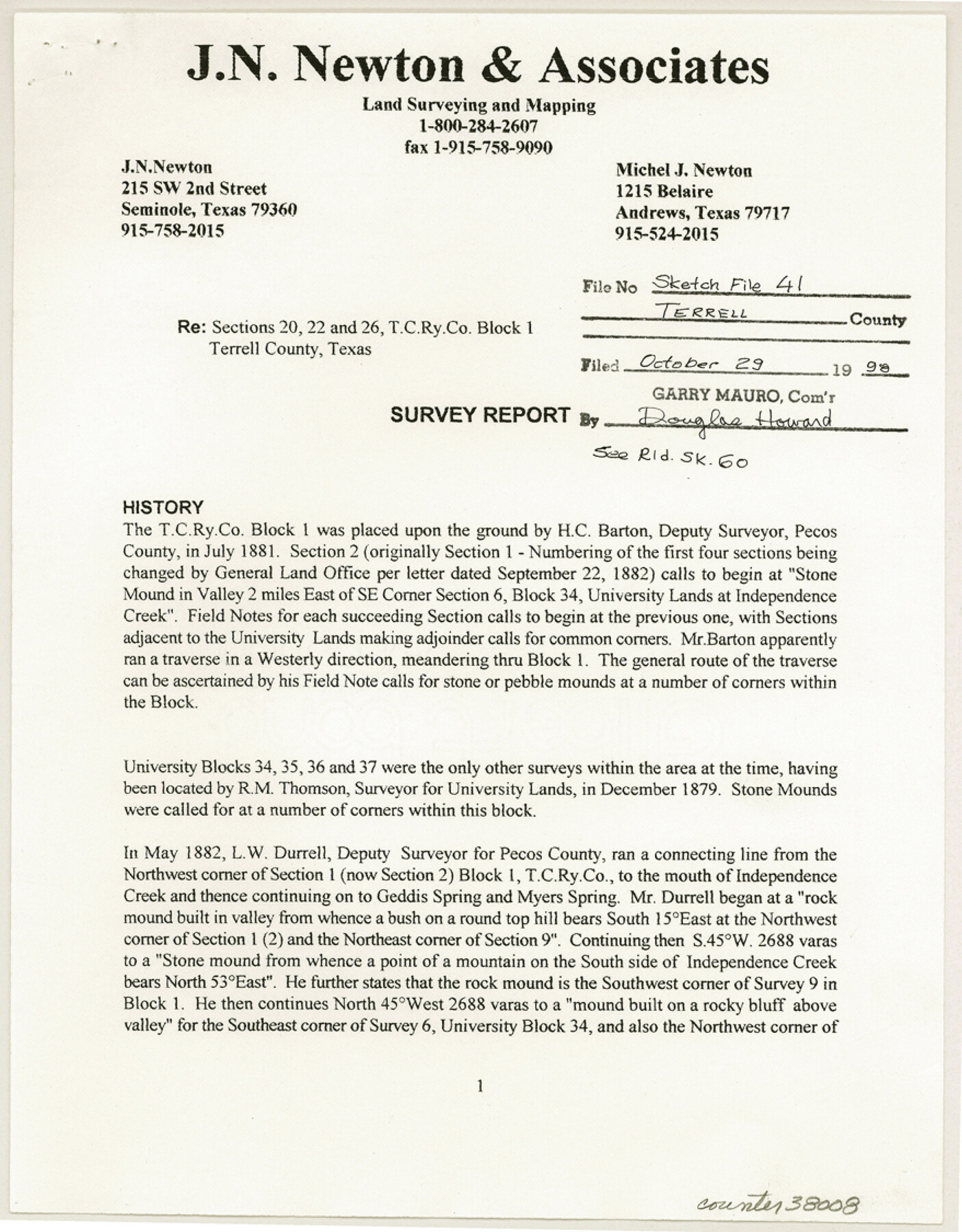
Terrell County Sketch File 41
[Survey report regarding sections 20, 22, and 26, T. C. Ry. Co. Block 1]
-
Map/Doc
38008
-
Collection
General Map Collection
-
Object Dates
10/29/1998 (File Date)
-
People and Organizations
J.N. Newton (Surveyor/Engineer)
-
Counties
Terrell
-
Subjects
Surveying Sketch File
-
Height x Width
11.3 x 8.8 inches
28.7 x 22.4 cm
-
Medium
paper, print
-
Comments
See Terrell County Rolled Sketch 60 (7976) for related sketch.
-
Features
Independence Creek
Geddis Spring
Myers Spring
Mitchell Ranch
Corder Ranch
Related maps
Terrell County Rolled Sketch 60

Print $20.00
- Digital $50.00
Terrell County Rolled Sketch 60
1998
Size 13.2 x 38.1 inches
Map/Doc 7976
Part of: General Map Collection
Colorado River, Hungerford Sheet

Print $6.00
- Digital $50.00
Colorado River, Hungerford Sheet
1941
Size 24.1 x 35.4 inches
Map/Doc 65309
Wilson County Sketch File 10

Print $4.00
- Digital $50.00
Wilson County Sketch File 10
Size 6.7 x 6.2 inches
Map/Doc 40417
Galveston County NRC Article 33.136 Sketch 67

Print $28.00
- Digital $50.00
Galveston County NRC Article 33.136 Sketch 67
2011
Size 17.0 x 24.0 inches
Map/Doc 93391
Colton's New Map of the State of Texas Compiled from J. De Cordova's large Map

Print $20.00
- Digital $50.00
Colton's New Map of the State of Texas Compiled from J. De Cordova's large Map
1859
Size 17.9 x 28.3 inches
Map/Doc 90094
Rusk County Sketch File 17

Print $22.00
Rusk County Sketch File 17
1857
Size 12.7 x 15.7 inches
Map/Doc 35520
Jeff Davis County Boundary File 2a

Print $40.00
- Digital $50.00
Jeff Davis County Boundary File 2a
Size 11.1 x 36.7 inches
Map/Doc 55512
Liberty County Working Sketch 91b

Print $40.00
- Digital $50.00
Liberty County Working Sketch 91b
1919
Size 48.7 x 42.1 inches
Map/Doc 65458
Dimmit County Rolled Sketch 20A

Print $20.00
- Digital $50.00
Dimmit County Rolled Sketch 20A
1999
Size 24.9 x 36.5 inches
Map/Doc 6065
Reagan County Rolled Sketch 15

Print $20.00
- Digital $50.00
Reagan County Rolled Sketch 15
Size 16.7 x 22.7 inches
Map/Doc 7443
Moore County Working Sketch 8

Print $20.00
- Digital $50.00
Moore County Working Sketch 8
1948
Size 23.2 x 31.8 inches
Map/Doc 71190
Presidio County Rolled Sketch 131B

Print $20.00
- Digital $50.00
Presidio County Rolled Sketch 131B
1993
Size 33.4 x 46.7 inches
Map/Doc 9803
Terrell County Rolled Sketch 53A

Print $20.00
- Digital $50.00
Terrell County Rolled Sketch 53A
Size 32.9 x 24.2 inches
Map/Doc 7972
You may also like
Harris County Working Sketch 20

Print $20.00
- Digital $50.00
Harris County Working Sketch 20
1923
Size 11.7 x 12.4 inches
Map/Doc 65912
Webb County Working Sketch 54

Print $20.00
- Digital $50.00
Webb County Working Sketch 54
1954
Size 43.1 x 33.6 inches
Map/Doc 72420
![90591, [Block K7], Twichell Survey Records](https://historictexasmaps.com/wmedia_w700/maps/90591-1.tif.jpg)
Uvalde County Working Sketch 27

Print $20.00
- Digital $50.00
Uvalde County Working Sketch 27
1957
Size 24.4 x 25.7 inches
Map/Doc 72097
Galveston County Sketch File 31

Print $20.00
- Digital $50.00
Galveston County Sketch File 31
1916
Size 23.7 x 13.6 inches
Map/Doc 11534
Trinity River, Hutchins Bridge Sheet

Print $20.00
- Digital $50.00
Trinity River, Hutchins Bridge Sheet
1922
Size 38.6 x 33.2 inches
Map/Doc 65190
Official Map of the City of Waxahachie, Texas
.tif.jpg)
Print $20.00
- Digital $50.00
Official Map of the City of Waxahachie, Texas
1922
Size 41.4 x 40.8 inches
Map/Doc 4841
Mitchell County Boundary File 66a

Print $11.00
- Digital $50.00
Mitchell County Boundary File 66a
Size 12.6 x 8.3 inches
Map/Doc 57378
[Unidentified Railroad through Denton and Dallas County]
![64775, [Unidentified Railroad through Denton and Dallas County], General Map Collection](https://historictexasmaps.com/wmedia_w700/maps/64775.tif.jpg)
Print $40.00
- Digital $50.00
[Unidentified Railroad through Denton and Dallas County]
Size 6.8 x 73.3 inches
Map/Doc 64775
San Jacinto County Sketch File 12a

Print $20.00
San Jacinto County Sketch File 12a
Size 12.8 x 14.3 inches
Map/Doc 35722
Jefferson County Sketch File 5b

Print $6.00
- Digital $50.00
Jefferson County Sketch File 5b
1860
Size 9.3 x 11.1 inches
Map/Doc 28108
Coast Chart No. 210 Aransas Pass and Corpus Christi Bay with the coast to latitude 27° 12' Texas

Print $20.00
- Digital $50.00
Coast Chart No. 210 Aransas Pass and Corpus Christi Bay with the coast to latitude 27° 12' Texas
1913
Size 27.7 x 18.3 inches
Map/Doc 72798