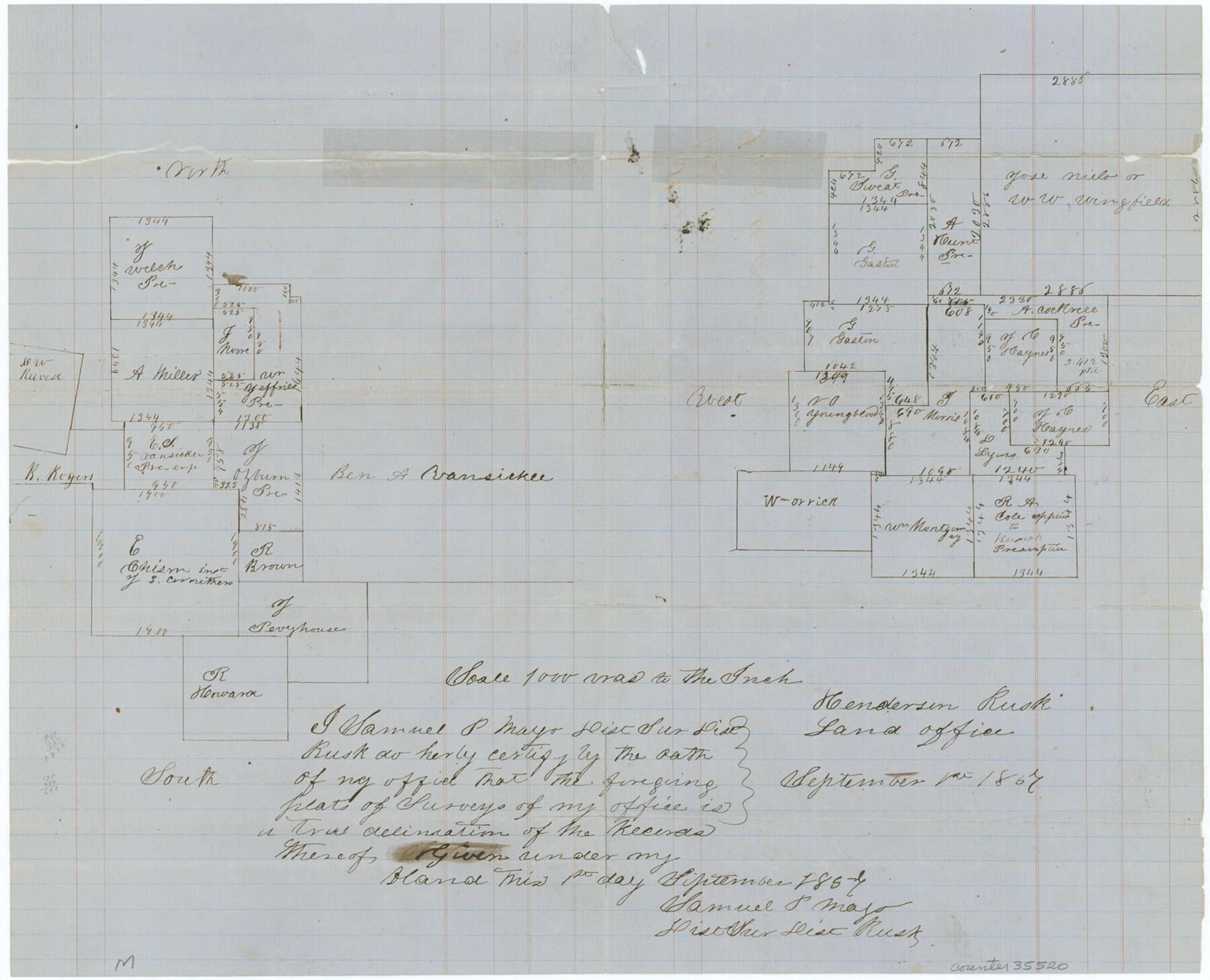
Rusk County Sketch File 17
[Two sketches of surveys located southeast of Henderson]
-
Map/Doc
35520
-
Collection
General Map Collection
-
Object Dates
9/1/1857 (Creation Date)
10/5/1857 (File Date)
-
People and Organizations
Samuel P. Mayo (Surveyor/Engineer)
-
Counties
Rusk
-
Subjects
Surveying Sketch File
-
Height x Width
12.7 x 15.7 inches
32.3 x 39.9 cm
-
Medium
paper, manuscript
-
Scale
1" = 1000 varas
Part of: General Map Collection
Motley County Sketch File 18 (N)

Print $4.00
- Digital $50.00
Motley County Sketch File 18 (N)
1913
Size 11.3 x 8.7 inches
Map/Doc 32062
Map of Hopkins County

Print $20.00
- Digital $50.00
Map of Hopkins County
1863
Size 22.6 x 24.1 inches
Map/Doc 3679
General Land Office and State Reclamation Department - An Index Map

Print $20.00
- Digital $50.00
General Land Office and State Reclamation Department - An Index Map
1930
Size 25.8 x 16.4 inches
Map/Doc 3027
Flight Mission No. BQR-7K, Frame 24, Brazoria County

Print $20.00
- Digital $50.00
Flight Mission No. BQR-7K, Frame 24, Brazoria County
1952
Size 18.6 x 22.2 inches
Map/Doc 84022
Kleberg County Rolled Sketch 5A

Print $20.00
- Digital $50.00
Kleberg County Rolled Sketch 5A
Size 31.0 x 25.1 inches
Map/Doc 6549
Jones County Sketch File 10a

Print $40.00
- Digital $50.00
Jones County Sketch File 10a
1875
Size 40.0 x 50.6 inches
Map/Doc 10509
Sketch Showing Land Ties with Houston & Texas Central Railroad Through Harris County, Texas

Print $20.00
- Digital $50.00
Sketch Showing Land Ties with Houston & Texas Central Railroad Through Harris County, Texas
1880
Size 7.3 x 27.0 inches
Map/Doc 66739
Cochran County Rolled Sketch 6

Print $20.00
- Digital $50.00
Cochran County Rolled Sketch 6
2025
Size 20.5 x 28.2 inches
Map/Doc 97417
Carson County Working Sketch 2

Print $3.00
- Digital $50.00
Carson County Working Sketch 2
1907
Size 16.7 x 10.0 inches
Map/Doc 67873
Sutton County Working Sketch 60

Print $20.00
- Digital $50.00
Sutton County Working Sketch 60
1959
Size 29.1 x 34.6 inches
Map/Doc 62403
Kimble County Rolled Sketch 29

Print $20.00
- Digital $50.00
Kimble County Rolled Sketch 29
Size 27.5 x 31.0 inches
Map/Doc 6519
Kerr County Rolled Sketch 12

Print $20.00
- Digital $50.00
Kerr County Rolled Sketch 12
1951
Size 22.6 x 28.5 inches
Map/Doc 6497
You may also like
Menard County Working Sketch 24

Print $20.00
- Digital $50.00
Menard County Working Sketch 24
1950
Size 38.1 x 22.6 inches
Map/Doc 70971
Map of Hardin County

Print $20.00
- Digital $50.00
Map of Hardin County
1902
Size 40.8 x 43.9 inches
Map/Doc 4971
Sur. Sketch S. F. 6855

Print $20.00
- Digital $50.00
Sur. Sketch S. F. 6855
Size 20.2 x 10.2 inches
Map/Doc 90788
Lampasas County Working Sketch 17

Print $20.00
- Digital $50.00
Lampasas County Working Sketch 17
1977
Size 24.0 x 13.2 inches
Map/Doc 70294
Newton County Working Sketch 34

Print $20.00
- Digital $50.00
Newton County Working Sketch 34
1959
Size 27.0 x 32.6 inches
Map/Doc 71280
Maps & Lists Showing Prison Lands (Oil & Gas) Leased as of June 1955

Digital $50.00
Maps & Lists Showing Prison Lands (Oil & Gas) Leased as of June 1955
1934
Size 29.6 x 38.1 inches
Map/Doc 62880
Upshur County Sketch File 5

Print $4.00
- Digital $50.00
Upshur County Sketch File 5
1855
Size 8.3 x 12.9 inches
Map/Doc 38740
Sabine River, Gladewater Sheet

Print $20.00
- Digital $50.00
Sabine River, Gladewater Sheet
1933
Size 38.5 x 30.9 inches
Map/Doc 65138
Baylor County Working Sketch 2

Print $20.00
- Digital $50.00
Baylor County Working Sketch 2
1919
Size 22.4 x 24.1 inches
Map/Doc 67287
Montague County Working Sketch 6

Print $20.00
- Digital $50.00
Montague County Working Sketch 6
1923
Size 16.9 x 27.2 inches
Map/Doc 71072
Jeff Davis County Rolled Sketch 6A

Print $20.00
- Digital $50.00
Jeff Davis County Rolled Sketch 6A
1889
Size 20.1 x 40.4 inches
Map/Doc 6361
Tarrant County Rolled Sketch 4

Print $20.00
- Digital $50.00
Tarrant County Rolled Sketch 4
1982
Size 27.2 x 19.2 inches
Map/Doc 7912