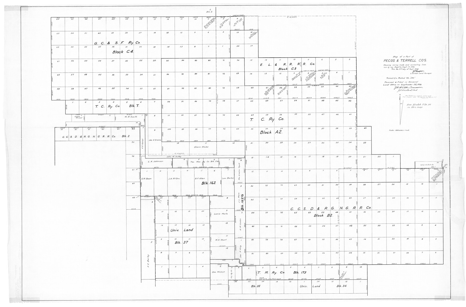
Terrell County Rolled Sketch JAS
Map of a part of Pecos & Terrell Cos. showing survey made and connecting lines run
-
Map/Doc
9988
-
Collection
General Map Collection
-
Object Dates
1936/9/21 (Creation Date)
1936/9/22 (File Date)
-
People and Organizations
J.A. Simpson (Surveyor/Engineer)
-
Counties
Terrell Pecos
-
Subjects
Surveying Rolled Sketch
-
Height x Width
48.5 x 40.0 inches
123.2 x 101.6 cm
-
Scale
1" = 1000 varas
-
Comments
See Terrell County Sketch File 27 (37971) for traverse sheets, and see Terrell County Sketch File 34 (37984) and Pecos County Sketch File 102 (34014) for correspondence and memo.
Related maps
Pecos County Sketch File 102

Print $4.00
- Digital $50.00
Pecos County Sketch File 102
Size 9.9 x 4.4 inches
Map/Doc 34014
Terrell County Sketch File 27

Print $10.00
- Digital $50.00
Terrell County Sketch File 27
1936
Size 8.7 x 11.3 inches
Map/Doc 37971
Terrell County Sketch File 34

Print $12.00
- Digital $50.00
Terrell County Sketch File 34
1960
Size 9.7 x 8.5 inches
Map/Doc 37984
Part of: General Map Collection
Aransas County Sketch File B

Print $4.00
- Digital $50.00
Aransas County Sketch File B
Size 6.9 x 11.4 inches
Map/Doc 13216
Somervell County Rolled Sketch B

Print $20.00
- Digital $50.00
Somervell County Rolled Sketch B
Size 18.8 x 19.9 inches
Map/Doc 7792
Waller County Sketch File 2

Print $52.00
- Digital $50.00
Waller County Sketch File 2
Size 13.3 x 9.0 inches
Map/Doc 39570
Parker County Sketch File 23

Print $20.00
- Digital $50.00
Parker County Sketch File 23
1876
Size 18.8 x 22.8 inches
Map/Doc 12145
Hardin County Rolled Sketch 12

Print $20.00
- Digital $50.00
Hardin County Rolled Sketch 12
1949
Size 36.3 x 47.3 inches
Map/Doc 10200
No. 1 - Survey for a road from the Brazo Santiago to the Rio Grande

Print $20.00
- Digital $50.00
No. 1 - Survey for a road from the Brazo Santiago to the Rio Grande
1847
Size 18.3 x 27.2 inches
Map/Doc 72878
Erath County Sketch File 33

Print $11.00
- Digital $50.00
Erath County Sketch File 33
1962
Size 14.4 x 8.8 inches
Map/Doc 22315
[Surveys along the San Marcos River]
![152, [Surveys along the San Marcos River], General Map Collection](https://historictexasmaps.com/wmedia_w700/maps/152.tif.jpg)
Print $2.00
- Digital $50.00
[Surveys along the San Marcos River]
Size 9.6 x 8.0 inches
Map/Doc 152
Carson County Boundary File 4

Print $4.00
- Digital $50.00
Carson County Boundary File 4
Size 9.6 x 6.2 inches
Map/Doc 51132
Fannin County

Print $20.00
- Digital $50.00
Fannin County
1946
Size 40.6 x 35.4 inches
Map/Doc 77277
Pecos County Working Sketch 95

Print $20.00
- Digital $50.00
Pecos County Working Sketch 95
1970
Size 42.6 x 40.6 inches
Map/Doc 71568
Galveston County Rolled Sketch 47

Print $20.00
- Digital $50.00
Galveston County Rolled Sketch 47
1999
Size 24.6 x 36.7 inches
Map/Doc 77534
You may also like
Brazos Santiago, Texas

Print $20.00
- Digital $50.00
Brazos Santiago, Texas
1900
Size 18.2 x 27.1 inches
Map/Doc 73034
Angelina County Working Sketch 53

Print $40.00
- Digital $50.00
Angelina County Working Sketch 53
1988
Size 42.9 x 58.5 inches
Map/Doc 67137
Atascosa County Sketch File 16a

Print $4.00
- Digital $50.00
Atascosa County Sketch File 16a
1878
Size 12.7 x 8.2 inches
Map/Doc 13781
Kinney County Working Sketch 54

Print $20.00
- Digital $50.00
Kinney County Working Sketch 54
1981
Size 40.0 x 32.8 inches
Map/Doc 70236
Hutchinson County Sketch File 42

Print $9.00
- Digital $50.00
Hutchinson County Sketch File 42
1920
Size 14.3 x 8.9 inches
Map/Doc 27305
[Sketch for Mineral Application 1112 - Colorado River, H. E. Chambers]
![65639, [Sketch for Mineral Application 1112 - Colorado River, H. E. Chambers], General Map Collection](https://historictexasmaps.com/wmedia_w700/maps/65639.tif.jpg)
Print $20.00
- Digital $50.00
[Sketch for Mineral Application 1112 - Colorado River, H. E. Chambers]
1918
Size 17.3 x 28.3 inches
Map/Doc 65639
Sutton County Sketch File 59

Print $20.00
- Digital $50.00
Sutton County Sketch File 59
Size 24.6 x 16.5 inches
Map/Doc 12394
Topographical Map of the Rio Grande from Roma to the Gulf of Mexico, Index Map, Sheet No. 1

Print $20.00
- Digital $50.00
Topographical Map of the Rio Grande from Roma to the Gulf of Mexico, Index Map, Sheet No. 1
1912
Map/Doc 89523
Right-of-Way and Track Map, Houston and Brazos Valley Ry. Co. operated by the Houston and Brazos Valley Ry. Co.

Print $40.00
- Digital $50.00
Right-of-Way and Track Map, Houston and Brazos Valley Ry. Co. operated by the Houston and Brazos Valley Ry. Co.
1918
Size 24.9 x 56.6 inches
Map/Doc 64606

Navarro County Working Sketch 6

Print $20.00
- Digital $50.00
Navarro County Working Sketch 6
1950
Size 25.3 x 33.7 inches
Map/Doc 71236
Spence Addition Owned by L.N. Goldbeck and Herman Pressler - A Subdivision of Outlot 43, Division "O"

Print $20.00
- Digital $50.00
Spence Addition Owned by L.N. Goldbeck and Herman Pressler - A Subdivision of Outlot 43, Division "O"
1913
Size 15.4 x 12.8 inches
Map/Doc 632