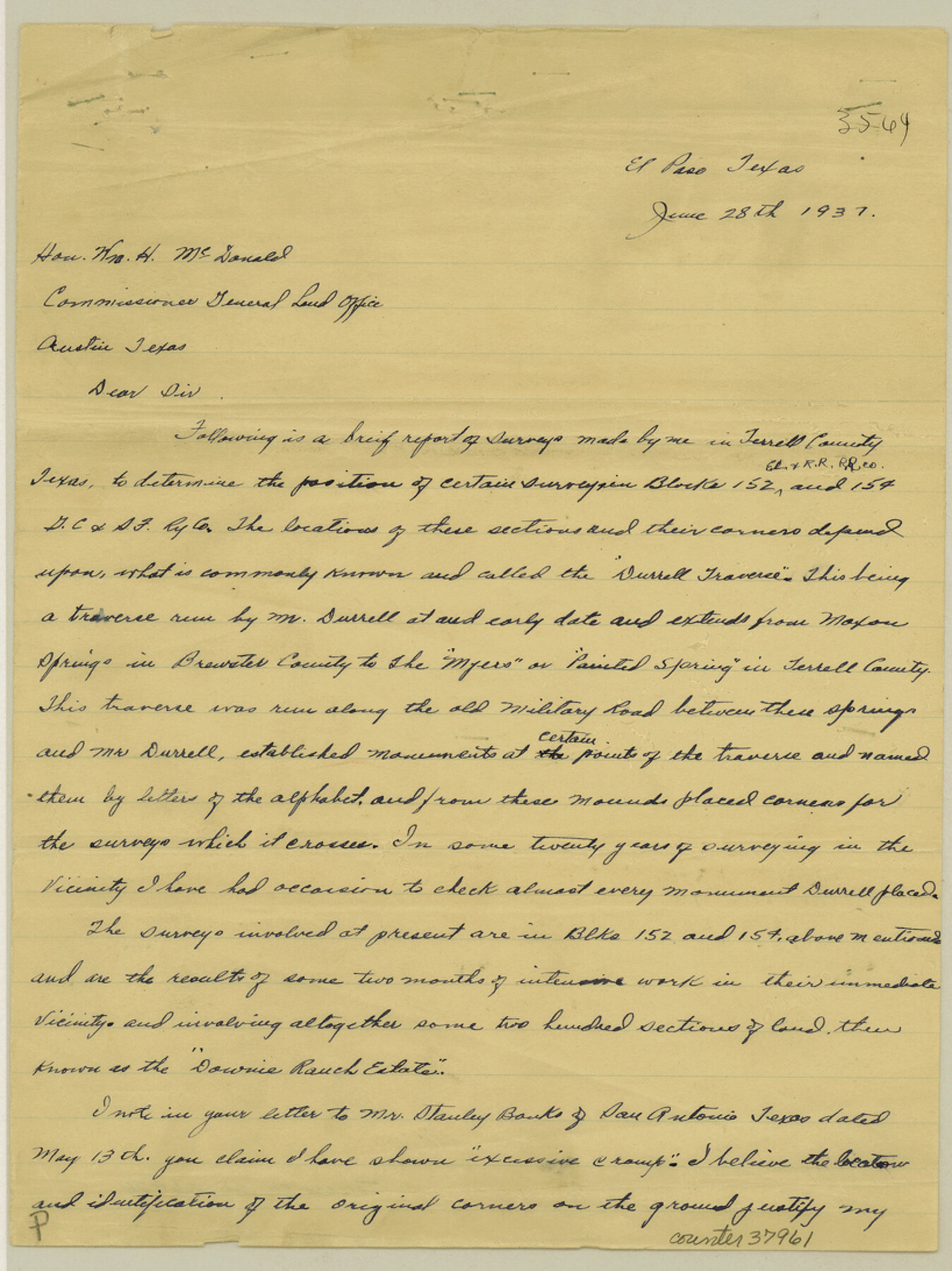
Terrell County Sketch File 26
[Report and sketch related to sections 8 and 16, Block 154 and section 18, Block 152]
-
Map/Doc
37961
-
Collection
General Map Collection
-
Object Dates
6/28/1937 (Creation Date)
7/23/1937 (File Date)
-
People and Organizations
James P. Dod (Surveyor/Engineer)
-
Counties
Terrell
-
Subjects
Surveying Sketch File
-
Height x Width
10.9 x 8.2 inches
27.7 x 20.8 cm
-
Medium
paper, manuscript
-
Scale
1" = 1000 varas
-
Features
Maxon Springs
Meyers Springs
Painted Springs
Old Military Road
Downie Ranch Estates
Part of: General Map Collection
Reagan County Rolled Sketch 18

Print $20.00
- Digital $50.00
Reagan County Rolled Sketch 18
Size 32.1 x 22.9 inches
Map/Doc 7444
Shelby County Working Sketch 7

Print $20.00
- Digital $50.00
Shelby County Working Sketch 7
1942
Size 40.2 x 44.2 inches
Map/Doc 63860
Jack County Sketch File 9b

Print $4.00
- Digital $50.00
Jack County Sketch File 9b
1856
Size 8.2 x 13.5 inches
Map/Doc 27525
Gonzales County

Print $20.00
- Digital $50.00
Gonzales County
1880
Size 26.5 x 23.4 inches
Map/Doc 4549
Intracoastal Waterway in Texas - Corpus Christi to Point Isabel including Arroyo Colorado to Mo. Pac. R.R. Bridge Near Harlingen

Print $20.00
- Digital $50.00
Intracoastal Waterway in Texas - Corpus Christi to Point Isabel including Arroyo Colorado to Mo. Pac. R.R. Bridge Near Harlingen
1933
Size 27.9 x 40.8 inches
Map/Doc 61878
Crockett County Rolled Sketch RC

Print $50.00
- Digital $50.00
Crockett County Rolled Sketch RC
1935
Size 43.2 x 31.1 inches
Map/Doc 8702
United States - Gulf Coast Texas - Southern part of Laguna Madre

Print $20.00
- Digital $50.00
United States - Gulf Coast Texas - Southern part of Laguna Madre
1933
Size 26.9 x 18.3 inches
Map/Doc 72952
Hale County Working Sketch 8

Print $20.00
- Digital $50.00
Hale County Working Sketch 8
1982
Size 22.2 x 34.5 inches
Map/Doc 63328
Freestone County Sketch File 27

Print $2.00
- Digital $50.00
Freestone County Sketch File 27
1934
Size 11.3 x 8.6 inches
Map/Doc 23098
Roberts County Working Sketch 29

Print $20.00
- Digital $50.00
Roberts County Working Sketch 29
1983
Size 18.6 x 34.8 inches
Map/Doc 63555
Garza County Working Sketch 9

Print $20.00
- Digital $50.00
Garza County Working Sketch 9
1952
Size 15.7 x 18.0 inches
Map/Doc 63156
[F. W. & D. C. Ry. Co. Alignment and Right of Way Map, Clay County]
![64723, [F. W. & D. C. Ry. Co. Alignment and Right of Way Map, Clay County], General Map Collection](https://historictexasmaps.com/wmedia_w700/maps/64723-1.tif.jpg)
Print $20.00
- Digital $50.00
[F. W. & D. C. Ry. Co. Alignment and Right of Way Map, Clay County]
1927
Size 18.6 x 11.8 inches
Map/Doc 64723
You may also like
St. L. S.-W. Ry. of Texas, Map of Lufkin Branch in Smith County, Texas

Print $40.00
- Digital $50.00
St. L. S.-W. Ry. of Texas, Map of Lufkin Branch in Smith County, Texas
1912
Size 24.3 x 122.9 inches
Map/Doc 64692
El Paso County Working Sketch 8

Print $20.00
- Digital $50.00
El Paso County Working Sketch 8
1952
Size 23.9 x 22.5 inches
Map/Doc 69030
Flight Mission No. BRE-1P, Frame 78, Nueces County

Print $20.00
- Digital $50.00
Flight Mission No. BRE-1P, Frame 78, Nueces County
1956
Size 18.6 x 22.4 inches
Map/Doc 86660
Galveston Bay and Approaches

Print $20.00
- Digital $50.00
Galveston Bay and Approaches
1933
Size 46.0 x 34.9 inches
Map/Doc 69874
Hewlett-Packard 32E scientific calculator

Hewlett-Packard 32E scientific calculator
1978
Map/Doc 97318
Mason County Rolled Sketch 2

Print $20.00
- Digital $50.00
Mason County Rolled Sketch 2
1952
Size 32.9 x 26.7 inches
Map/Doc 6675
Southern Part of Laguna Madre

Print $20.00
- Digital $50.00
Southern Part of Laguna Madre
1946
Size 43.8 x 34.5 inches
Map/Doc 73534
Flight Mission No. DCL-7C, Frame 42, Kenedy County

Print $20.00
- Digital $50.00
Flight Mission No. DCL-7C, Frame 42, Kenedy County
1943
Size 15.3 x 15.2 inches
Map/Doc 86030
Suburban Homes Addition

Print $2.00
- Digital $50.00
Suburban Homes Addition
1926
Size 12.9 x 9.2 inches
Map/Doc 92263
Houston County Sketch File 24a

Print $20.00
- Digital $50.00
Houston County Sketch File 24a
1873
Size 26.3 x 21.0 inches
Map/Doc 11787
Galveston County Sketch File 9

Print $6.00
- Digital $50.00
Galveston County Sketch File 9
1866
Size 10.1 x 8.1 inches
Map/Doc 23369
Flight Mission No. DQN-7K, Frame 34, Calhoun County

Print $20.00
- Digital $50.00
Flight Mission No. DQN-7K, Frame 34, Calhoun County
1953
Size 18.5 x 22.1 inches
Map/Doc 84472