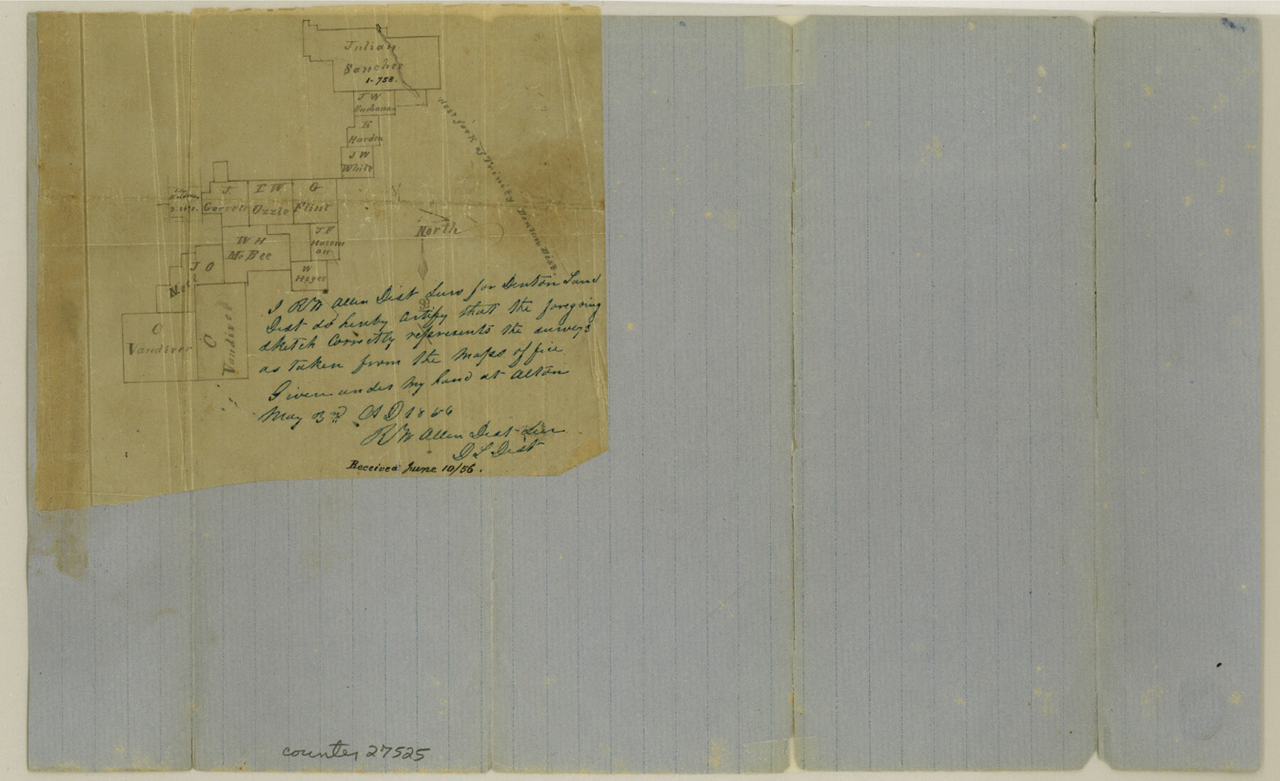
Jack County Sketch File 9b
[Sketch of surveys northwest of Jacksboro]
-
Map/Doc
27525
-
Collection
General Map Collection
-
Object Dates
1856/5/3 (Creation Date)
1856/6/10 (File Date)
-
People and Organizations
R.W. Allen (Surveyor/Engineer)
-
Counties
Jack
-
Subjects
Surveying Sketch File
-
Height x Width
8.2 x 13.5 inches
20.8 x 34.3 cm
-
Medium
paper, manuscript
-
Features
West Fork of Trinity River
Part of: General Map Collection
Zavala County Working Sketch 7

Print $20.00
- Digital $50.00
Zavala County Working Sketch 7
1948
Size 19.3 x 17.3 inches
Map/Doc 62082
Newton County Working Sketch 4

Print $20.00
- Digital $50.00
Newton County Working Sketch 4
1924
Size 24.1 x 21.0 inches
Map/Doc 71250
Matagorda County Sketch File 11

Print $6.00
- Digital $50.00
Matagorda County Sketch File 11
1885
Size 9.7 x 6.2 inches
Map/Doc 30768
[Surveys in Williamson County]
![78374, [Surveys in Williamson County], General Map Collection](https://historictexasmaps.com/wmedia_w700/maps/78374.tif.jpg)
Print $2.00
- Digital $50.00
[Surveys in Williamson County]
1846
Size 9.2 x 11.8 inches
Map/Doc 78374

Zapata County Rolled Sketch 20

Print $40.00
- Digital $50.00
Zapata County Rolled Sketch 20
1956
Size 21.2 x 49.1 inches
Map/Doc 10171
Dimmit County Sketch File 60

Print $4.00
- Digital $50.00
Dimmit County Sketch File 60
1991
Size 14.2 x 8.8 inches
Map/Doc 21206
Grayson County Working Sketch 20

Print $20.00
- Digital $50.00
Grayson County Working Sketch 20
1956
Size 25.4 x 31.3 inches
Map/Doc 63259
Parker County Working Sketch 13

Print $20.00
- Digital $50.00
Parker County Working Sketch 13
1978
Map/Doc 71463
Chambers County Sketch File 2

Print $8.00
- Digital $50.00
Chambers County Sketch File 2
Size 13.4 x 10.5 inches
Map/Doc 17518
Pecos County Rolled Sketch 42

Print $20.00
- Digital $50.00
Pecos County Rolled Sketch 42
1909
Size 19.6 x 41.0 inches
Map/Doc 7220
Kendall County Sketch File 20

Print $42.00
- Digital $50.00
Kendall County Sketch File 20
1916
Size 9.7 x 6.3 inches
Map/Doc 28713
You may also like
Nueces County NRC Article 33.136 Sketch 16

Print $68.00
- Digital $50.00
Nueces County NRC Article 33.136 Sketch 16
2012
Size 22.0 x 17.0 inches
Map/Doc 94804
Map of Fannin County

Print $20.00
- Digital $50.00
Map of Fannin County
1845
Size 34.7 x 36.5 inches
Map/Doc 16827

Nueces County Rolled Sketch 75

Print $40.00
- Digital $50.00
Nueces County Rolled Sketch 75
1945
Size 56.0 x 24.0 inches
Map/Doc 9618
Presidio County Rolled Sketch 30

Print $40.00
- Digital $50.00
Presidio County Rolled Sketch 30
Size 40.8 x 84.9 inches
Map/Doc 9767
Gaines County Working Sketch Graphic Index

Print $40.00
- Digital $50.00
Gaines County Working Sketch Graphic Index
1956
Size 42.7 x 54.0 inches
Map/Doc 76550
[Sketch focused on Southeast corner of Lubbock County]
![89899, [Sketch focused on Southeast corner of Lubbock County], Twichell Survey Records](https://historictexasmaps.com/wmedia_w700/maps/89899-1.tif.jpg)
Print $20.00
- Digital $50.00
[Sketch focused on Southeast corner of Lubbock County]
Size 42.8 x 36.9 inches
Map/Doc 89899
Nueces County Rolled Sketch 96

Print $44.00
Nueces County Rolled Sketch 96
1983
Size 24.2 x 36.5 inches
Map/Doc 7053
Cameron County Sketch File 5

Print $4.00
- Digital $50.00
Cameron County Sketch File 5
1978
Size 11.1 x 8.7 inches
Map/Doc 17030
Burleson County

Print $20.00
- Digital $50.00
Burleson County
1920
Size 40.7 x 45.2 inches
Map/Doc 66740
Current Miscellaneous File 16

Print $20.00
- Digital $50.00
Current Miscellaneous File 16
1951
Size 10.7 x 8.2 inches
Map/Doc 73830
