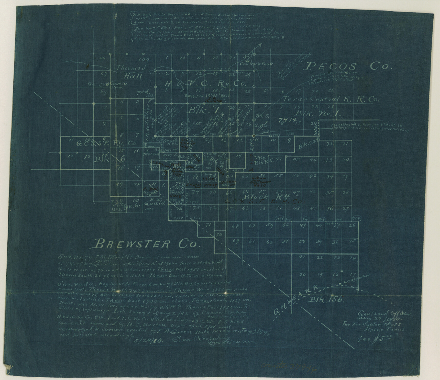
Terrell County Sketch File 20
[Office sketch of surveys north and northwest from Longfellow in Pecos and Brewster County]
-
Map/Doc
37946
-
Collection
General Map Collection
-
Object Dates
5/20/1910 (Creation Date)
-
People and Organizations
E. von Rosenberg (Draftsman)
-
Counties
Pecos Brewster
-
Subjects
Surveying Sketch File
-
Height x Width
10.9 x 12.6 inches
27.7 x 32.0 cm
-
Medium
blueprint/diazo
-
Features
Cap Rock Peak
GH&SA
Longfellow
Part of: General Map Collection
Roberts County Sketch File 5

Print $4.00
- Digital $50.00
Roberts County Sketch File 5
Size 8.0 x 9.8 inches
Map/Doc 35312
Copy of Surveyor's Field Book, Morris Browning - In Blocks 7, 5 & 4, I&GNRRCo., Hutchinson and Carson Counties, Texas

Print $2.00
- Digital $50.00
Copy of Surveyor's Field Book, Morris Browning - In Blocks 7, 5 & 4, I&GNRRCo., Hutchinson and Carson Counties, Texas
1888
Size 6.9 x 8.8 inches
Map/Doc 62282
Armstrong County Sketch File 8

Print $8.00
- Digital $50.00
Armstrong County Sketch File 8
Size 14.2 x 8.8 inches
Map/Doc 13705
La Salle County Rolled Sketch 25

Print $20.00
- Digital $50.00
La Salle County Rolled Sketch 25
Size 20.3 x 24.4 inches
Map/Doc 6586
Part of the boundary between the United States and Texas: north of Sabine River from the 36th to the 72nd mile mound (B.2)

Print $2.00
- Digital $50.00
Part of the boundary between the United States and Texas: north of Sabine River from the 36th to the 72nd mile mound (B.2)
1842
Size 12.7 x 8.9 inches
Map/Doc 65386
Houston County Sketch File 6a

Print $4.00
- Digital $50.00
Houston County Sketch File 6a
Size 10.2 x 8.1 inches
Map/Doc 26762
Sherman County Boundary File 3

Print $55.00
- Digital $50.00
Sherman County Boundary File 3
Size 9.2 x 8.6 inches
Map/Doc 58773
Flight Mission No. DQN-1K, Frame 42, Calhoun County

Print $20.00
- Digital $50.00
Flight Mission No. DQN-1K, Frame 42, Calhoun County
1953
Size 18.5 x 18.7 inches
Map/Doc 84142


Flight Mission No. CRC-4R, Frame 72, Chambers County

Print $20.00
- Digital $50.00
Flight Mission No. CRC-4R, Frame 72, Chambers County
1956
Size 18.8 x 22.4 inches
Map/Doc 84876
Kerr County Rolled Sketch 13

Print $20.00
- Digital $50.00
Kerr County Rolled Sketch 13
1951
Size 23.5 x 30.5 inches
Map/Doc 6498
You may also like
Hutchinson County Rolled Sketch 35

Print $20.00
- Digital $50.00
Hutchinson County Rolled Sketch 35
1934
Size 43.3 x 37.7 inches
Map/Doc 9245
Foard County Sketch File 19

Print $20.00
- Digital $50.00
Foard County Sketch File 19
1899
Size 17.7 x 16.5 inches
Map/Doc 11493
Comal County Sketch File 18

Print $4.00
- Digital $50.00
Comal County Sketch File 18
Size 6.7 x 13.0 inches
Map/Doc 19037
Terrell County Rolled Sketch 12

Print $20.00
- Digital $50.00
Terrell County Rolled Sketch 12
Size 37.1 x 31.5 inches
Map/Doc 7926
Galveston County Sketch File 5a

Print $4.00
- Digital $50.00
Galveston County Sketch File 5a
1847
Size 12.6 x 8.2 inches
Map/Doc 23360
Stonewall County Rolled Sketch 32
Print $20.00
- Digital $50.00
Stonewall County Rolled Sketch 32
1951
Size 19.4 x 33.6 inches
Map/Doc 7876
Lamar County Sketch File 5

Print $4.00
- Digital $50.00
Lamar County Sketch File 5
1877
Size 4.8 x 8.1 inches
Map/Doc 29284
Webb County Working Sketch 37

Print $20.00
- Digital $50.00
Webb County Working Sketch 37
1940
Size 25.0 x 20.4 inches
Map/Doc 72402
Bailey County Working Sketch 5

Print $20.00
- Digital $50.00
Bailey County Working Sketch 5
1945
Size 24.3 x 18.1 inches
Map/Doc 67592
Crockett County Rolled Sketch 80

Print $40.00
- Digital $50.00
Crockett County Rolled Sketch 80
1954
Size 24.8 x 55.5 inches
Map/Doc 8725
A Geological Map of the United States

Print $20.00
A Geological Map of the United States
Size 10.2 x 15.9 inches
Map/Doc 95281
General Highway Map. Detail of Cities and Towns in Dallas County, Texas [Dallas and vicinity]
![79068, General Highway Map. Detail of Cities and Towns in Dallas County, Texas [Dallas and vicinity], Texas State Library and Archives](https://historictexasmaps.com/wmedia_w700/maps/79068.tif.jpg)
Print $20.00
General Highway Map. Detail of Cities and Towns in Dallas County, Texas [Dallas and vicinity]
1936
Size 18.5 x 25.2 inches
Map/Doc 79068