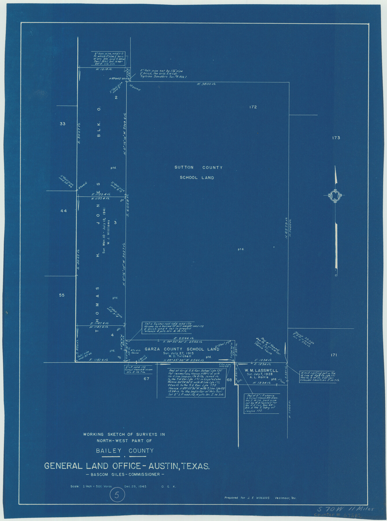
Bailey County Working Sketch 5
-
Map/Doc
67592
-
Collection
General Map Collection
-
Object Dates
12/29/1945 (Creation Date)
-
People and Organizations
Bascom Giles (GLO Commissioner)
Otto G. Kurio (Draftsman)
-
Counties
Bailey
-
Subjects
Surveying Working Sketch
-
Height x Width
24.3 x 18.1 inches
61.7 x 46.0 cm
-
Scale
1" = 500 varas
-
Comments
Surveys located about 11 miles South 70 degrees West of Muleshoe, Texas.
Part of: General Map Collection
Map of Armstrong County

Print $20.00
- Digital $50.00
Map of Armstrong County
1881
Size 25.8 x 19.9 inches
Map/Doc 3243
Val Verde County Working Sketch 36

Print $20.00
- Digital $50.00
Val Verde County Working Sketch 36
1942
Size 34.5 x 44.9 inches
Map/Doc 72171
Travis County State Real Property Sketch 16

Print $20.00
- Digital $50.00
Travis County State Real Property Sketch 16
2009
Size 48.1 x 36.1 inches
Map/Doc 90086
Burleson County Working Sketch 41

Print $20.00
- Digital $50.00
Burleson County Working Sketch 41
1990
Size 25.6 x 14.8 inches
Map/Doc 67760
Falls County Sketch File 20

Print $12.00
- Digital $50.00
Falls County Sketch File 20
1869
Size 10.0 x 8.3 inches
Map/Doc 22388
[Sketch of Surveys on Big Sandy Creek]
![179, [Sketch of Surveys on Big Sandy Creek], General Map Collection](https://historictexasmaps.com/wmedia_w700/maps/179.tif.jpg)
Print $2.00
- Digital $50.00
[Sketch of Surveys on Big Sandy Creek]
1841
Size 8.2 x 9.2 inches
Map/Doc 179
Calhoun County Sketch File 7

Print $12.00
- Digital $50.00
Calhoun County Sketch File 7
1947
Size 14.5 x 8.9 inches
Map/Doc 35925
King County Rolled Sketch 11

Print $20.00
- Digital $50.00
King County Rolled Sketch 11
1955
Size 40.2 x 46.6 inches
Map/Doc 9351
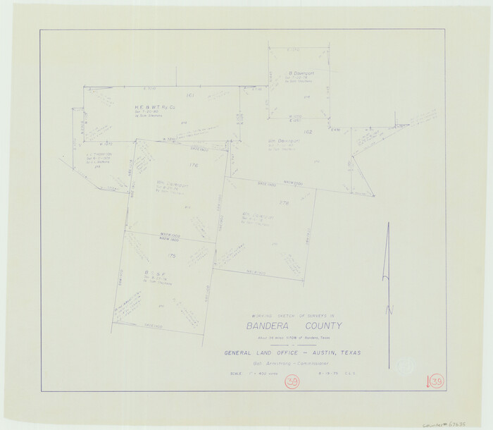
Bandera County Working Sketch 39
Print $20.00
- Digital $50.00
Bandera County Working Sketch 39
1975
Size 22.1 x 25.3 inches
Map/Doc 67635
Portion of States Submerged Area in Matagorda Bay

Print $20.00
- Digital $50.00
Portion of States Submerged Area in Matagorda Bay
1921
Size 15.7 x 15.1 inches
Map/Doc 2950
Motley County Boundary File 2a

Print $20.00
- Digital $50.00
Motley County Boundary File 2a
Size 14.3 x 8.6 inches
Map/Doc 57511
Hutchinson County Rolled Sketch 18

Print $20.00
- Digital $50.00
Hutchinson County Rolled Sketch 18
Size 30.4 x 32.6 inches
Map/Doc 9244
You may also like
Brazoria County Working Sketch 21

Print $20.00
- Digital $50.00
Brazoria County Working Sketch 21
1954
Size 41.5 x 41.8 inches
Map/Doc 67506
![88913, Map of Brown Co[unty], Library of Congress](https://historictexasmaps.com/wmedia_w700/maps/88913.tif.jpg)
San Patricio County Rolled Sketch 44

Print $55.00
- Digital $50.00
San Patricio County Rolled Sketch 44
1934
Size 9.8 x 14.9 inches
Map/Doc 48933
Lamar County Working Sketch 4

Print $20.00
- Digital $50.00
Lamar County Working Sketch 4
1920
Size 14.4 x 25.1 inches
Map/Doc 70265
Brazoria County NRC Article 33.136 Sketch 11

Print $24.00
- Digital $50.00
Brazoria County NRC Article 33.136 Sketch 11
2012
Size 24.0 x 18.0 inches
Map/Doc 94777
Brown County Sketch File 32

Print $84.00
- Digital $50.00
Brown County Sketch File 32
2018
Size 11.0 x 8.5 inches
Map/Doc 95206
Freestone County Sketch File 18

Print $4.00
- Digital $50.00
Freestone County Sketch File 18
1854
Size 9.7 x 8.2 inches
Map/Doc 23076
[Block J and vicinity]
![91239, [Block J and vicinity], Twichell Survey Records](https://historictexasmaps.com/wmedia_w700/maps/91239-1.tif.jpg)
Print $20.00
- Digital $50.00
[Block J and vicinity]
Size 19.8 x 30.5 inches
Map/Doc 91239
La Salle County Sketch File 17 and 17 1/2

Print $94.00
- Digital $50.00
La Salle County Sketch File 17 and 17 1/2
Size 8.8 x 8.1 inches
Map/Doc 29489
Railroad Track Map, H&TCRRCo., Falls County, Texas

Print $4.00
- Digital $50.00
Railroad Track Map, H&TCRRCo., Falls County, Texas
1918
Size 11.8 x 18.6 inches
Map/Doc 62840
Map of McLennan County

Print $40.00
- Digital $50.00
Map of McLennan County
1896
Size 48.8 x 53.7 inches
Map/Doc 7952
Parmer County

Print $20.00
- Digital $50.00
Parmer County
1926
Size 43.9 x 35.4 inches
Map/Doc 73259