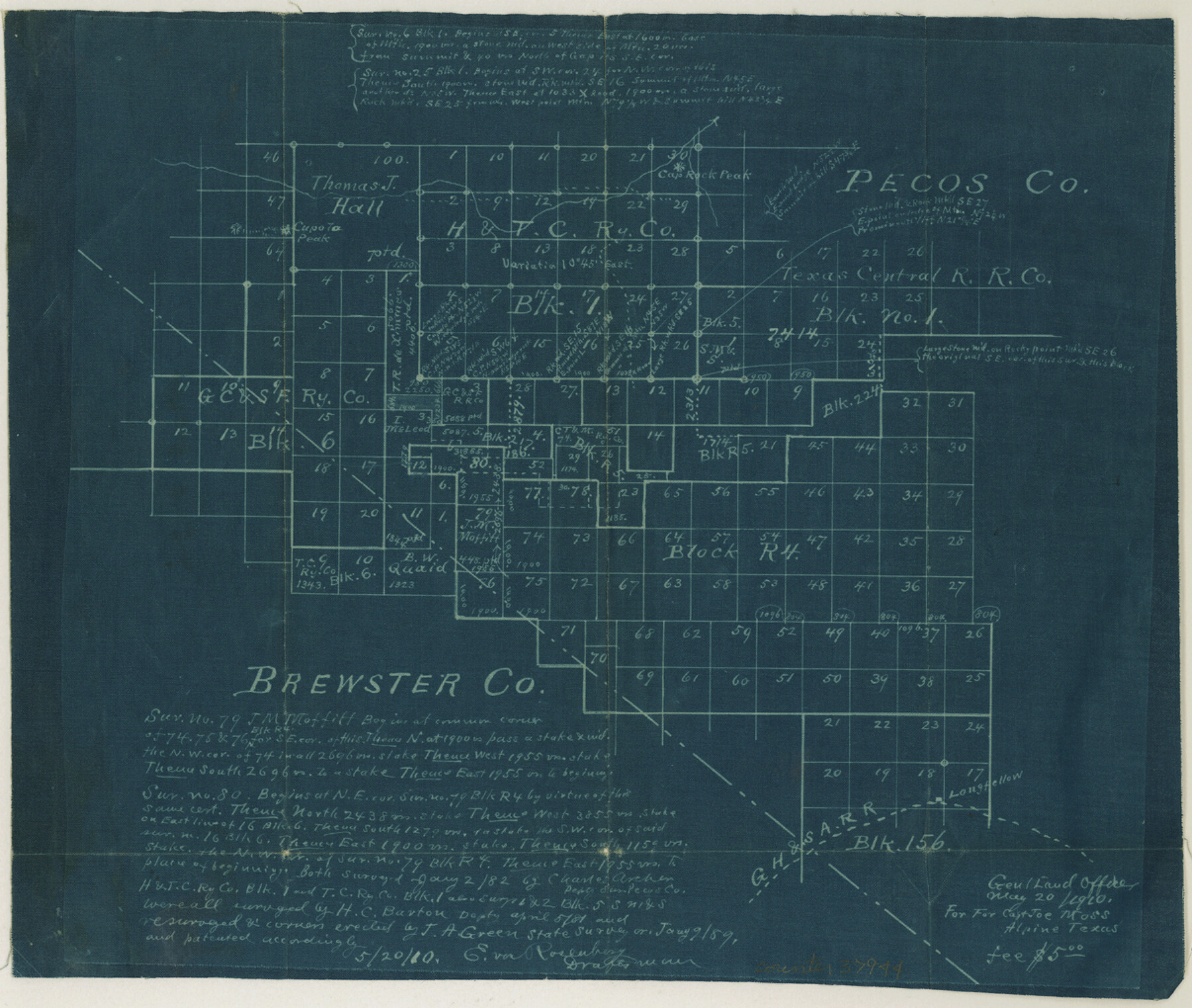
Terrell County Sketch File 19
[Office sketch of surveys north and northwest from Longfellow in Pecos and Brewster County]
-
Map/Doc
37944
-
Collection
General Map Collection
-
Object Dates
5/20/1910 (Creation Date)
-
People and Organizations
E. von Rosenberg (Draftsman)
-
Counties
Pecos Brewster
-
Subjects
Surveying Sketch File
-
Height x Width
10.2 x 12.1 inches
25.9 x 30.7 cm
-
Medium
blueprint/diazo
-
Features
Cupola Peak
Cap Rock Peak
Longfellow
GH&SA
Part of: General Map Collection
Colorado River, Bonus Sheet

Print $6.00
- Digital $50.00
Colorado River, Bonus Sheet
1941
Size 24.2 x 30.4 inches
Map/Doc 65307
[Sketch for Mineral Application 1487 -Big Wichita River, Ernest R. Smith]
![65684, [Sketch for Mineral Application 1487 -Big Wichita River, Ernest R. Smith], General Map Collection](https://historictexasmaps.com/wmedia_w700/maps/65684.tif.jpg)
Print $40.00
- Digital $50.00
[Sketch for Mineral Application 1487 -Big Wichita River, Ernest R. Smith]
1918
Size 32.2 x 130.1 inches
Map/Doc 65684
Flight Mission No. DQO-8K, Frame 57, Galveston County

Print $20.00
- Digital $50.00
Flight Mission No. DQO-8K, Frame 57, Galveston County
1952
Size 18.9 x 22.6 inches
Map/Doc 85164
Flight Mission No. BQR-13K, Frame 162, Brazoria County

Print $20.00
- Digital $50.00
Flight Mission No. BQR-13K, Frame 162, Brazoria County
1952
Size 18.6 x 22.4 inches
Map/Doc 84087
Shackelford County Sketch File 17

Print $4.00
Shackelford County Sketch File 17
2009
Size 14.0 x 8.5 inches
Map/Doc 89230
Kleberg County Aerial Photograph Index Sheet 2

Print $20.00
- Digital $50.00
Kleberg County Aerial Photograph Index Sheet 2
1956
Size 19.4 x 23.4 inches
Map/Doc 83719
Flight Mission No. DQN-3K, Frame 69, Calhoun County

Print $20.00
- Digital $50.00
Flight Mission No. DQN-3K, Frame 69, Calhoun County
1953
Size 18.5 x 22.3 inches
Map/Doc 84360
Cochran County Boundary File 3a

Print $34.00
- Digital $50.00
Cochran County Boundary File 3a
Size 11.2 x 8.8 inches
Map/Doc 51538
Winkler County Sketch File 3

Print $20.00
- Digital $50.00
Winkler County Sketch File 3
Size 38.6 x 33.8 inches
Map/Doc 10436
Bastrop County Rolled Sketch 1

Print $20.00
- Digital $50.00
Bastrop County Rolled Sketch 1
Size 30.0 x 23.9 inches
Map/Doc 5121
Leon County Working Sketch 55

Print $20.00
- Digital $50.00
Leon County Working Sketch 55
1989
Size 18.7 x 18.3 inches
Map/Doc 70455
Coleman County Sketch File 50

Print $4.00
- Digital $50.00
Coleman County Sketch File 50
Size 12.6 x 8.2 inches
Map/Doc 18853
You may also like
Brazos River Conservation and Reclamation District Official Boundary Line Survey, Parmer County

Print $20.00
- Digital $50.00
Brazos River Conservation and Reclamation District Official Boundary Line Survey, Parmer County
Size 36.6 x 24.8 inches
Map/Doc 91638
Coke County Working Sketch 28

Print $20.00
- Digital $50.00
Coke County Working Sketch 28
1965
Size 32.7 x 42.2 inches
Map/Doc 68065
Smith County Sketch File 16

Print $116.00
- Digital $50.00
Smith County Sketch File 16
1966
Size 10.8 x 7.3 inches
Map/Doc 36781
Flight Mission No. CGI-4N, Frame 165, Cameron County

Print $20.00
- Digital $50.00
Flight Mission No. CGI-4N, Frame 165, Cameron County
1955
Size 18.4 x 22.3 inches
Map/Doc 84673
Flight Mission No. CGI-3N, Frame 72, Cameron County

Print $20.00
- Digital $50.00
Flight Mission No. CGI-3N, Frame 72, Cameron County
1954
Size 18.5 x 22.3 inches
Map/Doc 84566
[Surveys along the Frio River at the confluence of the Sabinal River]
![78372, [Surveys along the Frio River at the confluence of the Sabinal River], General Map Collection](https://historictexasmaps.com/wmedia_w700/maps/78372.tif.jpg)
Print $2.00
- Digital $50.00
[Surveys along the Frio River at the confluence of the Sabinal River]
1845
Size 6.2 x 8.9 inches
Map/Doc 78372
[Block 1PD and Vicinity]
![91536, [Block 1PD and Vicinity], Twichell Survey Records](https://historictexasmaps.com/wmedia_w700/maps/91536-1.tif.jpg)
Print $3.00
- Digital $50.00
[Block 1PD and Vicinity]
Size 11.4 x 9.7 inches
Map/Doc 91536
Flight Mission No. DAG-17K, Frame 70, Matagorda County

Print $20.00
- Digital $50.00
Flight Mission No. DAG-17K, Frame 70, Matagorda County
1952
Size 18.6 x 22.4 inches
Map/Doc 86329
Gillespie County Rolled Sketch 7

Print $20.00
- Digital $50.00
Gillespie County Rolled Sketch 7
2008
Size 18.9 x 18.8 inches
Map/Doc 88818
[Surveys along the Leona and Frio Rivers]
![16, [Surveys along the Leona and Frio Rivers], General Map Collection](https://historictexasmaps.com/wmedia_w700/maps/16.tif.jpg)
Print $20.00
- Digital $50.00
[Surveys along the Leona and Frio Rivers]
1841
Size 12.4 x 13.1 inches
Map/Doc 16
Hudspeth County Sketch File 40

Print $8.00
- Digital $50.00
Hudspeth County Sketch File 40
1944
Size 11.2 x 8.6 inches
Map/Doc 27012
Brewster County Rolled Sketch 82A

Print $40.00
- Digital $50.00
Brewster County Rolled Sketch 82A
1952
Size 74.3 x 34.0 inches
Map/Doc 8498