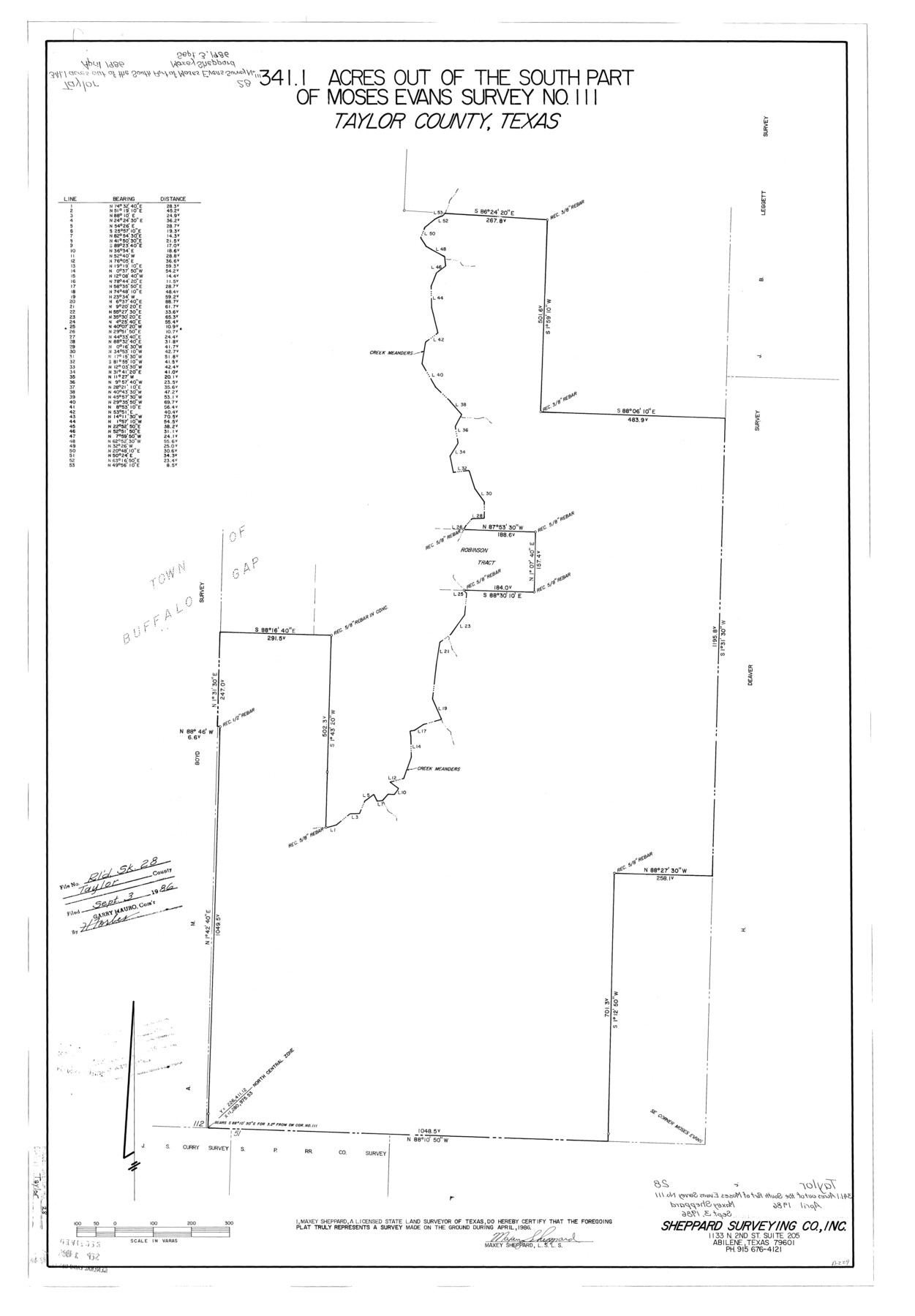
Taylor County Rolled Sketch 28
341.1 acres out of the south part of Moses Evans survey no. 111, Taylor County, Texas
-
Map/Doc
7921
-
Collection
General Map Collection
-
Object Dates
1986 (Survey Date)
1986/9/3 (File Date)
-
People and Organizations
Maxey Sheppard (Surveyor/Engineer)
-
Counties
Taylor
-
Subjects
Surveying Rolled Sketch
-
Height x Width
34.4 x 23.9 inches
87.4 x 60.7 cm
-
Medium
mylar, print
Part of: General Map Collection
Howard County Working Sketch 13

Print $20.00
- Digital $50.00
Howard County Working Sketch 13
1983
Size 33.3 x 37.3 inches
Map/Doc 66281
Foard County Working Sketch 7

Print $20.00
- Digital $50.00
Foard County Working Sketch 7
1953
Size 26.0 x 32.7 inches
Map/Doc 69198
Flight Mission No. BRA-16M, Frame 170, Jefferson County

Print $20.00
- Digital $50.00
Flight Mission No. BRA-16M, Frame 170, Jefferson County
1953
Size 18.6 x 22.4 inches
Map/Doc 85768
Jeff Davis County Sketch File 36

Print $40.00
- Digital $50.00
Jeff Davis County Sketch File 36
1951
Size 17.1 x 14.3 inches
Map/Doc 28048
Nueces County Rolled Sketch 93

Print $161.00
Nueces County Rolled Sketch 93
1983
Size 37.3 x 24.2 inches
Map/Doc 7029
Packery Channel

Print $20.00
- Digital $50.00
Packery Channel
1930
Size 26.6 x 37.1 inches
Map/Doc 2990
San Patricio County Sketch File 37

Print $94.00
- Digital $50.00
San Patricio County Sketch File 37
1915
Size 10.5 x 6.4 inches
Map/Doc 36142
[Anderson County]
![5051, [Anderson County], General Map Collection](https://historictexasmaps.com/wmedia_w700/maps/5051-GC.tif.jpg)
Print $20.00
- Digital $50.00
[Anderson County]
1848
Size 26.0 x 19.9 inches
Map/Doc 5051
Sketch of 103rd Meridian, W. L. Showing Conflict of Capitol Leagues

Print $40.00
- Digital $50.00
Sketch of 103rd Meridian, W. L. Showing Conflict of Capitol Leagues
Size 26.9 x 85.1 inches
Map/Doc 65505
Roberts County Working Sketch 3

Print $20.00
- Digital $50.00
Roberts County Working Sketch 3
1949
Size 18.0 x 14.3 inches
Map/Doc 63529
Jasper County Sketch File 11

Print $5.00
- Digital $50.00
Jasper County Sketch File 11
Size 11.1 x 9.6 inches
Map/Doc 27790
Gillespie County Boundary File 6

Print $2.00
- Digital $50.00
Gillespie County Boundary File 6
Size 11.3 x 8.9 inches
Map/Doc 53770
You may also like
Flight Mission No. DQN-2K, Frame 196, Calhoun County

Print $20.00
- Digital $50.00
Flight Mission No. DQN-2K, Frame 196, Calhoun County
1953
Size 16.3 x 16.1 inches
Map/Doc 84335
Dimmit County Boundary File 4

Print $14.00
- Digital $50.00
Dimmit County Boundary File 4
Size 14.1 x 8.8 inches
Map/Doc 52570
Tarrant County Working Sketch 20

Print $20.00
- Digital $50.00
Tarrant County Working Sketch 20
1999
Size 15.4 x 16.8 inches
Map/Doc 62437
Crockett County Rolled Sketch 29

Print $20.00
- Digital $50.00
Crockett County Rolled Sketch 29
1927
Size 22.0 x 36.9 inches
Map/Doc 5781
Geographical Observations on the Inner Margins of the Border and Coastal Reserves of Texas, 1824-1836

Geographical Observations on the Inner Margins of the Border and Coastal Reserves of Texas, 1824-1836
2022
Map/Doc 97131
Pecos County Rolled Sketch 44

Print $20.00
- Digital $50.00
Pecos County Rolled Sketch 44
1912
Size 22.9 x 37.6 inches
Map/Doc 7222
Mapa original de Texas por el Ciudadano Estevan F. Austin Presentado al Excmo. Sr. Presidente, por su Autor

Mapa original de Texas por el Ciudadano Estevan F. Austin Presentado al Excmo. Sr. Presidente, por su Autor
1830
Size 31.6 x 25.4 inches
Map/Doc 94562
Anderson County Rolled Sketch 14

Print $20.00
- Digital $50.00
Anderson County Rolled Sketch 14
1997
Size 30.1 x 36.5 inches
Map/Doc 77159
Andrews County Rolled Sketch 8

Print $40.00
- Digital $50.00
Andrews County Rolled Sketch 8
1928
Size 31.4 x 54.0 inches
Map/Doc 8388
Reconnaissance of the Coast of Texas between Matagorda and Corpus Christi Bays

Print $20.00
- Digital $50.00
Reconnaissance of the Coast of Texas between Matagorda and Corpus Christi Bays
1858
Size 25.2 x 21.4 inches
Map/Doc 75987
Crockett County Rolled Sketch JAS

Print $40.00
- Digital $50.00
Crockett County Rolled Sketch JAS
1938
Size 52.9 x 42.7 inches
Map/Doc 8699
Duval County Working Sketch 35

Print $20.00
- Digital $50.00
Duval County Working Sketch 35
1956
Size 17.2 x 16.5 inches
Map/Doc 68759