Taylor County Sketch File 21
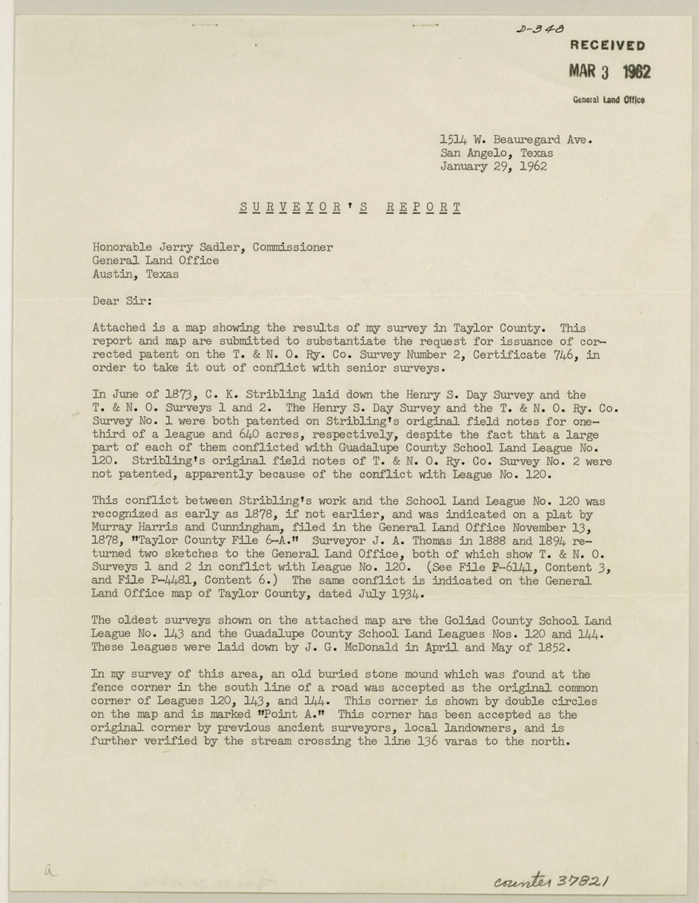
[Surveyor's report of resurvey of T. & N. O. R.R. survey 2 southwest from Abilene]
-
Map/Doc
37821
-
Collection
General Map Collection
-
Object Dates
1/29/1962 (Creation Date)
3/3/1962 (File Date)
-
People and Organizations
Wm. C. Wilson, Jr. (Surveyor/Engineer)
-
Counties
Taylor
-
Subjects
Surveying Sketch File
-
Height x Width
11.3 x 8.8 inches
28.7 x 22.4 cm
-
Medium
paper, print
-
Comments
See Taylor County Rolled Sketch 25 (7917) for sketch.
Related maps
Taylor County Rolled Sketch 25

Print $20.00
- Digital $50.00
Taylor County Rolled Sketch 25
1962
Size 27.1 x 46.0 inches
Map/Doc 7917
Part of: General Map Collection
San Augustine County Boundary File 1

Print $17.00
- Digital $50.00
San Augustine County Boundary File 1
Size 9.3 x 12.2 inches
Map/Doc 58540
Culberson County Working Sketch 42

Print $40.00
- Digital $50.00
Culberson County Working Sketch 42
1970
Size 49.1 x 44.0 inches
Map/Doc 68496
Jack County Sketch File 18c

Print $60.00
- Digital $50.00
Jack County Sketch File 18c
Size 20.0 x 30.7 inches
Map/Doc 11828
Ector County Working Sketch 20

Print $40.00
- Digital $50.00
Ector County Working Sketch 20
1958
Size 61.5 x 38.4 inches
Map/Doc 68863
Flight Mission No. DQO-1K, Frame 41, Galveston County

Print $20.00
- Digital $50.00
Flight Mission No. DQO-1K, Frame 41, Galveston County
1952
Size 18.8 x 22.5 inches
Map/Doc 84984
Kleberg County Rolled Sketch 10-24

Print $20.00
- Digital $50.00
Kleberg County Rolled Sketch 10-24
1952
Size 41.7 x 36.0 inches
Map/Doc 9386
Old Miscellaneous File 27

Print $28.00
- Digital $50.00
Old Miscellaneous File 27
1879
Size 14.4 x 8.8 inches
Map/Doc 75636
Flight Mission No. CRK-8P, Frame 104, Refugio County

Print $20.00
- Digital $50.00
Flight Mission No. CRK-8P, Frame 104, Refugio County
1956
Size 18.2 x 22.0 inches
Map/Doc 86965
Henderson County Sketch File 22

Print $14.00
- Digital $50.00
Henderson County Sketch File 22
1942
Size 14.2 x 8.9 inches
Map/Doc 26365
Trinity River, Reagor Springs Sheet/Waxahachie Creek

Print $4.00
- Digital $50.00
Trinity River, Reagor Springs Sheet/Waxahachie Creek
1931
Size 29.9 x 25.6 inches
Map/Doc 65236
Real County Working Sketch 41

Print $20.00
- Digital $50.00
Real County Working Sketch 41
1952
Size 34.1 x 23.6 inches
Map/Doc 71933
Coast Chart No. 210 - Aransas Pass and Corpus Christi Bay with the coast to latitude 27° 12', Texas

Print $20.00
- Digital $50.00
Coast Chart No. 210 - Aransas Pass and Corpus Christi Bay with the coast to latitude 27° 12', Texas
1907
Size 44.2 x 36.5 inches
Map/Doc 73449
You may also like
Culberson County Working Sketch 33

Print $20.00
- Digital $50.00
Culberson County Working Sketch 33
1960
Size 26.9 x 34.1 inches
Map/Doc 68486
Nolan County Sketch File 2

Print $40.00
- Digital $50.00
Nolan County Sketch File 2
Size 49.5 x 41.6 inches
Map/Doc 10556
Live Oak County Sketch File 21

Print $26.00
- Digital $50.00
Live Oak County Sketch File 21
1912
Size 16.8 x 8.0 inches
Map/Doc 30297
Navigation Maps of Gulf Intracoastal Waterway, Port Arthur to Brownsville, Texas

Print $4.00
- Digital $50.00
Navigation Maps of Gulf Intracoastal Waterway, Port Arthur to Brownsville, Texas
1951
Size 16.7 x 21.5 inches
Map/Doc 65421
Orange County NRC Article 33.136 Sketch 4

Print $24.00
- Digital $50.00
Orange County NRC Article 33.136 Sketch 4
2011
Size 22.6 x 31.2 inches
Map/Doc 93271

Galveston County Rolled Sketch HB

Print $40.00
- Digital $50.00
Galveston County Rolled Sketch HB
1936
Size 65.4 x 33.3 inches
Map/Doc 9085
Map of Hamilton County

Print $20.00
Map of Hamilton County
1876
Size 19.0 x 22.2 inches
Map/Doc 88945
Bexar County Working Sketch 10

Print $20.00
- Digital $50.00
Bexar County Working Sketch 10
1959
Size 22.6 x 34.5 inches
Map/Doc 67326
Upton County Rolled Sketch 59

Print $40.00
- Digital $50.00
Upton County Rolled Sketch 59
1994
Size 35.8 x 49.2 inches
Map/Doc 10637
General Highway Map, Walker County, Texas

Print $20.00
General Highway Map, Walker County, Texas
1940
Size 24.9 x 18.4 inches
Map/Doc 79269
General Highway Map, Pecos County, Texas

Print $20.00
General Highway Map, Pecos County, Texas
1961
Size 24.5 x 18.1 inches
Map/Doc 79627