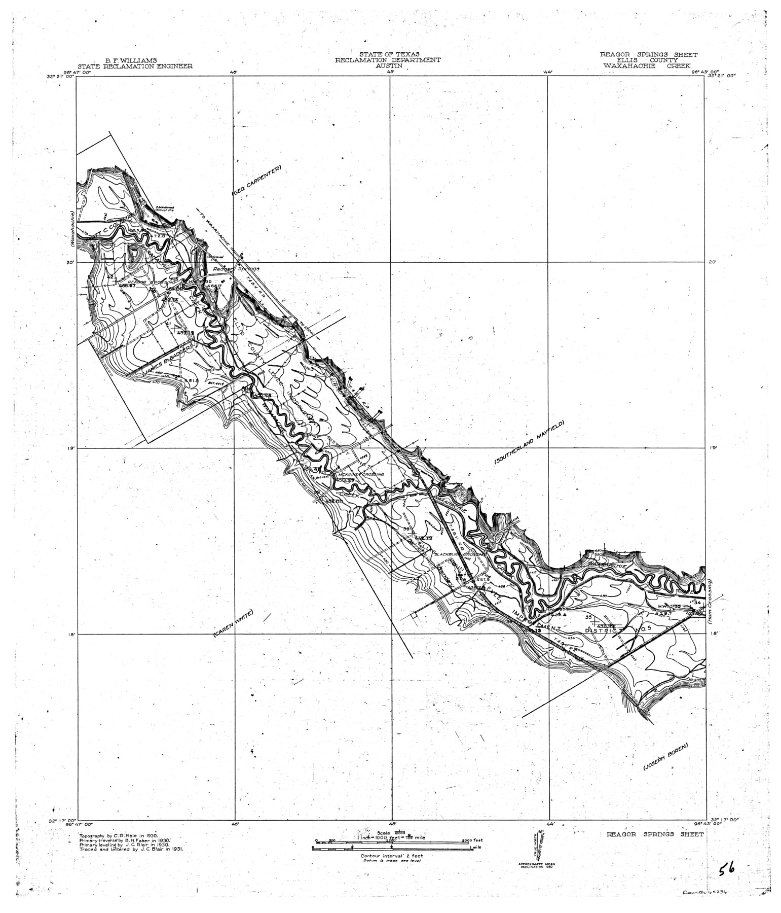
Trinity River, Reagor Springs Sheet/Waxahachie Creek
-
Map/Doc
65236
-
Collection
General Map Collection
-
Object Dates
1931 (Creation Date)
-
People and Organizations
Texas State Reclamation Department (Publisher)
Curtis R. Hale (Surveyor/Engineer)
J.C. Blair (Compiler)
J.C. Blair (Draftsman)
J.C. Blair (Surveyor/Engineer)
B.H. Faber (Surveyor/Engineer)
-
Counties
Ellis
-
Subjects
River Surveys Topographic
-
Height x Width
29.9 x 25.6 inches
75.9 x 65.0 cm
-
Comments
Reagor Springs Sheet located east of the Waxahachie Sheet and west of the Ham Crossing Sheet.
Part of: General Map Collection
Angelina County Working Sketch 33

Print $20.00
- Digital $50.00
Angelina County Working Sketch 33
1955
Size 22.7 x 24.2 inches
Map/Doc 67116
University Land in Hudspeth County showing Mineral Surveys in Blocks A, B, C, D, E, F, G, H, I, J, K, L, M, N

Print $40.00
- Digital $50.00
University Land in Hudspeth County showing Mineral Surveys in Blocks A, B, C, D, E, F, G, H, I, J, K, L, M, N
Size 39.7 x 48.4 inches
Map/Doc 2421
Clay County Sketch File 47

Print $6.00
- Digital $50.00
Clay County Sketch File 47
Size 11.3 x 17.4 inches
Map/Doc 18485
Flight Mission No. DCL-5C, Frame 76, Kenedy County

Print $20.00
- Digital $50.00
Flight Mission No. DCL-5C, Frame 76, Kenedy County
1943
Size 18.4 x 22.4 inches
Map/Doc 85859
Jefferson County Rolled Sketch 62
Print $40.00
- Digital $50.00
Jefferson County Rolled Sketch 62
1974
Size 78.4 x 43.1 inches
Map/Doc 9318
Hidalgo County Rolled Sketch 18

Print $20.00
- Digital $50.00
Hidalgo County Rolled Sketch 18
Size 34.0 x 18.3 inches
Map/Doc 6213
Culberson County Working Sketch 4

Print $20.00
- Digital $50.00
Culberson County Working Sketch 4
Size 37.7 x 32.2 inches
Map/Doc 68456
G. C. & S. F. Ry., San Saba Branch, Texas, Right of Way Map, Hall to Brady

Print $40.00
- Digital $50.00
G. C. & S. F. Ry., San Saba Branch, Texas, Right of Way Map, Hall to Brady
1916
Size 38.9 x 124.3 inches
Map/Doc 61418
Flight Mission No. CGI-3N, Frame 140, Cameron County

Print $20.00
- Digital $50.00
Flight Mission No. CGI-3N, Frame 140, Cameron County
1954
Size 18.8 x 22.5 inches
Map/Doc 84613
La Salle County Working Sketch 1

Print $20.00
- Digital $50.00
La Salle County Working Sketch 1
1929
Size 24.2 x 23.1 inches
Map/Doc 70302
Flight Mission No. DAG-21K, Frame 101, Matagorda County

Print $20.00
- Digital $50.00
Flight Mission No. DAG-21K, Frame 101, Matagorda County
1952
Size 18.6 x 22.4 inches
Map/Doc 86430
Chambers County Boundary File 3

Print $112.00
- Digital $50.00
Chambers County Boundary File 3
Size 52.5 x 3.9 inches
Map/Doc 51249
You may also like
Donley County Sketch File 4

Print $28.00
- Digital $50.00
Donley County Sketch File 4
1881
Size 12.8 x 8.3 inches
Map/Doc 21219

Portion of States Submerged Area in Matagorda Bay

Print $20.00
- Digital $50.00
Portion of States Submerged Area in Matagorda Bay
1922
Size 15.2 x 14.8 inches
Map/Doc 2953
Cherokee County Sketch File 34

Print $12.00
- Digital $50.00
Cherokee County Sketch File 34
1954
Size 11.2 x 8.9 inches
Map/Doc 18198
Flight Mission No. BRE-2P, Frame 109, Nueces County

Print $20.00
- Digital $50.00
Flight Mission No. BRE-2P, Frame 109, Nueces County
1956
Size 18.6 x 22.5 inches
Map/Doc 86794
Duval County Working Sketch 23

Print $20.00
- Digital $50.00
Duval County Working Sketch 23
1943
Size 41.8 x 37.8 inches
Map/Doc 68747
San Patricio County Rolled Sketch 48

Print $20.00
- Digital $50.00
San Patricio County Rolled Sketch 48
1984
Size 42.5 x 26.8 inches
Map/Doc 9903
Brown County Working Sketch 5

Print $20.00
- Digital $50.00
Brown County Working Sketch 5
1939
Size 20.9 x 24.0 inches
Map/Doc 67770
Bell County Sketch File 23

Print $4.00
- Digital $50.00
Bell County Sketch File 23
1873
Size 8.2 x 12.8 inches
Map/Doc 14414
[West Half of Hutchinson County South of the Canadian River]
![91179, [West Half of Hutchinson County South of the Canadian River], Twichell Survey Records](https://historictexasmaps.com/wmedia_w700/maps/91179-1.tif.jpg)
Print $20.00
- Digital $50.00
[West Half of Hutchinson County South of the Canadian River]
Size 18.4 x 17.0 inches
Map/Doc 91179
Layout of the porciones as described in the Visita General of Revilla (Guerrero), 1767, along with six tracts distributed by Gov. Lasaga in 1784 and three others (39-41) assigned at a later date

Layout of the porciones as described in the Visita General of Revilla (Guerrero), 1767, along with six tracts distributed by Gov. Lasaga in 1784 and three others (39-41) assigned at a later date
2009
Size 11.0 x 8.5 inches
Map/Doc 94044
Flight Mission No. CRC-4R, Frame 180, Chambers County

Print $20.00
- Digital $50.00
Flight Mission No. CRC-4R, Frame 180, Chambers County
1956
Size 18.6 x 22.2 inches
Map/Doc 84931