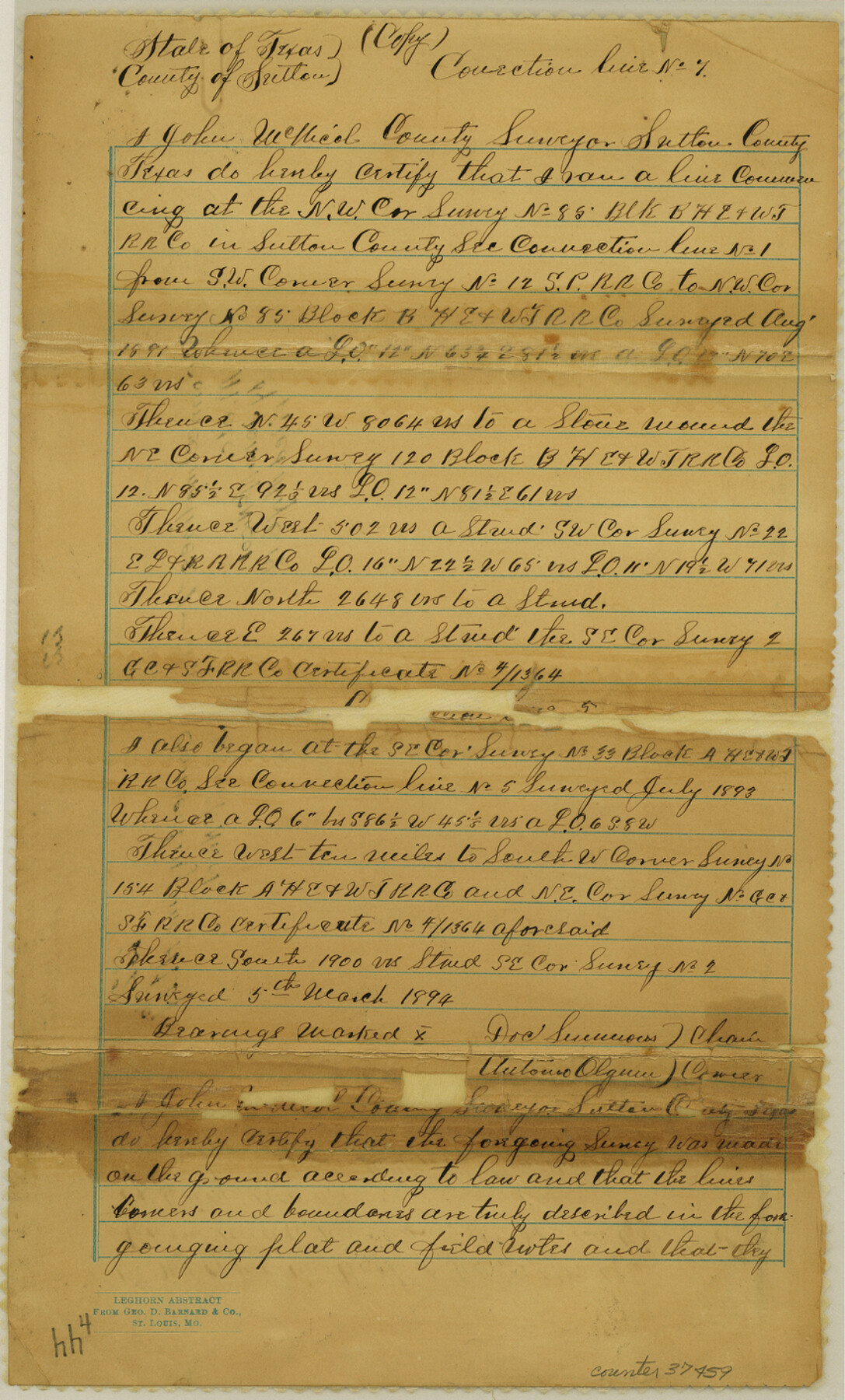
Sutton County Sketch File 22
[Connecting lines numbers 7, 5, A1, etc]
-
Map/Doc
37459
-
Collection
General Map Collection
-
Object Dates
1918/5/6 (File Date)
1891 (Survey Date)
1894/3/5 (Survey Date)
-
People and Organizations
John McNicol (Surveyor/Engineer)
Doc Simmons (Chainman/Field Personnel)
Antonio Oiguin (Chainman/Field Personnel)
-
Counties
Sutton
-
Subjects
Surveying Sketch File
-
Height x Width
14.2 x 8.5 inches
36.1 x 21.6 cm
-
Medium
paper, manuscript
Part of: General Map Collection
Montague County Working Sketch 4

Print $20.00
- Digital $50.00
Montague County Working Sketch 4
1920
Size 25.3 x 22.0 inches
Map/Doc 71070
Terrell County Rolled Sketch 28

Print $40.00
- Digital $50.00
Terrell County Rolled Sketch 28
1929
Size 28.0 x 67.7 inches
Map/Doc 7935
Sabine County Working Sketch 13

Print $20.00
- Digital $50.00
Sabine County Working Sketch 13
1935
Size 35.3 x 44.2 inches
Map/Doc 63684
Val Verde County Sketch File Z11

Print $40.00
- Digital $50.00
Val Verde County Sketch File Z11
1895
Size 17.6 x 12.7 inches
Map/Doc 39138
Cameron County Aerial Photograph Index Sheet 4

Print $20.00
- Digital $50.00
Cameron County Aerial Photograph Index Sheet 4
1955
Size 19.3 x 17.4 inches
Map/Doc 83676
[Sketch for Mineral Application 24072, San Jacinto River]
![65603, [Sketch for Mineral Application 24072, San Jacinto River], General Map Collection](https://historictexasmaps.com/wmedia_w700/maps/65603.tif.jpg)
Print $20.00
- Digital $50.00
[Sketch for Mineral Application 24072, San Jacinto River]
1929
Size 23.4 x 17.6 inches
Map/Doc 65603
USGS Topographic: Texas-Oklahoma Denison Quadrangle

Print $20.00
- Digital $50.00
USGS Topographic: Texas-Oklahoma Denison Quadrangle
1901
Size 21.3 x 17.4 inches
Map/Doc 75108
Pecos County Working Sketch 3

Print $20.00
- Digital $50.00
Pecos County Working Sketch 3
1927
Map/Doc 71473
Blanco County Working Sketch 20

Print $20.00
- Digital $50.00
Blanco County Working Sketch 20
1960
Size 27.3 x 36.4 inches
Map/Doc 67380
Flight Mission No. DAG-19K, Frame 56, Matagorda County

Print $20.00
- Digital $50.00
Flight Mission No. DAG-19K, Frame 56, Matagorda County
1952
Size 18.5 x 22.3 inches
Map/Doc 86383
Mason County Sketch File 23

Print $42.00
- Digital $50.00
Mason County Sketch File 23
1932
Size 11.2 x 8.8 inches
Map/Doc 30723
Yoakum County Working Sketch 1

Print $20.00
- Digital $50.00
Yoakum County Working Sketch 1
1949
Size 18.5 x 19.1 inches
Map/Doc 62023
You may also like
Outline of the Geology of the Globe

Print $20.00
Outline of the Geology of the Globe
1853
Size 19.3 x 23.6 inches
Map/Doc 95282
Calhoun County Rolled Sketch 14

Print $20.00
- Digital $50.00
Calhoun County Rolled Sketch 14
Size 22.3 x 40.8 inches
Map/Doc 5456
Pecos County Working Sketch 23

Print $20.00
- Digital $50.00
Pecos County Working Sketch 23
1927
Size 45.6 x 40.6 inches
Map/Doc 71494
Flight Mission No. DIX-5P, Frame 145, Aransas County

Print $20.00
- Digital $50.00
Flight Mission No. DIX-5P, Frame 145, Aransas County
1956
Size 17.8 x 18.1 inches
Map/Doc 83806
Lubbock County Boundary File 11

Print $68.00
- Digital $50.00
Lubbock County Boundary File 11
Size 14.7 x 9.2 inches
Map/Doc 56583
Culberson County Working Sketch 1

Print $20.00
- Digital $50.00
Culberson County Working Sketch 1
Size 21.6 x 42.7 inches
Map/Doc 68453
Flight Mission No. DQO-8K, Frame 76, Galveston County

Print $20.00
- Digital $50.00
Flight Mission No. DQO-8K, Frame 76, Galveston County
1952
Size 18.6 x 22.5 inches
Map/Doc 85180
[Right of Way Map, Belton Branch of the M.K.&T. RR.]
![64221, [Right of Way Map, Belton Branch of the M.K.&T. RR.], General Map Collection](https://historictexasmaps.com/wmedia_w700/maps/64221.tif.jpg)
Print $20.00
- Digital $50.00
[Right of Way Map, Belton Branch of the M.K.&T. RR.]
1896
Size 22.0 x 7.1 inches
Map/Doc 64221
Shackelford County Working Sketch 6

Print $20.00
- Digital $50.00
Shackelford County Working Sketch 6
1963
Size 26.1 x 28.9 inches
Map/Doc 63846
[Sketch for Mineral Application 24072, San Jacinto River]
![65585, [Sketch for Mineral Application 24072, San Jacinto River], General Map Collection](https://historictexasmaps.com/wmedia_w700/maps/65585.tif.jpg)
Print $20.00
- Digital $50.00
[Sketch for Mineral Application 24072, San Jacinto River]
1929
Size 21.7 x 11.1 inches
Map/Doc 65585
[Blk. B, Secs. 111-114 and vicinity]
![90340, [Blk. B, Secs. 111-114 and vicinity], Twichell Survey Records](https://historictexasmaps.com/wmedia_w700/maps/90340-1.tif.jpg)
Print $20.00
- Digital $50.00
[Blk. B, Secs. 111-114 and vicinity]
Size 31.3 x 38.7 inches
Map/Doc 90340
Midland County Sketch File 3

Print $20.00
- Digital $50.00
Midland County Sketch File 3
1886
Size 18.3 x 25.2 inches
Map/Doc 12081