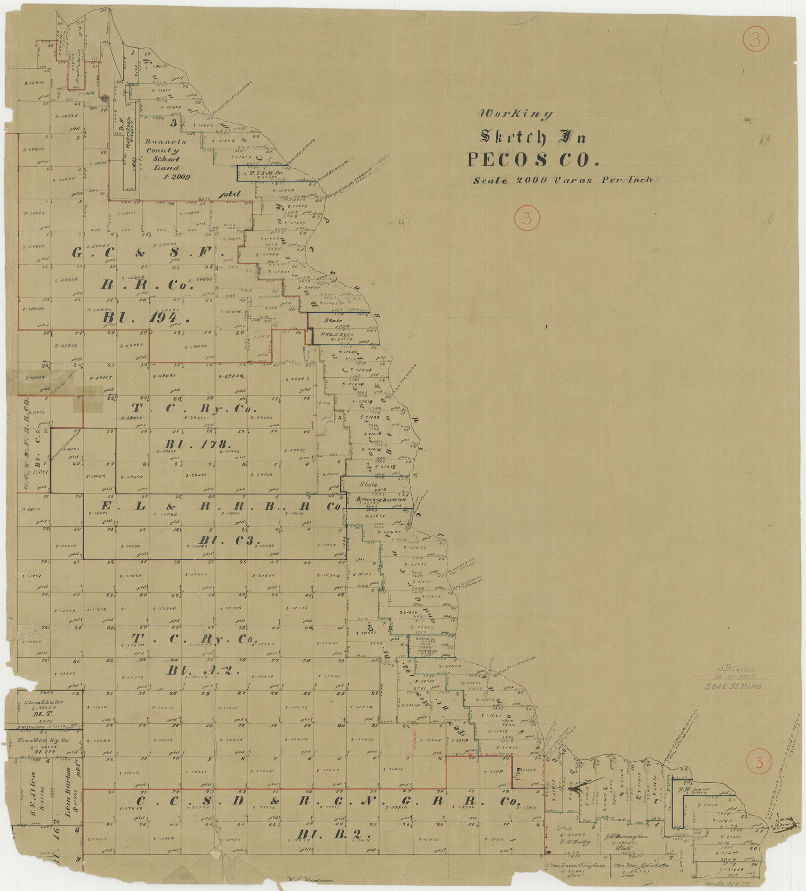
Pecos County Working Sketch 3
-
Map/Doc
71473
-
Collection
General Map Collection
-
Object Dates
10/18/1927 (Creation Date)
-
People and Organizations
J. Bascom Giles (Draftsman)
-
Counties
Pecos
-
Subjects
Surveying Working Sketch
-
Scale
1" = 2000 varas
Part of: General Map Collection
Trinity County Sketch File 27

Print $4.00
- Digital $50.00
Trinity County Sketch File 27
Size 12.0 x 8.6 inches
Map/Doc 38562
Flight Mission No. BQR-16K, Frame 32, Brazoria County

Print $20.00
- Digital $50.00
Flight Mission No. BQR-16K, Frame 32, Brazoria County
1952
Size 18.5 x 22.2 inches
Map/Doc 84099
Dawson County Working Sketch 9

Print $20.00
- Digital $50.00
Dawson County Working Sketch 9
1943
Size 15.2 x 13.0 inches
Map/Doc 68553
Dimmit County Working Sketch 50

Print $20.00
- Digital $50.00
Dimmit County Working Sketch 50
1981
Size 34.0 x 39.0 inches
Map/Doc 68711
La Salle County Working Sketch 11

Print $20.00
- Digital $50.00
La Salle County Working Sketch 11
1929
Size 29.3 x 20.7 inches
Map/Doc 70312
Travis County Working Sketch 42

Print $20.00
- Digital $50.00
Travis County Working Sketch 42
1974
Size 32.5 x 35.2 inches
Map/Doc 69426
Copano, St. Charles, Aransas and Red Fish Bays, in Aransas and Nueces Counties, showing Subdivision for Mineral Development

Print $40.00
- Digital $50.00
Copano, St. Charles, Aransas and Red Fish Bays, in Aransas and Nueces Counties, showing Subdivision for Mineral Development
1949
Size 55.9 x 40.0 inches
Map/Doc 1914
Crockett County Sketch File 79a

Print $6.00
- Digital $50.00
Crockett County Sketch File 79a
1937
Size 14.2 x 8.5 inches
Map/Doc 19890
Wilbarger County Working Sketch 2b

Print $20.00
- Digital $50.00
Wilbarger County Working Sketch 2b
1922
Size 19.8 x 20.0 inches
Map/Doc 72540
Runnels County Sketch File 17

Print $6.00
Runnels County Sketch File 17
Size 11.0 x 13.6 inches
Map/Doc 35474
Presidio County Sketch File 1

Print $40.00
- Digital $50.00
Presidio County Sketch File 1
1857
Size 24.7 x 16.0 inches
Map/Doc 11703
Midland County

Print $20.00
- Digital $50.00
Midland County
1896
Size 21.5 x 20.0 inches
Map/Doc 3877
You may also like
General Highway Map. Detail of Cities and Towns in Dallas County, Texas [Dallas and vicinity]
![79432, General Highway Map. Detail of Cities and Towns in Dallas County, Texas [Dallas and vicinity], Texas State Library and Archives](https://historictexasmaps.com/wmedia_w700/maps/79432.tif.jpg)
Print $20.00
General Highway Map. Detail of Cities and Towns in Dallas County, Texas [Dallas and vicinity]
1961
Size 18.1 x 24.7 inches
Map/Doc 79432

City of Austin, Texas and Suburban Territory

Print $40.00
- Digital $50.00
City of Austin, Texas and Suburban Territory
1952
Size 52.9 x 47.2 inches
Map/Doc 73582
Glasscock County Rolled Sketch 13

Print $20.00
- Digital $50.00
Glasscock County Rolled Sketch 13
Size 24.9 x 19.4 inches
Map/Doc 6019
Edwards County Boundary File 28

Print $50.00
- Digital $50.00
Edwards County Boundary File 28
Size 12.9 x 5.2 inches
Map/Doc 52932
Flight Mission No. CRC-3R, Frame 51, Chambers County

Print $20.00
- Digital $50.00
Flight Mission No. CRC-3R, Frame 51, Chambers County
1956
Size 18.7 x 22.4 inches
Map/Doc 84824

Edwards County Working Sketch 58

Print $20.00
- Digital $50.00
Edwards County Working Sketch 58
1953
Size 22.4 x 29.8 inches
Map/Doc 68934
Hardeman County

Print $20.00
- Digital $50.00
Hardeman County
1935
Size 42.8 x 40.0 inches
Map/Doc 77302
Flight Mission No. CGI-4N, Frame 184, Cameron County

Print $20.00
- Digital $50.00
Flight Mission No. CGI-4N, Frame 184, Cameron County
1955
Size 18.7 x 22.3 inches
Map/Doc 84687
Crosby County Working Sketch 13

Print $20.00
- Digital $50.00
Crosby County Working Sketch 13
1963
Size 17.9 x 30.7 inches
Map/Doc 68447
Webb County Rolled Sketch 12

Print $20.00
- Digital $50.00
Webb County Rolled Sketch 12
Size 17.6 x 18.5 inches
Map/Doc 8176